File:Battle Trebia-en.gif
Μετάβαση στην πλοήγηση
Πήδηση στην αναζήτηση
Μέγεθος αυτής της προεπισκόπησης: 793 × 599 εικονοστοιχεία . Άλλες αναλύσεις: 318 × 240 εικονοστοιχεία | 635 × 480 εικονοστοιχεία | 999 × 755 εικονοστοιχεία.
Πρωτότυπο αρχείο (999 × 755 εικονοστοιχεία, μέγεθος αρχείου: 344 KB, τύπος MIME: image/gif, κυκλικά επαναλαμβανόμενο, 10 καρέ, 20 s)
Λεζάντες
Λεζάντες
Δεν ορίστηκε λεζάντα
| Περιγραφή |
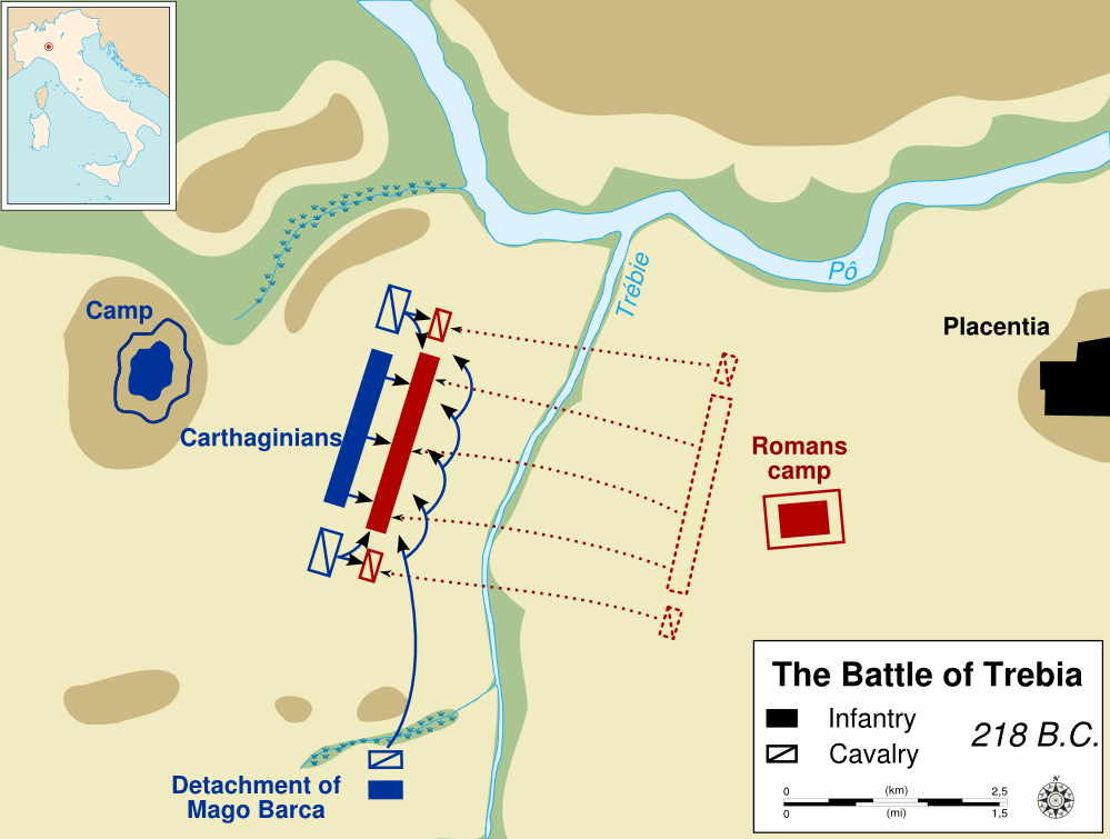
English: Demonstration of the way to create a vectorial map, layer after layer:
1.Valley ; 2.Plain ; 3.Hills ; 4.Rivers ; 5.Troops ; 6.Moves ; 7.Texts ; 8.Localisor ; 9.Legend.
Français : Démonstration de la construction de carte vectorielle calque après calque:
1.Vallée ; 2.Plaines ; 3.Colines ; 4.Rivières ; 5.Troupes ; 6.Déplacements ; 7.Labels ; 8.Localisateur ; 9.Légende.
From: English: The battle of Trebia, 218 B.C., second Punic War, between Carthaginians and Romans La bataille de la Trébie, -218, durant la seconde guerre punique, entre les Carthaginois et les Romains. Русский: Схема послойного создания векторной карты. 1. Долина ; 2. Равнина ; 3. Холмы ; 4. Реки ; 5. Войска ; 6. Передвижения ; 7. Надписи ; 8.Врезка с картой более крупного региона; 9.Легенда. Схема битвы при Треббии на английском языке. |
| Ημερομηνία | (UTC) |
| Πηγή | Frank Martini, cartographer. Department of History, United States Military Academy. |
| Δημιουργός |
| Αυτή είναι μία ρετουσαρισμένη εικόνα, που σημαίνει ότι έχει μεταβληθεί ψηφιακά από την αρχική της έκδοση. Τροποποιήσεις: animated. Η πρωτότυπη μπορεί να βρεθεί εδώ: Battle Trebia-en.svg. Οι τροποποιήσεις έγιναν από τον Yug.
|
This work is in the public domain in the United States because it is a work prepared by an officer or employee of the United States Government as part of that person’s official duties under the terms of Title 17, Chapter 1, Section 105 of the US Code.
Note: This only applies to original works of the Federal Government and not to the work of any individual U.S. state, territory, commonwealth, county, municipality, or any other subdivision. This template also does not apply to postage stamp designs published by the United States Postal Service since 1978. (See § 313.6(C)(1) of Compendium of U.S. Copyright Office Practices). It also does not apply to certain US coins; see The US Mint Terms of Use.
|
 | |
| Αυτό το αρχείο έχει χαρακτηριστεί ως απαλλαγμένο από γνωστούς περιορισμούς βάσει της νομοθεσίας περί πνευματικής ιδιοκτησίας, περιλαμβανομένων όλων των συναφών και συγγενικών δικαιωμάτων. | ||
Καταγραφές ανεβασμάτων πρωτότυπου αρχείου[επεξεργασία]
This image is a derivative work of the following images:
- Image:Battle_Trebia-en.svg licensed with PD-USGov
- 2008-07-14T14:51:23Z Yug 999x755 (96419 Bytes) update with better layer code
- 2007-10-17T11:22:31Z Sémhur 999x755 (97727 Bytes) {{Information |Description= {{en|1= The [[:en:Battle of the Trebia|battle of Trebia]], 218 B.C., second Punic War, between Carthaginians and Romans }}{{fr}} La [[:fr:Bataille de la Trébie|bataille de la Trébie]], -218, durant
Uploaded with derivativeFX
Ιστορικό αρχείου
Πατήστε σε μια ημερομηνία/ώρα για να δείτε το αρχείο όπως εμφανιζόταν εκείνη την χρονική στιγμή.
| Ημερομηνία/Ώρα | Μικρογραφία | Διαστάσεις | Χρήστης | Σχόλιο | |
|---|---|---|---|---|---|
| τρέχον | 00:58, 15 Ιουλίου 2008 | | 999 × 755 (344 KB) | Yug (συζήτηση | Συνεισφορά) | {{Information |Description= |Source= |Date= |Author= |Permission= |other_versions= }} |
| 20:06, 14 Ιουλίου 2008 |  | 999 × 755 (311 KB) | Yug (συζήτηση | Συνεισφορά) | {{Information |Description={{en}} The battle of Trebia, 218 B.C., second Punic War, between Carthaginians and Romans {{fr}} La bataille de la Trébie, -218, durant la seconde guerre punique, entr |
Δεν μπορείτε να αντικαταστήσετε αυτό το αρχείο.
Χρήση αρχείου
Η ακόλουθη σελίδα χρησιμοποιεί προς αυτό το αρχείο:
Καθολική χρήση αρχείου
Τα ακόλουθα άλλα wiki χρησιμοποιούν αυτό το αρχείο:
- Χρήση σε el.wikipedia.org
- Χρήση σε en.wikipedia.org
- Wikipedia:WikiProject Maps
- User:IYY
- User:Joe Roe
- User:Bduke
- User:Nick-D
- User:Erp
- User talk:Ogram
- User:Faizhaider
- User:Dcmacnut
- User:Buaidh
- Wikipedia:Graphics Lab/Resources/Tutorials
- User:Nimbusania
- User:Advanstra
- Template:User WikiProject Maps
- User:Justinmorris
- User:Justinmorris/Userbox
- User:Phizzy
- User talk:Kevinpaulscarrott
- User:Yug
- Wikipedia:Graphics Lab/Image workshop/Archive/Aug 2008
- User:Gapo
- User:Nebraska3
- User:Paris1127
- Wikipedia:WikiProject Maps/Conventions
- Wikipedia:WikiProject Maps/Conventions/Exchanges maps
- Wikipedia:WikiProject Maps/Conventions/Area maps
- Wikipedia:WikiProject Maps/Conventions/Topographic maps
- Wikipedia:WikiProject Maps/Conventions/Location maps
- Wikipedia:WikiProject Maps/Conventions/Locator maps
- Template:Map conventions
- User:Yug/Map convention
- Wikipedia:WikiProject Maps/Conventions/Historical maps
- User:Rustbelt Maps
- User:Nafsadh
- User:Wereldburger758
- User:DiverDave/Useful
- User:ChristineBush
- User:Amitchell125
- User:Alcides Pinto
- User:Nate Wessel
- Wikipedia:WikiProject Maps/Conventions/Orthographic maps
- User:Odysseus1479
- User:Ryderofpelham123
- User:Wolfgang8741
- User:Rossche
- User:Jm34harvey/Mapping
- Wikipedia talk:WikiProject Maps/Archive 2009
- Wikipedia talk:WikiProject Maps/Archive 2010
Δείτε περισσότερη καθολική χρήση αυτού του αρχείου.