File:Bauklasseneinteilung-Stadt-Trier.jpg
From Wikimedia Commons, the free media repository
Jump to navigation
Jump to search
![File:Bauklasseneinteilung-Stadt-Trier.jpg](https://upload.wikimedia.org/wikipedia/commons/thumb/3/34/Bauklasseneinteilung-Stadt-Trier.jpg/412px-Bauklasseneinteilung-Stadt-Trier.jpg?20210629071044)
Size of this preview: 412 × 599 pixels. Other resolutions: 165 × 240 pixels | 330 × 480 pixels | 528 × 768 pixels | 704 × 1,024 pixels | 2,062 × 3,000 pixels.
Original file (2,062 × 3,000 pixels, file size: 2.82 MB, MIME type: image/jpeg)
File information
Structured data
Captions
Captions
Add a one-line explanation of what this file represents
Summary
[edit]DescriptionBauklasseneinteilung-Stadt-Trier.jpg |
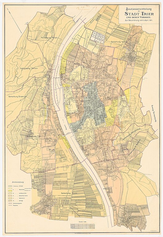
Bauklasseneinteilung der Stadt Trier und deren Vororte. Zur Bauordnung vom 6. April 1911. (Titel der Karte) Die Karte stellt die Situation in Trier ungefähr im Jahr 1909 dar. Architekt Hermann Jansen führte sie in den Jahren 1925/26 im Rahmen eines Wettbewerbs zur Bebauung von Trier-Heiligkreuz in seinen Unterlagen. |
Date |
circa 1909 date QS:P,+1909-00-00T00:00:00Z/9,P1480,Q5727902 (Kartendaten) / 1925/26 (Slg. Jansen) |
Source | Architekturmuseum TU Berlin (https://architekturmuseum.ub.tu-berlin.de/P/153069.php) / Hermann Jansen |
Author | Kunst- und Verlagsanstalt Schaar & Dathe, Trier |
Licensing
[edit]Public domainPublic domainfalsefalse |
![]() |
This work has been released into the public domain by its author, Architekturmuseum TU Berlin. This applies worldwide. In some countries this may not be legally possible; if so: Architekturmuseum TU Berlin grants anyone the right to use this work for any purpose, without any conditions, unless such conditions are required by law. Public domainPublic domainfalsefalse |
File history
Click on a date/time to view the file as it appeared at that time.
Date/Time | Thumbnail | Dimensions | User | Comment | |
---|---|---|---|---|---|
current | 07:10, 29 June 2021 | ![]() | 2,062 × 3,000 (2.82 MB) | P170 (talk | contribs) | =={{int:filedesc}}== {{Information |Description= |Source=Architekturmuseum TU Berlin (https://architekturmuseum.ub.tu-berlin.de/P/153069.php) / Hermann Jansen |Date={{other date|ca|1909}} (Kartendaten) / 1925/26 (Slg. Jansen) |Author=Kunst- und Verlagsanstalt Schaar & Dathe, Trier |Permission= |other_versions= }} =={{int:license-header}}== {{PD-author|Architekturmuseum TU Berlin}} Category:Maps of Trier |
You cannot overwrite this file.
File usage on Commons
There are no pages that use this file.
Metadata
This file contains additional information such as Exif metadata which may have been added by the digital camera, scanner, or software program used to create or digitize it. If the file has been modified from its original state, some details such as the timestamp may not fully reflect those of the original file. The timestamp is only as accurate as the clock in the camera, and it may be completely wrong.
Image title | Jansen Hermann (1869-1945), Wettbewerb Bebauungsplan für Heiligkreuz, Trier: Planungsunterlage: Karte der Stadt Trier mit Bauklasseneinteilung 1:1500, Maßstabsleiste. Buntstift über Lithographie farbig auf Papier, 119,50 x 82,00 cm (inkl. Scanrand). Architekturmuseum der Technischen Universität Berlin Inv. Nr. 21315. |
---|---|
Headline | Jansen Hermann (1869-1945): Wettbewerb Bebauungsplan für Heiligkreuz, Trier |
Author | Urheber des abgebildeten Werkes, Jansen Hermann (1869-1945) |
Credit/Provider | Architekturmuseum der Technischen Universität Berlin, Straße des 17. Juni 152, 10623 Berlin, Germany |
Source | Digitalisat von Druck Einzeichnung (Sammlungsbestand Bestand Architekturmuseum der Technischen Universität Berlin) |
Short title | Jansen Hermann (1869-1945): Wettbewerb Bebauungsplan für Heiligkreuz, Trier |
Copyright holder | (c) Architekturmuseum der Technischen Universität Berlin |
Online copyright statement | http://www.ub.tu-berlin.de/architekturmuseum |
IIM version | 2 |
Writer | Architekturmuseum der Technischen Universität Berlin |
Special instructions | Natives Farbprofil: ECI-RGB (http://www.eci.org). Als JPEG in sRGB IEC61966-2.1 konvertiert. |
Original transmission location code | Cruse MU. Gescannt 20070716 / verarbeitet 22.08.12 im Rahmen des DFG-Projekts DIGIPLAN. |
Keywords |
|
Horizontal resolution | 300 dpi |
Vertical resolution | 300 dpi |
Image width | 9,930 px |
Image height | 14,444 px |
Software used | Adobe Photoshop CS2 Windows |
Date and time of digitizing | 06:42, 16 July 2007 |
File change date and time | 15:07, 25 July 2007 |
Date metadata was last modified | 15:07, 25 July 2007 |
Copyright status | Copyrighted |
Structured data
Items portrayed in this file
depicts
image/jpeg
7742c1be6d1b0e5b37c1fb5d0df049274d6b8afb
2,961,447 byte
3,000 pixel
2,062 pixel
Hidden category: