File:Bautzen Altstadt 60.jpg
Salta a la navegació
Salta a la cerca

Mida d'aquesta previsualització: 800 × 463 píxels. Altres resolucions: 320 × 185 píxels | 640 × 370 píxels | 1.024 × 592 píxels | 1.280 × 741 píxels | 2.560 × 1.481 píxels | 5.427 × 3.140 píxels.
Fitxer original (5.427 × 3.140 píxels, mida del fitxer: 14,36 Mo, tipus MIME: image/jpeg)
Llegendes
Llegendes
Afegeix una explicació d'una línia del que representa aquest fitxer
Resum
[modifica]| Descripció |
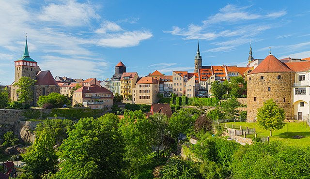
English: From Peace Bridge (Friedensbrücke) one has a great view of the old town of Bautzen, Landkreis Bautzen, Saxony, Germany. The depicted buildings are, among others, St Michael's Church (Michaeliskirche), Bautzen Cathedral (Dom St. Petri), the water tower (Wasserturm) and the tower of the Röhrscheidt Roundel Bastion (Röhrscheidtbastei).
Deutsch: Von der Friedensbrücke aus hat man einen vorzüglichen Blick auf die Altstadt von Bautzen, Landkreis Bautzen, Sachsen, Deutschland. Die abgebildeten Gebäude sind unter anderem Michaeliskirche, Dom St. Petri, Wasserturm und der Turm der Röhrscheidtbastei.
|
||||||||||||||||||||||||||
| Data | Taken on 3 de juny de 2020 | ||||||||||||||||||||||||||
| Font | Treball propi | ||||||||||||||||||||||||||
| Autor |
|
||||||||||||||||||||||||||
| Altres versions |
|
||||||||||||||||||||||||||


| Posició de la càmera | | Aquesta i altres imatges properes a: OpenStreetMap |
|---|
Notes
[modifica]
This image is not public domain. Please respect the copyright protection. It may only be used according to the rules mentioned here. This specifically excludes use in social media, if applicable terms of the licenses listed here not appropriate. (See for example CC BY-SA on Facebook.) Of course, a free license is no carte blanche for use. Especially there restrictions not based on the License, for example to the personality rights of the author. This is especially true for the required attribution and the use of the image. It is expressly not allowed to give the impression through the use of the image, that the author supports the work, in which the image is used, or whose rights holders in any way. |

| Please do not upload a modified image here without consultation with the author. The author would like to make possible minor modifications only at his own source. (The source is usually a RAW file. Processing of the JPEG file means a loss of quality.) This ensures that the changes and the quality are preserved. Please if you think that any changes should be required, please contact the author. Otherwise you can upload a new image with a new name. Please use one of the templates derivative or extract. Please enter your name too, if you upload a derivative or a detail, because you're in charge of the changes. Please do not rename this file. The name is part of the attribution. In the case of misstatements, the author is pleased to provide information. |
Llicència
[modifica]
Jo, el titular dels drets d'autor d'aquest treball, el public sota la següent llicència:
This file is licensed under the Creative Commons Attribution-Share Alike 4.0 International license.
- Sou lliure de:
- compartir – copiar, distribuir i comunicar públicament l'obra
- adaptar – fer-ne obres derivades
- Amb les condicions següents:
- reconeixement – Heu de donar la informació adequada sobre l'autor, proporcionar un enllaç a la llicència i indicar si s'han realitzat canvis. Podeu fer-ho amb qualsevol mitjà raonable, però de cap manera no suggereixi que l'autor us dóna suport o aprova l'ús que en feu.
- compartir igual – Si modifiqueu, transformeu, o generareu amb el material, haureu de distribuir les vostres contribucions sota una llicència similar o una de compatible com l'original

|
Aquesta imatge ha estat carregada en el marc de Wiki Loves Monuments 2020.
|
| Anotacions | Aquesta imatge té anotacions: Vegeu-les a Commons |
Historial del fitxer
Cliqueu una data/hora per veure el fitxer tal com era aleshores.
| Data/hora | Miniatura | Dimensions | Usuari/a | Comentari | |
|---|---|---|---|---|---|
| actual | 19:25, 30 set 2020 | | 5.427 × 3.140 (14,36 Mo) | J.-H. Janßen (discussió | contribucions) | {{Information |Description ={{en|1=From Peace Bridge (''Friedensbrücke'') one has a great view of the old town of Bautzen, Landkreis Bautzen, Saxony, Germany. The depicted buildings are, among others, St Michael's Church (''Michaeliskirche''), Bautzen Cathedral (''Dom St. Petri''), the water tower (''Wasserturm'') and the Röhrscheidt Roundel Bastion (''Röhrscheidtbastei'').}} {{de|1=Von der Friedensbrücke aus hat man einen vorzüglichen Blick auf die... |
No podeu sobreescriure aquest fitxer.
Ús del fitxer
Les 5 pàgines següents utilitzen aquest fitxer:
Ús global del fitxer
Utilització d'aquest fitxer en altres wikis:
- Utilització a ar.wikipedia.org
- Utilització a ba.wikipedia.org
- Utilització a ca.wikipedia.org
- Utilització a de.wikipedia.org
- Utilització a de.wikivoyage.org
- Utilització a eo.wikipedia.org
- Utilització a he.wikipedia.org
- Utilització a ro.wikipedia.org
- Utilització a uk.wikipedia.org
- Utilització a www.wikidata.org