File:Beauplan Poland XVII map.jpg
Faylın orijinalı (6.674 × 5.244 piksel, fayl həcmi: 25,99 MB, MIME növü: image/jpeg)
Captions
Captions
Xülasə[redaktə]
| İzah |
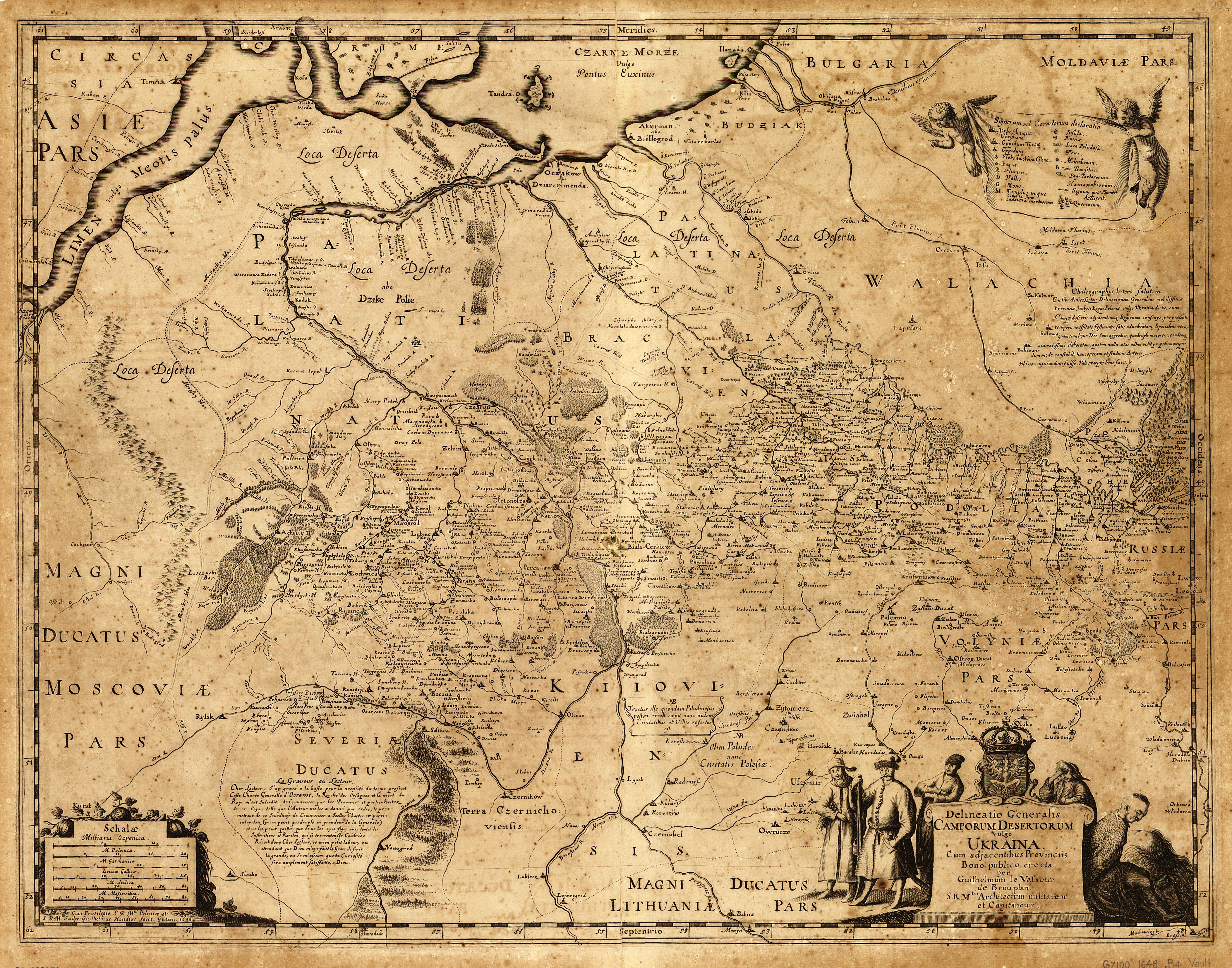
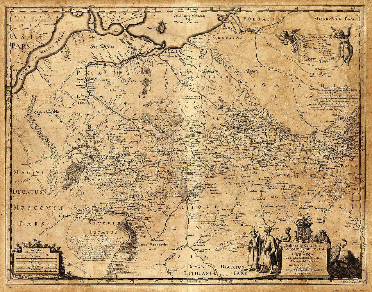
English: «Delineatio Generalis Camporum Desertorum vulgo Ukraina. Cum adjacentibus Provinciis».
Latina: Delineatio generalis Camporum Desertorum vulgo Ukraina: cum adjacentibus provinciis / bono publico erecta per Guilhelmum le Vasseur de Beauplan, S. R. M'tis architectum militarem et capitaneum ; sculpt. Guilhelmus Hondius fecit, Gedani, 1648.
Polski: Mapa Dzikich Pól inaczej Ukrainy, z przyległymi prowincjami. Sporządzona dla dobra publicznego przez Wilhelma de Beauplana w 1648 w Gdańsku na polecenie Władysława IV, Króla Polski
|
| Tarix | |
| Mənbə | Description de l'Ukrainie, qui sont plusieurs provinces du Royaume de Pologne, Contenuës depuis les confins de la Moscovie, jusques aux limites de la Transilvanie. Ensemble leurs moeurs, façcons de vivres et de faire la Guerre. Par le Sieur de Beauplan |
| Müəllif | Vasseur de Beauplan |
NOTES Scale ca. 1:1,750,000.
Relief shown pictorially.
Oriented with north to the bottom.
Includes text in Latin and French and ill.
SUBJECTS Ukraine--Maps--Early works to 1800. Ukraine.
RELATED NAMES Hondius, Willem.
MEDIUM 1 map ; 43 x 55 cm.
CALL NUMBER G7100 1648 .B4 Vault
REPOSITORY Library of Congress Geography and Map Division Washington, D.C. 20540-4650 USA http://memory.loc.gov/cgi-bin/query/h?ammem/gmd:@field%28NUMBER+@band%28g7100+ct000383%29%29
Lisenziya[redaktə]
|
This work is in the public domain in its country of origin and other countries and areas where the copyright term is the author's life plus 100 years or fewer. This work is in the public domain in the United States because it was published (or registered with the U.S. Copyright Office) before January 1, 1929. | |
| This file has been identified as being free of known restrictions under copyright law, including all related and neighboring rights. | |
Faylın tarixçəsi
Faylın əvvəlki versiyasını görmək üçün gün/tarix bölməsindəki tarixlərə klikləyin.
| Tarix/Vaxt | Kiçik şəkil | Ölçülər | İstifadəçi | Şərh | |
|---|---|---|---|---|---|
| indiki | 12:10, 15 iyun 2014 | | 6.674 × 5.244 (25,99 MB) | Gerodian (müzakirə | töhfələr) | Карта с большим разрешением и в лучшем качестве |
| 13:51, 13 oktyabr 2013 |  | 3.000 × 2.357 (2,52 MB) | Andros64 (müzakirə | töhfələr) | better quality | |
| 10:02, 24 yanvar 2011 |  | 3.000 × 2.357 (1,95 MB) | Bornholm (müzakirə | töhfələr) | {{Information |Description ={{en|1=The map Kingdom of Poland (es. "Wild Fields") near the Black Sea from 17 c. made on order King of Poland Władysław IV Vasa by Guillaume le Vasseur de Beauplan. Original latin name: Delineatio generalis Camporum Dese |
Siz bu faylı yenidən yükləyə bilməzsiniz.
Fayl keçidləri
Aşağıdakı səhifə bu faylı istifadə edir:
Faylın qlobal istifadəsi
Bu fayl aşağıdakı vikilərdə istifadə olunur:
- ar.wikipedia.org layihəsində istifadəsi
- az.wikipedia.org layihəsində istifadəsi
- be-tarask.wikipedia.org layihəsində istifadəsi
- ca.wikipedia.org layihəsində istifadəsi
- ce.wikipedia.org layihəsində istifadəsi
- cs.wikipedia.org layihəsində istifadəsi
- de.wikipedia.org layihəsində istifadəsi
- en.wikipedia.org layihəsində istifadəsi
- es.wikipedia.org layihəsində istifadəsi
- et.wikipedia.org layihəsində istifadəsi
- fr.wikipedia.org layihəsində istifadəsi
- it.wikipedia.org layihəsində istifadəsi
- la.wikipedia.org layihəsində istifadəsi
- lt.wikipedia.org layihəsində istifadəsi
- nl.wikipedia.org layihəsində istifadəsi
- pl.wikipedia.org layihəsində istifadəsi
- ro.wikipedia.org layihəsində istifadəsi
- ru.wikipedia.org layihəsində istifadəsi
Bu faylın qlobal istifadəsinə baxın.