File:Benelux schematic map.svg
跳至導覽
跳至搜尋

此 SVG 檔案的 PNG 預覽的大小:430 × 500 像素。 其他解析度:206 × 240 像素 | 413 × 480 像素 | 660 × 768 像素 | 881 × 1,024 像素 | 1,761 × 2,048 像素。
原始檔案 (SVG 檔案,表面大小:430 × 500 像素,檔案大小:20 KB)
說明
說明
添加單行說明來描述出檔案所代表的內容
摘要
[編輯]| 描述 |
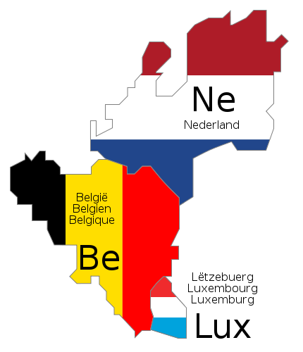
Deutsch: Schematische Karte der Benelux-Länder. Die Länderbezeichnungen sind jeweils in den offiziellen Landessprachen angegeben.
English: Schematic map of Benelux. The country names are given in the official languages of each state.
Français : Carte schématique du Benelux. Les noms des pays sont indiqués dans les langues officielles respectives de chaque état.
Nederlands: Schematische kaart van de Benelux. De landsnamen worden weergegeven in de officiële taal of talen van het betreffende land. |
||||||||
| 日期 | |||||||||
| 來源 | 自己的作品. The schematic design is derived from Benelux.png (released under GFDL), and the flag colors were taken from Flag of Belgium.svg, Flag of Luxembourg.svg and Flag of the Netherlands.svg (both PD) | ||||||||
| 作者 |
|
||||||||
| 授權許可 (重用此檔案) |
|
||||||||
| 其他版本 |
|
||||||||
| SVG開發 |


檔案歷史
點選日期/時間以檢視該時間的檔案版本。
| 日期/時間 | 縮圖 | 尺寸 | 用戶 | 備註 | |
|---|---|---|---|---|---|
| 目前 | 2009年6月17日 (三) 10:46 | | 430 × 500(20 KB) | Bibi Saint-Pol(對話 | 貢獻) | fix internal trouble with text nodes |
| 2009年6月17日 (三) 10:28 |  | 430 × 500(21 KB) | Bibi Saint-Pol(對話 | 貢獻) | {{inkscape}} {{Information |Description= {{en|1=Schematic map of w:en:Benelux. The country names are given in the official languages of each state.}} {{fr|1=Carte schématique du w:fr:Benelux. Les noms des pays sont indiqués dans les langues of |
無法覆蓋此檔案。
檔案用途
下列3個頁面有用到此檔案:
全域檔案使用狀況
以下其他 wiki 使用了這個檔案:
- de.wikipedia.org 的使用狀況
- ko.wikipedia.org 的使用狀況
- ru.wikipedia.org 的使用狀況
- uz.wikipedia.org 的使用狀況
- zh.wikipedia.org 的使用狀況