File:Beringia land bridge-noaagov.gif
Skočit na navigaci
Skočit na vyhledávání
Větší rozlišení není k dispozici.
Beringia_land_bridge-noaagov.gif (700 × 458 pixelů, velikost souboru: 367 KB, MIME typ: image/gif, ve smyčce, 22 snímků, 24 s)
Popisky
Popisky
Přidejte jednořádkové vysvětlení, co tento soubor představuje
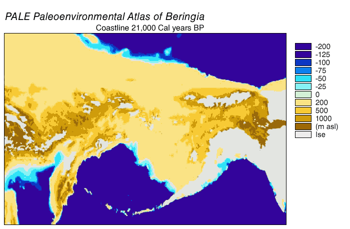
Animated gif of Beringia Land Bridge
| Popis | Beringia Land Bridge. Animated gif of its progress from 21.000 BP (before present) to modern times. See also: Bering Strait |
| Datum | |
| Zdroj | http://www.ncdc.noaa.gov/paleo/parcs/atlas/beringia/lbridge.html |
| Autor | NOAA |
| Svolení (Užití tohoto souboru) |
PD-USGov-NOAA |
| Další verze | http://www.ncdc.noaa.gov/paleo/parcs/atlas/beringia/lbridge.html |
Tento obrázek je volné dílo, protože obsahuje materiály, které pochází z amerického Národního úřadu pro oceán a atmosféru a byly pořízeny nebo vytvořeny během výkonu pracovní náplně jeho zaměstnanců.
|
Historie souboru
Kliknutím na datum a čas se zobrazí tehdejší verze souboru.
| Datum a čas | Náhled | Rozměry | Uživatel | Komentář | |
|---|---|---|---|---|---|
| současná | 9. 8. 2015, 04:16 | | 700 × 458 (367 KB) | Leonid 2 (diskuse | příspěvky) | optimization |
| 4. 9. 2006, 11:52 |  | 700 × 458 (2,4 MB) | Roblespepe (diskuse | příspěvky) | {{Information |Description=Beringia Land Bridge. Animated gif of its progress from 21.000 BC to modern times |Source=http://www.ncdc.noaa.gov/paleo/parcs/atlas/beringia/lbridge.html |Date=1999 |Author=NOAA |Permission=PD-USGov-NOAA |other_versions=http:// |
Tento soubor nemůžete přepsat.
Využití souboru
Na Commons na soubor odkazují tyto stránky:
Globální využití souboru
Tento soubor využívají následující wiki:
- Využití na ar.wikipedia.org
- Využití na ast.wikipedia.org
- Využití na avk.wikipedia.org
- Využití na az.wikipedia.org
- Využití na be.wikipedia.org
- Využití na bg.wikipedia.org
- Využití na bn.wikipedia.org
- Využití na ca.wikipedia.org
- Využití na cs.wikipedia.org
- Využití na da.wikipedia.org
- Využití na de.wikipedia.org
- Využití na el.wikipedia.org
- Využití na en.wikipedia.org
- Beringia
- User:World History (Book)
- Talk:Indigenous peoples in Canada/Archive 1
- Wikipedia:Graphics Lab/Map workshop/Archive/Apr 2014
- Beringian wolf
- Pleistocene wolf
- Talk:History of South America/sandbox
- Evolution of the wolf
- Canadian Arctic tundra
- Peopling of the Americas
- User:Alpiniste17/sandbox
- Paleoshoreline
- User:AvaArdito/Paleoshoreline
- Talk:Clovis culture/Archive 1
- User:Generalissima/History of North America
- Využití na en.wikiversity.org
- Využití na eo.wikipedia.org
- Využití na es.wikipedia.org
Zobrazit další globální využití tohoto souboru.
Kategorie:
- English-language maps
- Animated maps of Northern Asia
- Animated maps of North America
- Bering Strait
- Maps of Siberia
- Pleistocene geography
- Last glacial maximum
- Maps of the history of North America
- Prehistoric Alaska
- Maps of the history of the United States
- Maps of the history of Russia
- Geological maps of Alaska
- Geography of Alaska
- Archaeology in North America
- Pre-Columbian trans-oceanic contact hypotheses
- Maps of the Bering Land Bridge
- Paleoenvironmental maps
- Pleistocene geology of Russia
- Pleistocene geology of Alaska