File:Beringia land bridge-noaagov.gif
پرش به ناوبری
پرش به جستجو
تفکیکپذیری بالاتری در دسترس نیست.
Beringia_land_bridge-noaagov.gif (۷۰۰ × ۴۵۸ پیکسل، اندازهٔ پرونده: ۳۶۷ کیلوبایت، نوع MIME پرونده: image/gif، چرخشدار، ۲۲ قاب، ۲۴ ثانیه)
گزینهها
عنوان
شرحی یکخطی از محتوای این فایل اضافه کنید
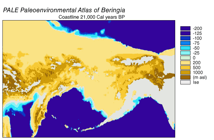
Animated gif of Beringia Land Bridge
| توضیح | Beringia Land Bridge. Animated gif of its progress from 21.000 BP (before present) to modern times. See also: Bering Strait |
| تاریخ | |
| منبع | http://www.ncdc.noaa.gov/paleo/parcs/atlas/beringia/lbridge.html |
| پدیدآور | NOAA |
| اجازهنامه (استفادهٔ مجدد از این پرونده) |
PD-USGov-NOAA |
| دیگر نسخهها | http://www.ncdc.noaa.gov/paleo/parcs/atlas/beringia/lbridge.html |
This image is in the public domain because it contains materials that originally came from the U.S. National Oceanic and Atmospheric Administration, taken or made as part of an employee's official duties.
|
تاریخچهٔ پرونده
روی تاریخ/زمانها کلیک کنید تا نسخهٔ مربوط به آن هنگام را ببینید.
| تاریخ/زمان | بندانگشتی | ابعاد | کاربر | توضیح | |
|---|---|---|---|---|---|
| کنونی | ۹ اوت ۲۰۱۵، ساعت ۰۴:۱۶ | | ۷۰۰ در ۴۵۸ (۳۶۷ کیلوبایت) | Leonid 2 (بحث | مشارکتها) | optimization |
| ۴ سپتامبر ۲۰۰۶، ساعت ۱۱:۵۲ |  | ۷۰۰ در ۴۵۸ (۲٫۴ مگابایت) | Roblespepe (بحث | مشارکتها) | {{Information |Description=Beringia Land Bridge. Animated gif of its progress from 21.000 BC to modern times |Source=http://www.ncdc.noaa.gov/paleo/parcs/atlas/beringia/lbridge.html |Date=1999 |Author=NOAA |Permission=PD-USGov-NOAA |other_versions=http:// |
شما نمیتوانید این پرونده را رونویسی کنید.
کاربرد پرونده
صفحههای زیر از این تصویر استفاده میکنند:
کاربرد سراسری پرونده
ویکیهای دیگر زیر از این پرونده استفاده میکنند:
- کاربرد در ar.wikipedia.org
- کاربرد در ast.wikipedia.org
- کاربرد در avk.wikipedia.org
- کاربرد در az.wikipedia.org
- کاربرد در be.wikipedia.org
- کاربرد در bg.wikipedia.org
- کاربرد در bn.wikipedia.org
- کاربرد در ca.wikipedia.org
- کاربرد در cs.wikipedia.org
- کاربرد در da.wikipedia.org
- کاربرد در de.wikipedia.org
- کاربرد در el.wikipedia.org
- کاربرد در en.wikipedia.org
- Beringia
- User:World History (Book)
- Talk:Indigenous peoples in Canada/Archive 1
- Wikipedia:Graphics Lab/Map workshop/Archive/Apr 2014
- Beringian wolf
- Pleistocene wolf
- Talk:History of South America/sandbox
- Evolution of the wolf
- Canadian Arctic tundra
- Peopling of the Americas
- User:Alpiniste17/sandbox
- Paleoshoreline
- User:AvaArdito/Paleoshoreline
- Talk:Clovis culture/Archive 1
- User:Generalissima/History of North America
- کاربرد در en.wikiversity.org
- کاربرد در eo.wikipedia.org
- کاربرد در es.wikipedia.org
نمایش استفادههای سراسری از این پرونده.
ردهها:
- English-language maps
- Animated maps of Northern Asia
- Animated maps of North America
- Bering Strait
- Maps of Siberia
- Pleistocene geography
- Last glacial maximum
- Maps of the history of North America
- Prehistoric Alaska
- Maps of the history of the United States
- Maps of the history of Russia
- Geological maps of Alaska
- Geography of Alaska
- Archaeology in North America
- Pre-Columbian trans-oceanic contact hypotheses
- Maps of the Bering Land Bridge
- Paleoenvironmental maps
- Pleistocene geology of Russia
- Pleistocene geology of Alaska