File:Berlin-Rosenthal 1920.jpg
Jump to navigation
Jump to search
Size of this preview: 800 × 528 pixels. Other resolutions: 320 × 211 pixels | 640 × 423 pixels | 922 × 609 pixels.
Original file (922 × 609 pixels, file size: 235 KB, MIME type: image/jpeg)
Captions
Captions
Add a one-line explanation of what this file represents
Summary
[edit]
| Description |
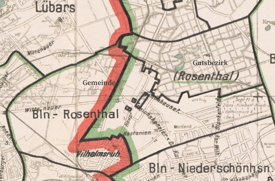
Deutsch: Gemeinde und Gutsbezirk Rosenthal in den Grenzen von 1920. In Grün/Rot die Bezirksgrenze zwischen Reinickendorf und Pankow ab 1920. |
| Date | |
| Source |
https://digital.zlb.de/viewer/resolver?urn=urn:nbn:de:kobv:109-1-15465651 Übersichtsplan der Stadt Berlin (Public Domain) Ausgabe 1, mit den kommunalen Grenzen von 1920 Digitalisat bei der Digitalen Landesbibliothek Berlin (digital.zlb.de) |
| Author | Zentralvermessungsamt Berlin |
Licensing
[edit]
This work is in the public domain in the United States because it was published (or registered with the U.S. Copyright Office) before January 1, 1929.
Public domain works must be out of copyright in both the United States and in the source country of the work in order to be hosted on the Commons. If the work is not a U.S. work, the file must have an additional copyright tag indicating the copyright status in the source country.
Note: This tag should not be used for sound recordings. |
File history
Click on a date/time to view the file as it appeared at that time.
| Date/Time | Thumbnail | Dimensions | User | Comment | |
|---|---|---|---|---|---|
| current | 16:29, 23 February 2024 | | 922 × 609 (235 KB) | Definitiv (talk | contribs) | Uploaded a work by Zentralvermessungsamt Berlin from https://digital.zlb.de/viewer/resolver?urn=urn:nbn:de:kobv:109-1-15465651 Übersichtsplan der Stadt Berlin (Public Domain) Ausgabe 1, mit den kommunalen Grenzen von 1920 Digitalisat bei der Digitalen Landesbibliothek Berlin (digital.zlb.de) with UploadWizard |
You cannot overwrite this file.
File usage on Commons
There are no pages that use this file.
File usage on other wikis
The following other wikis use this file:
- Usage on de.wikipedia.org