File:Beschreibvng des hochloblichen Fvrsten t.h v.b Obern vnd Nidern Bayrn - Kungliga Biblioteket - 10391328-thumb.png
Jump to navigation
Jump to search

Size of this preview: 568 × 599 pixels. Other resolutions: 228 × 240 pixels | 455 × 480 pixels | 728 × 768 pixels | 971 × 1,024 pixels | 1,942 × 2,048 pixels | 9,597 × 10,121 pixels.
Original file (9,597 × 10,121 pixels, file size: 472.54 MB, MIME type: image/png)
Captions
Captions
Add a one-line explanation of what this file represents
| Warning | The original file is very high-resolution. It might not load properly or could cause your browser to freeze when opened at full size. |
|---|
| Title |
|
||||||||||||||||||||||||||
| Description |
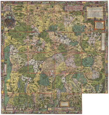
Svenska: "Ekonomisk karta" över Bayern som skulle ge Hertig Albrecht en bild av hans furstedöme. - Schematisk topografi. - Orter, industrier och gruvor utsatta. - Inramad av en praktfull renässansram med broskornamentik, groteskerier, kranier och andra vanitas-symboler |
||||||||||||||||||||||||||
| Source |
Png version of the 2GB tiff at the library (to big to upload here)
|
||||||||||||||||||||||||||
| Creator |
Petrus Weiner (creator, engraver) |
||||||||||||||||||||||||||
| Permission (Reusing this file) |
Per the source the digitisations are under
|
||||||||||||||||||||||||||
| Geotemporal data | |||||||||||||||||||||||||||
| Date depicted | 16th century | ||||||||||||||||||||||||||
| Map location |
Svenska: Bayern |
||||||||||||||||||||||||||
| Scale | 1:130,000 | ||||||||||||||||||||||||||
| Bounding box |
|
||||||||||||||||||||||||||
| Georeferencing | If inappropriate please set warp_status = skip to hide. | ||||||||||||||||||||||||||
| Bibliographic data | |||||||||||||||||||||||||||
| Map sheet | 1 karta på 24 ark | ||||||||||||||||||||||||||
| Language | Latin | ||||||||||||||||||||||||||
| Archival data | |||||||||||||||||||||||||||
| Collection |
|
||||||||||||||||||||||||||
| Accession number |
10391328 |
||||||||||||||||||||||||||
| Dimensions | 168 x 164 cm på ark 42 x 53 cm | ||||||||||||||||||||||||||
| Medium | kopparstick, handkolorerat, på pergament | ||||||||||||||||||||||||||
| Notes |
P.W.
|
||||||||||||||||||||||||||

File history
Click on a date/time to view the file as it appeared at that time.
| Date/Time | Thumbnail | Dimensions | User | Comment | |
|---|---|---|---|---|---|
| current | 15:07, 23 January 2015 | | 9,597 × 10,121 (472.54 MB) | L PBot (talk | contribs) | {{subst:User:André_Costa_(WMSE)/KB-map |title = * Beschreibvng des hochloblichen Fvrsten t:h v:b Obern vnd Nidern Bayrn * Chorographia Bavariæ * Beschreibung des hochloblichen Fürstentum Ober- und Nidernbayern |description = {{sv|"Ek... |
You cannot overwrite this file.
File usage on Commons
The following 5 pages use this file: