File:Bethel Alaska aerial view.jpg
跳转到导航
跳转到搜索

本预览的尺寸:641 × 599像素。 其他分辨率:257 × 240像素 | 513 × 480像素 | 821 × 768像素 | 1,095 × 1,024像素 | 1,493 × 1,396像素。
原始文件 (1,493 × 1,396像素,文件大小:843 KB,MIME类型:image/jpeg)
说明
说明
添加一行文字以描述该文件所表现的内容
摘要
[编辑]
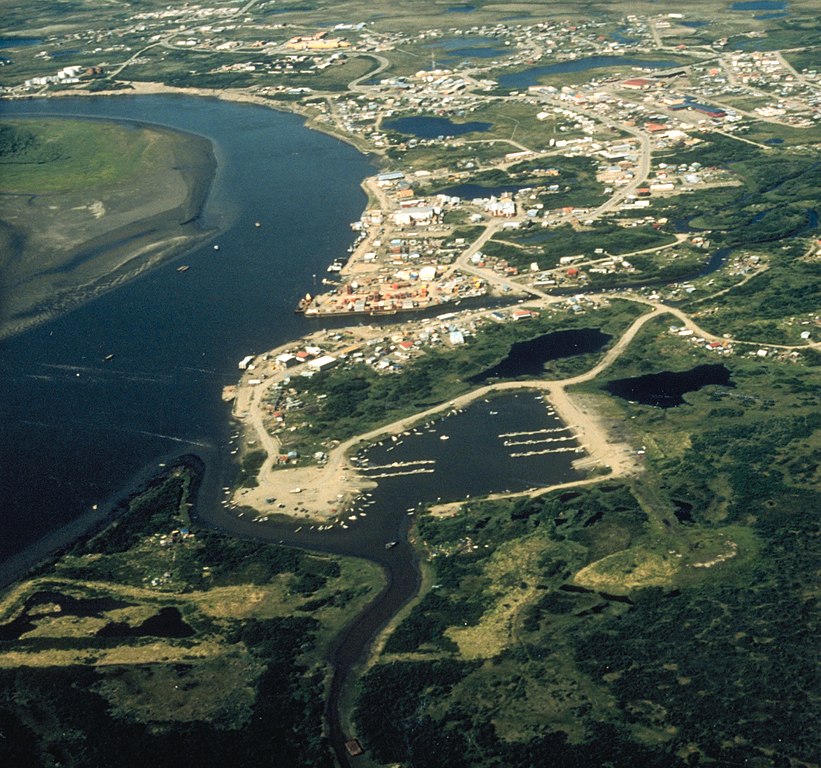
| 描述 | Aerial view of Bethel, Alaska. |
| 日期 | not specified or unknown |
| 来源 |
U.S. Army Corps of Engineers Digital Visual Library
|
| 作者 | U.S. Army Corps of Engineers, photographer not specified or unknown |
| 授权 (二次使用本文件) |
Public Domain |
| 物体位置 | | 在以下服务上查看本图像和附近其他图像: OpenStreetMap |
|---|
许可协议
[编辑]
This image or file is a work of a U.S. Army Corps of Engineers soldier or employee, taken or made as part of that person's official duties. As a work of the U.S. federal government, the image is in the public domain.
|
文件历史
点击某个日期/时间查看对应时刻的文件。
| 日期/时间 | 缩略图 | 大小 | 用户 | 备注 | |
|---|---|---|---|---|---|
| 当前 | 2017年6月10日 (六) 22:13 | | 1,493 × 1,396(843 KB) | Kingofthedead(留言 | 贡献) | Cropped < 1 % horizontally using CropTool with precise mode. |
| 2007年3月20日 (二) 01:53 |  | 1,500 × 1,396(798 KB) | DanMS(留言 | 贡献) | {{Information | Description = Aerial view of Bethel, Alaska. | Source = U.S. Army Corps of Engineers Digital Visual Library<br />[http://images.usace.army.mil/images/Hires/4414-21.Jpg Image page]<br />[http://images.usace.army.mil/scripts/PortW |
您不可以覆盖此文件。
文件用途
以下3个页面使用本文件:
全域文件用途
以下其他wiki使用此文件:
- af.wikipedia.org上的用途
- ar.wikipedia.org上的用途
- arz.wikipedia.org上的用途
- azb.wikipedia.org上的用途
- az.wikipedia.org上的用途
- ceb.wikipedia.org上的用途
- de.wikipedia.org上的用途
- en.wikipedia.org上的用途
- en.wikivoyage.org上的用途
- fa.wikipedia.org上的用途
- fr.wikipedia.org上的用途
- ga.wikipedia.org上的用途
- he.wikipedia.org上的用途
- incubator.wikimedia.org上的用途
- io.wikipedia.org上的用途
- it.wikipedia.org上的用途
- ja.wikipedia.org上的用途
- ko.wikipedia.org上的用途
- mdf.wikipedia.org上的用途
- ml.wikipedia.org上的用途
- mrj.wikipedia.org上的用途
- nl.wikipedia.org上的用途
- pl.wikipedia.org上的用途
- pt.wikipedia.org上的用途
- ru.wikipedia.org上的用途
- sd.wikipedia.org上的用途
- sh.wikipedia.org上的用途
- simple.wikipedia.org上的用途
- sr.wikipedia.org上的用途
- tly.wikipedia.org上的用途
- tr.wikipedia.org上的用途
- tum.wikipedia.org上的用途
- uk.wikipedia.org上的用途
- uz.wikipedia.org上的用途
- vo.wikipedia.org上的用途
- www.wikidata.org上的用途
- zh-min-nan.wikipedia.org上的用途
- zh.wikipedia.org上的用途
- zh.wikivoyage.org上的用途