File:Bgiusca Jirecek Line.jpg
跳至導覽
跳至搜尋
無更高解析度可提供。
Bgiusca_Jirecek_Line.jpg (614 × 561 像素,檔案大小:176 KB,MIME 類型:image/jpeg)
說明
說明
添加單行說明來描述出檔案所代表的內容
| 描述 |
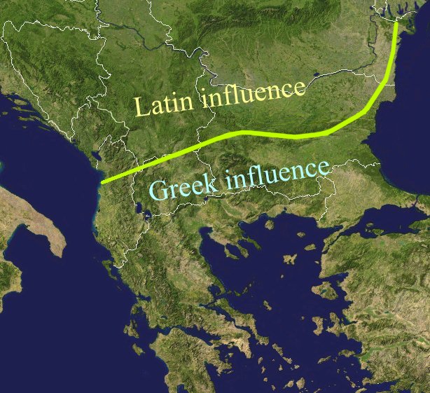
The Jirecek Line, which divides the kind of archaeological findings: to the north of the line most of the inscriptions are in Latin, to the south, they are in Greek. Aegyssos, Argamum, Histria, Tomis & Kallatis cities had greek and latin inscriptions until the VIIth cen. after JC. Jireček claimed that this line represents The division between the Greek and the Latin influence in the Balkans during the Roman Empire |
| 日期 | |
| 來源 | Public domain NASA image via worldwind |
| 作者 | Bogdan Giuşcă |
| 授權許可 (重用此檔案) |
GFDL |

|
已授權您依據自由軟體基金會發行的無固定段落、封面文字和封底文字GNU自由文件授權條款1.2版或任意後續版本,對本檔進行複製、傳播和/或修改。該協議的副本列在GNU自由文件授權條款中。 |
| 此檔案採用創用CC 姓名標示-相同方式分享 3.0 未在地化版本授權條款。 | ||
| ||
| 已新增授權條款標題至此檔案,作為GFDL授權更新的一部份。 |
檔案歷史
點選日期/時間以檢視該時間的檔案版本。
| 日期/時間 | 縮圖 | 尺寸 | 使用者 | 備註 | |
|---|---|---|---|---|---|
| 目前 | 2022年2月23日 (三) 01:27 | | 614 × 561(176 KB) | Demetrios1993(留言 | 貢獻) | The initial version by User:Bogdan had it correct, but later, the western section of the line was altered without any justification. |
| 2018年3月25日 (日) 10:01 |  | 614 × 561(249 KB) | Trecătorul răcit(留言 | 貢獻) | Antic shoreline and correct present-day borders | |
| 2014年8月7日 (四) 10:50 |  | 614 × 561(250 KB) | Spiridon Ion Cepleanu(留言 | 貢獻) | According with Jirecek's works and the palaeography of Aegyssos, Argamum, Histria, Tomis & Kallatis cities (greek and latin inscriptions until the VIIth cen. after JC) | |
| 2005年4月19日 (二) 09:56 |  | 614 × 561(101 KB) | Bogdan(留言 | 貢獻) | The division between the Greek and the Latin influence in the Balkans during the Roman Empire Source: Public domain work {{GFDL}} Category:Romanian historyCategory:Roman Empire\ |
無法覆蓋此檔案。
檔案用途
下列4個頁面有用到此檔案:
全域檔案使用狀況
以下其他 wiki 使用了這個檔案:
- an.wikipedia.org 的使用狀況
- ar.wikipedia.org 的使用狀況
- ast.wikipedia.org 的使用狀況
- ba.wikipedia.org 的使用狀況
- bg.wikipedia.org 的使用狀況
- ca.wikipedia.org 的使用狀況
- ce.wikipedia.org 的使用狀況
- cs.wikipedia.org 的使用狀況
- cv.wikipedia.org 的使用狀況
- de.wikipedia.org 的使用狀況
- el.wikipedia.org 的使用狀況
- en.wikipedia.org 的使用狀況
- es.wikipedia.org 的使用狀況
- et.wikipedia.org 的使用狀況
- eu.wikipedia.org 的使用狀況
- fa.wikipedia.org 的使用狀況
- fr.wikipedia.org 的使用狀況
- he.wikipedia.org 的使用狀況
- hi.wikipedia.org 的使用狀況
- hr.wikipedia.org 的使用狀況
- id.wikipedia.org 的使用狀況
- it.wikipedia.org 的使用狀況
- ja.wikipedia.org 的使用狀況
- ka.wikipedia.org 的使用狀況
- ko.wikipedia.org 的使用狀況
- la.wikipedia.org 的使用狀況
- lt.wikipedia.org 的使用狀況
檢視此檔案的更多全域使用狀況。
詮釋資料
分類:
- History of Romania
- Maps of ancient Rome
- Maps of the Byzantine Empire
- Maps of Dacian tribes
- Maps of Romania
- Maps of the history of the ancient Balkans
- Konstantin Jireček
- Linguistic maps of the Latin language
- Linguistic maps of Europe
- NASA World Wind
- Linguistic maps of the Ancient Greek language
- English-language linguistic maps