File:Biafra independent state map-en.svg
跳至導覽
跳至搜尋

此 SVG 檔案的 PNG 預覽的大小:776 × 600 像素。 其他解析度:311 × 240 像素 | 621 × 480 像素 | 994 × 768 像素 | 1,280 × 989 像素 | 2,560 × 1,978 像素 | 1,100 × 850 像素。
原始檔案 (SVG 檔案,表面大小:1,100 × 850 像素,檔案大小:472 KB)
說明
說明
添加單行說明來描述出檔案所代表的內容
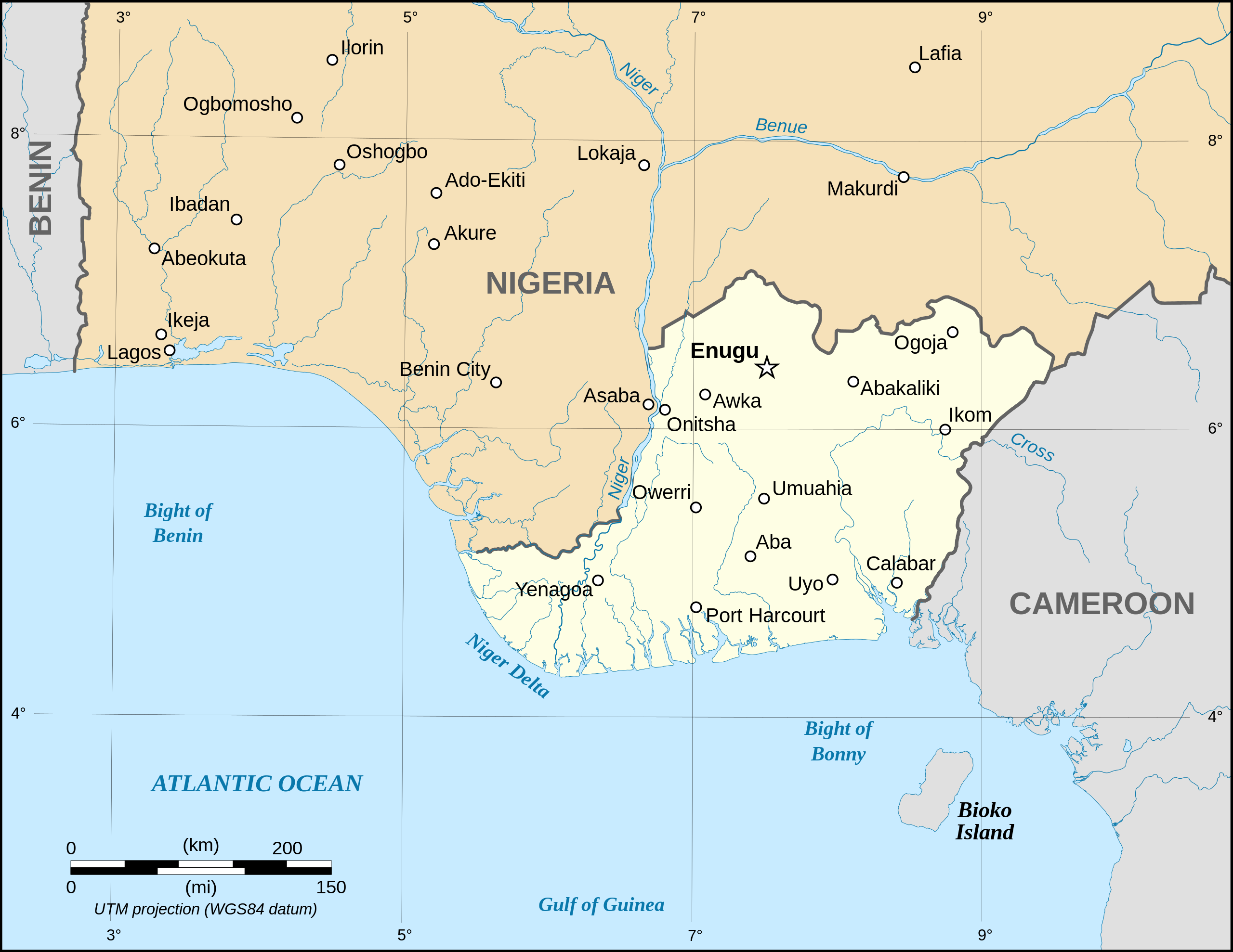
Map of the secessionist state of the Republic of Biafra (1967–1970) as in May 1967

|
This SVG file contains embedded text that can be translated into your language, using any capable SVG editor, text editor or the SVG Translate tool. For more information see: About translating SVG files. |
摘要
[編輯]| 描述 |
Català: Mapa de la república de Biafra en el maig 1967. English: Map of the secessionist state of the Republic of Biafra (1967 – 1970) as in May 1967. Note: The western boundary may not be accurate due to the low precision of the reference maps used which are also contradictory. Français : Carte en anglais de l'État sécessionniste de la République du Biafra (1967 – 1970) telle qu'en mai 1967. Note : La frontière Ouest peut ne pas être précise en raison de l'imprécision des cartes de référence qui sont aussi contradictoires. UTM projection ; WGS 84 datum |
||
| 日期 | September 2008 (new version) | ||
| 來源 |
Own work
|
||
| 作者 | Eric Gaba (Sting - fr:Sting) | ||
| 授權許可 (重用此檔案) |
|
||
| 其他版本 |
[]
|


|
|
This SVG file contains embedded text that can be translated into your language, using any capable SVG editor, text editor or the SVG Translate tool. For more information see: About translating SVG files. |
授權條款
[編輯]
我,本作品的著作權持有者,決定用以下授權條款發佈本作品:

|
已授權您依據自由軟體基金會發行的無固定段落、封面文字和封底文字GNU自由文件授權條款1.2版或任意後續版本,對本檔進行複製、傳播和/或修改。該協議的副本列在GNU自由文件授權條款中。 |
| 此檔案採用創用CC 姓名標示-相同方式分享 3.0 未在地化版本授權條款。 | ||
| ||
| 已新增授權條款標題至此檔案,作為GFDL授權更新的一部份。 |
您可以選擇您需要的授權條款。
檔案歷史
點選日期/時間以檢視該時間的檔案版本。
| 日期/時間 | 縮圖 | 尺寸 | 使用者 | 備註 | |
|---|---|---|---|---|---|
| 目前 | 2023年9月15日 (五) 19:21 | | 1,100 × 850(472 KB) | Glrx(留言 | 貢獻) | 256 kB workaround // Editing SVG source code using c:User:Rillke/SVGedit.js |
| 2023年9月15日 (五) 10:59 |  | 1,100 × 850(472 KB) | KajenCAT(留言 | 貢獻) | File uploaded using svgtranslate tool (https://svgtranslate.toolforge.org/). Added translation for ca. | |
| 2008年9月3日 (三) 04:51 |  | 1,100 × 850(455 KB) | Sting(留言 | 貢獻) | New version using the NGDC GSHHS and WDBII data ; new standard colors | |
| 2006年12月12日 (二) 17:54 |  | 1,100 × 850(163 KB) | Sting(留言 | 貢獻) | {{Information| |Description=Map of the secessionist state of the Republic of Biafra (1967 – 1970) |Source=Own work<br/>Background reference map : Microsoft Encarta atlas (1999 edition)<br/>Biafra independent state borders reference maps : [http://www.bi |
無法覆蓋此檔案。
檔案用途
下列15個頁面有用到此檔案:
- Atlas of Nigeria
- Biafra
- User:Magog the Ogre/Multilingual legend/2023 September 11-15
- User:Sting/Gallery: Regional maps
- File:Biafra independent state map-ar.svg
- File:Biafra independent state map-de.svg
- File:Biafra independent state map-en.svg
- File:Biafra independent state map-es.svg
- File:Biafra independent state map-fr.svg
- File:Biafra independent state map-it.svg
- File:Biafra independent state map-jp.svg
- File:Biafra independent state map-mk.svg
- File:Biafra independent state map-ru.svg
- File:Biafra map.PNG
- Template:Other versions/Biafra independent state map
全域檔案使用狀況
以下其他 wiki 使用了這個檔案:
- af.wikipedia.org 的使用狀況
- ar.wikipedia.org 的使用狀況
- ast.wikipedia.org 的使用狀況
- azb.wikipedia.org 的使用狀況
- az.wikipedia.org 的使用狀況
- be.wikipedia.org 的使用狀況
- bn.wikipedia.org 的使用狀況
- br.wikipedia.org 的使用狀況
- ca.wikipedia.org 的使用狀況
- cs.wikipedia.org 的使用狀況
- da.wikipedia.org 的使用狀況
- el.wikipedia.org 的使用狀況
- en.wikipedia.org 的使用狀況
- eo.wikipedia.org 的使用狀況
- es.wikipedia.org 的使用狀況
- et.wikipedia.org 的使用狀況
- eu.wikipedia.org 的使用狀況
- fa.wikipedia.org 的使用狀況
- fr.wikipedia.org 的使用狀況
- gl.wikipedia.org 的使用狀況
- ha.wikipedia.org 的使用狀況
- he.wikipedia.org 的使用狀況
- hu.wikipedia.org 的使用狀況
- hy.wikipedia.org 的使用狀況
- id.wikipedia.org 的使用狀況
- ig.wikipedia.org 的使用狀況
- io.wikipedia.org 的使用狀況
檢視此檔案的更多全域使用狀況。