File:Bird's eye view of LSST construction progress (rubin-dji-0039-0).jpg
Jump to navigation
Jump to search

Size of this preview: 800 × 600 pixels. Other resolutions: 320 × 240 pixels | 640 × 480 pixels | 1,024 × 768 pixels | 1,280 × 960 pixels | 2,560 × 1,920 pixels | 4,000 × 3,000 pixels.
Original file (4,000 × 3,000 pixels, file size: 3.08 MB, MIME type: image/jpeg)
Captions
Captions
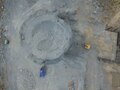
A DJI Phantom 3 Pro Drone is being used on Cerro Pachon to monitor LSST construction progress from an aerial birds-eye view. Multiple images will be used to generate a 3D model of the Summit Facility, suitable for inspection via virtual reality.
Summary
[edit]| Description |
English: A DJI Phantom 3 Pro Drone is being used on Cerro Pachon to monitor LSST construction progress from an aerial birds-eye view. Multiple images will be used to generate a 3D model of the Summit Facility, suitable for inspection via virtual reality. In these initial images taken by Systems Engineer Jaques Sebag, preparation of the telescope pier is clearly visible. From an altitude of 30 meters, closer to the actual height of the top of the dome, you can see the telescope pier emerging from the bedrock. |
| Date | 12 April 2017 (upload date) |
| Source | Bird's eye view of LSST construction progress |
| Author | Rubin Observatory/NSF/AURA |
| Other versions |
|
.jpg&action=edit§ion=1)
Licensing
[edit].jpg&action=edit§ion=2)
This media was created by the National Optical-Infrared Astronomy Research Laboratory (NOIRLab).
Their website states: "Unless specifically noted, the images, videos, and music distributed on the public NOIRLab website, along with the texts of press releases, announcements, images of the week and captions; are licensed under a Creative Commons Attribution 4.0 International License, and may on a non-exclusive basis be reproduced without fee provided the credit is clear and visible." To the uploader: You must provide a link (URL) to the original file and the authorship information if available. | |
This file is licensed under the Creative Commons Attribution 4.0 International license.
| |
File history
Click on a date/time to view the file as it appeared at that time.
| Date/Time | Thumbnail | Dimensions | User | Comment | |
|---|---|---|---|---|---|
| current | 22:48, 22 October 2023 | | 4,000 × 3,000 (3.08 MB) | OptimusPrimeBot (talk | contribs) | #Spacemedia - Upload of https://noirlab.edu/public/media/archives/images/large/rubin-dji-0039-0.jpg via Commons:Spacemedia |
You cannot overwrite this file.
File usage on Commons
The following page uses this file:
.jpg&oldid=909351346)