File:Blaisdell Arena, Ward Avenue and Kapiolani Boulevard, Kakaako, Honolulu, HI - 52263934326.jpg
Jump to navigation
Jump to search

Size of this preview: 800 × 600 pixels. Other resolutions: 320 × 240 pixels | 640 × 480 pixels | 1,024 × 768 pixels | 1,280 × 960 pixels | 2,560 × 1,920 pixels | 4,032 × 3,024 pixels.
Original file (4,032 × 3,024 pixels, file size: 3.43 MB, MIME type: image/jpeg)
Captions
Captions
Add a one-line explanation of what this file represents
Summary
[edit]
| Description |
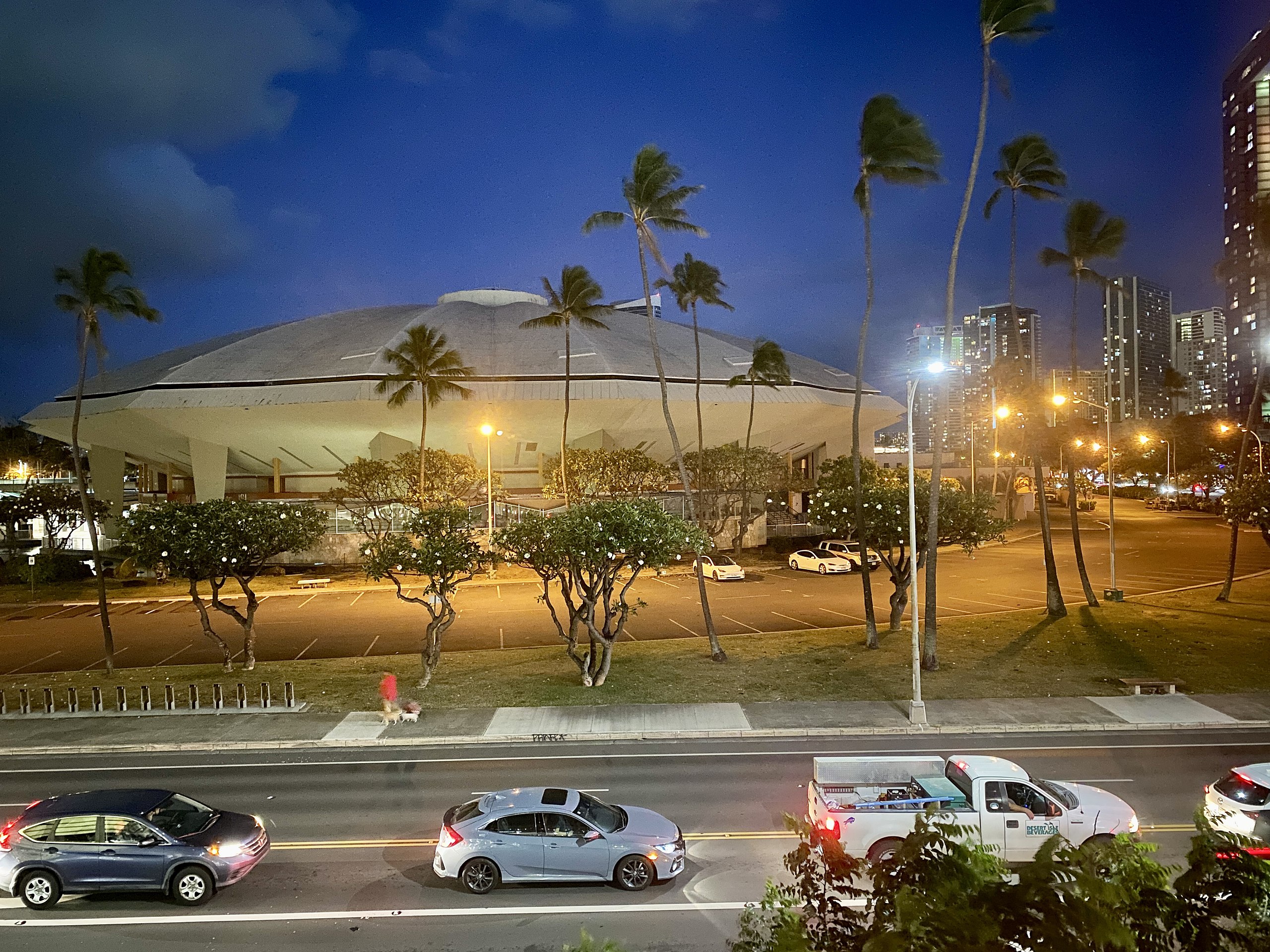
English: Completed in 1964, this Modern arena was designed by Adrian Wilson & Associates in conjunction with the master plan laid out by the firm Merril, Simms & Roehrig, and was known as the Honolulu International Center until 1976, when it was renamed in honor of former Honolulu Mayor Neil S. Blaisdell. The building features a Saarinen-esque sculptural exterior with a large clamshell-like domed roof made up of multiple segments that bends sharply at the edges of the building before curving underneath, forming a ceiling above the exterior concourse, tapered concrete columns at the exterior, one-story service wings in the front and rear with concrete butterfly roofs and columns, rustic stone cladding, and curtain walls on the upper portion of the exteriors, exterior staircases, a pond surrounding the rear and sides of the arena with a distinctive mid century modern sculpture that compliments the arena, and a breezeway connecting the arena to the adjacent Neal S. Blaisdell Convention Center. The arena, being one of the best examples of architecture inspired by the work of Eero Saarinen’s modern sculptural designs, is sadly endangered by a proposed renovation that would greatly alter the building’s concourses, adding a large glass curtain wall, removing the unique “mushroom”-like sculpture that sits in the pond behind the building, and completely obscure the tapered columns, as well as demolishing the service buildings that sit alongside the concourse. Additionally, the plans call for the demolition of the adjacent Neal S. Blaisdell Center and Blaisdell Concert Hall, irreparably harming the historic modern design of the concert hall and destroying what is left of the 1960s portion of the Blaisdell Center. Hopefully, a design far more sensitive to the original design of the modernist structures will be carried out. |
| Date | |
| Source | https://www.flickr.com/photos/59081381@N03/52263934326/ |
| Author | w_lemay |
| Camera location | | View this and other nearby images on: OpenStreetMap |
|---|
Licensing
[edit]
This file is licensed under the Creative Commons Attribution-Share Alike 2.0 Generic license.
- You are free:
- to share – to copy, distribute and transmit the work
- to remix – to adapt the work
- Under the following conditions:
- attribution – You must give appropriate credit, provide a link to the license, and indicate if changes were made. You may do so in any reasonable manner, but not in any way that suggests the licensor endorses you or your use.
- share alike – If you remix, transform, or build upon the material, you must distribute your contributions under the same or compatible license as the original.
| This image was originally posted to Flickr by w_lemay at https://flickr.com/photos/59081381@N03/52263934326. It was reviewed on 14 March 2023 by FlickreviewR 2 and was confirmed to be licensed under the terms of the cc-by-sa-2.0. |
File history
Click on a date/time to view the file as it appeared at that time.
| Date/Time | Thumbnail | Dimensions | User | Comment | |
|---|---|---|---|---|---|
| current | 20:54, 14 March 2023 | | 4,032 × 3,024 (3.43 MB) | Ser Amantio di Nicolao (talk | contribs) | Uploaded a work by w_lemay from https://www.flickr.com/photos/59081381@N03/52263934326/ with UploadWizard |
You cannot overwrite this file.
File usage on Commons
The following page uses this file:
File usage on other wikis
The following other wikis use this file:
- Usage on sv.wikipedia.org