File:Bodies on the battlefield at antietam.jpg
Aller à la navigation
Aller à la recherche

Taille de cet aperçu : 800 × 560 pixels. Autres résolutions : 320 × 224 pixels | 640 × 448 pixels | 1 024 × 717 pixels | 1 280 × 897 pixels | 2 560 × 1 793 pixels | 6 202 × 4 344 pixels.
Fichier d’origine (6 202 × 4 344 pixels, taille du fichier : 5,89 Mio, type MIME : image/jpeg)
Légendes
Légendes
Ajoutez en une ligne la description de ce que représente ce fichier
Description
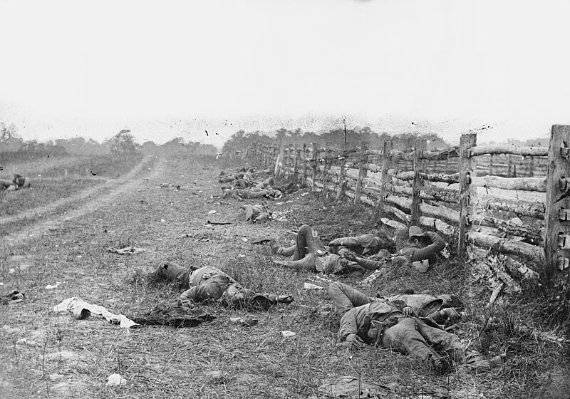
[modifier]| Alexander Gardner : corps après la bataille d'Antietam
|
||||||||||||||||||||||||||||
|---|---|---|---|---|---|---|---|---|---|---|---|---|---|---|---|---|---|---|---|---|---|---|---|---|---|---|---|---|
| Photographe |
|
 | ||||||||||||||||||||||||||
| Titre |
The Dead of Antietam |
|||||||||||||||||||||||||||
| Type d'objet |
photographie |
|||||||||||||||||||||||||||
| Genre |
photojournalisme |
|||||||||||||||||||||||||||
| Description |
Photograph of the field at Antietam, American Civil War. Confederate dead by a fence at the Hagerstown Turnpike, looking north; the Turnpike is to the right of the fence, the dirt lane on the left leads to the farm of David Miller. |
|||||||||||||||||||||||||||
| Date | Date de prise de vue : septembre 1862 | |||||||||||||||||||||||||||
| Références |
100 Photographs: The Most Influential Images of All Time |
|||||||||||||||||||||||||||
| Source |
|
|||||||||||||||||||||||||||
| Autorisation (Réutilisation de ce fichier) |
Public domain | |||||||||||||||||||||||||||


| Lieu de la prise de vue | | Voir cet endroit et d’autres images sur : OpenStreetMap |
|---|
Conditions d’utilisation
[modifier]
|
Cette œuvre est également dans le domaine public dans tous les pays pour lesquels le droit d’auteur a une durée de vie de 100 ans ou moins après la mort de l’auteur. Cette œuvre est dans le domaine public aux États-Unis car elle a été publiée avant le 1er janvier 1929. | |
| Ce fichier a été identifié comme étant exempt de restrictions connues liées au droit d’auteur, y compris tous les droits connexes et voisins. | |
Historique du fichier
Cliquer sur une date et heure pour voir le fichier tel qu'il était à ce moment-là.
| Date et heure | Vignette | Dimensions | Utilisateur | Commentaire | |
|---|---|---|---|---|---|
| actuel | 12 août 2013 à 22:29 | | 6 202 × 4 344 (5,89 Mio) | Ras67 (d | contributions) | high resolution |
| 13 mai 2011 à 22:36 |  | 838 × 587 (104 kio) | Cropbot (d | contributions) | upload cropped version, operated by User:Beao. Summary: cropped away burned edges | |
| 11 août 2005 à 15:47 |  | 971 × 728 (135 kio) | Shauni (d | contributions) | Photograph of the field at Antietam, American Civil War. From the Library of Congress' American Memory collection ORIGINAL LOCATION: http://memory.loc.gov/ndlpcoop/nhnycw/ad/ad18/ad18045v.jpg {{PD}} Category:American Civil War |
Vous ne pouvez pas remplacer ce fichier.
Utilisations locales du fichier
Les 8 pages suivantes utilisent ce fichier :
- User:Pfctdayelise/4by3splitaa
- User:Spinster/100 Photographs: The Most Influential Images of All Time
- User:Yann/FPC
- User:Yann/Favorites
- File:Antietam, Md. Confederate dead by a fence on the Hagerstown road LOC cwpb.01097.jpg
- File:Antietam, Md. Confederate dead by a fence on the Hagerstown road LOC cwpb.01097.tif
- File:Bodies on the battlefield at antietam.jpg
- File:The Dead of Antietam.jpg (redirection de fichier)
Utilisations du fichier sur d’autres wikis
Les autres wikis suivants utilisent ce fichier :
- Utilisation sur ar.wikipedia.org
- Utilisation sur ast.wikipedia.org
- Utilisation sur azb.wikipedia.org
- Utilisation sur az.wikipedia.org
- Utilisation sur ca.wikipedia.org
- Utilisation sur co.wikipedia.org
- Utilisation sur cs.wikipedia.org
- Utilisation sur da.wikipedia.org
- Utilisation sur de.wikipedia.org
- Utilisation sur en.wikipedia.org
- Battle of Antietam
- Military history of the United States
- Timeline of the history of the United States (1860–1899)
- Alexander Gardner (photographer)
- History of Maryland
- War photography
- Maryland in the American Civil War
- List of photographs considered the most important
- 2nd Louisiana Infantry Regiment (Confederate)
- User:Snowmanonahoe/List of photographs considered the most important
- Utilisation sur en.wikiquote.org
- Utilisation sur eo.wikipedia.org
- Utilisation sur es.wikipedia.org
- Utilisation sur fa.wikipedia.org
- Utilisation sur fy.wikipedia.org
- Utilisation sur he.wikipedia.org
- Utilisation sur hy.wikipedia.org
- Utilisation sur id.wikipedia.org
- Utilisation sur incubator.wikimedia.org
- Utilisation sur it.wikipedia.org
- Utilisation sur ja.wikipedia.org
Voir davantage sur l’utilisation globale de ce fichier.
Métadonnées
Catégories :
- September 1862 United States photographs
- Battle of Antietam
- Black and white photographs of corpses of men
- Black and white photographs of Maryland
- Black and white photographs of the United States in the 1860s
- Bodies of dead soldiers in the American Civil War
- Iconic photographs
- 1862 black and white photographs of people
- Photographs by Alexander Gardner