File:Bokan mountain locator USGS.JPG
跳转到导航
跳转到搜索

本预览的尺寸:476 × 599像素。 其他分辨率:191 × 240像素 | 631 × 794像素。
原始文件 (631 × 794像素,文件大小:81 KB,MIME类型:image/jpeg)
说明
说明
添加一行文字以描述该文件所表现的内容
摘要[编辑]
| 描述 |
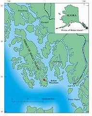
English: Map showing location of Bokan mountain on Prince of Wales Island, Alaska; inset shows location of island in Alaska. |
| 日期 | |
| 来源 | Environmental Studies of Mineral Deposits in Alaska U.S. GEOLOGICAL SURVEY BULLETIN 2156, UNITED STATES GOVERNMENT PRINTING OFFICE, WASHINGTON : 1996 |
| 作者 | John E. Gray and Richard F. Sanzolone (eds); graphics are credited to Richard P. Walker, Barbara Ramsey, and Carol A. Quesenberry |
许可协议[编辑]
|
|
文件历史
点击某个日期/时间查看对应时刻的文件。
| 日期/时间 | 缩略图 | 大小 | 用户 | 备注 | |
|---|---|---|---|---|---|
| 当前 | 2010年11月8日 (一) 21:15 | | 631 × 794(81 KB) | Dankarl(留言 | 贡献) | {{Information |Description={{en|1=Map showing location of Bokan mountain on Prince of Wales Island, Alaska; inset shows location of island in Alaska.}} |Source=Environmental Studies of Mineral Deposits in Alaska U.S. GEOLOGICAL SURVEY BULLETIN 2156, UNITE |
您不可以覆盖此文件。
文件用途
没有页面使用本文件。
全域文件用途
以下其他wiki使用此文件:
- it.wikipedia.org上的用途
- ja.wikipedia.org上的用途
- pl.wikipedia.org上的用途
- zh.wikipedia.org上的用途