File:Bolívia´s Titicaca lake at CBERS4 yesterday image.jpg
Jump to navigation
Jump to search
Size of this preview: 800 × 449 pixels. Other resolutions: 320 × 179 pixels | 640 × 359 pixels | 1,024 × 574 pixels | 1,280 × 718 pixels | 2,560 × 1,436 pixels | 5,373 × 3,013 pixels.
Original file (5,373 × 3,013 pixels, file size: 7.92 MB, MIME type: image/jpeg)
Captions
Captions
Add a one-line explanation of what this file represents
Summary[edit]
| Description |
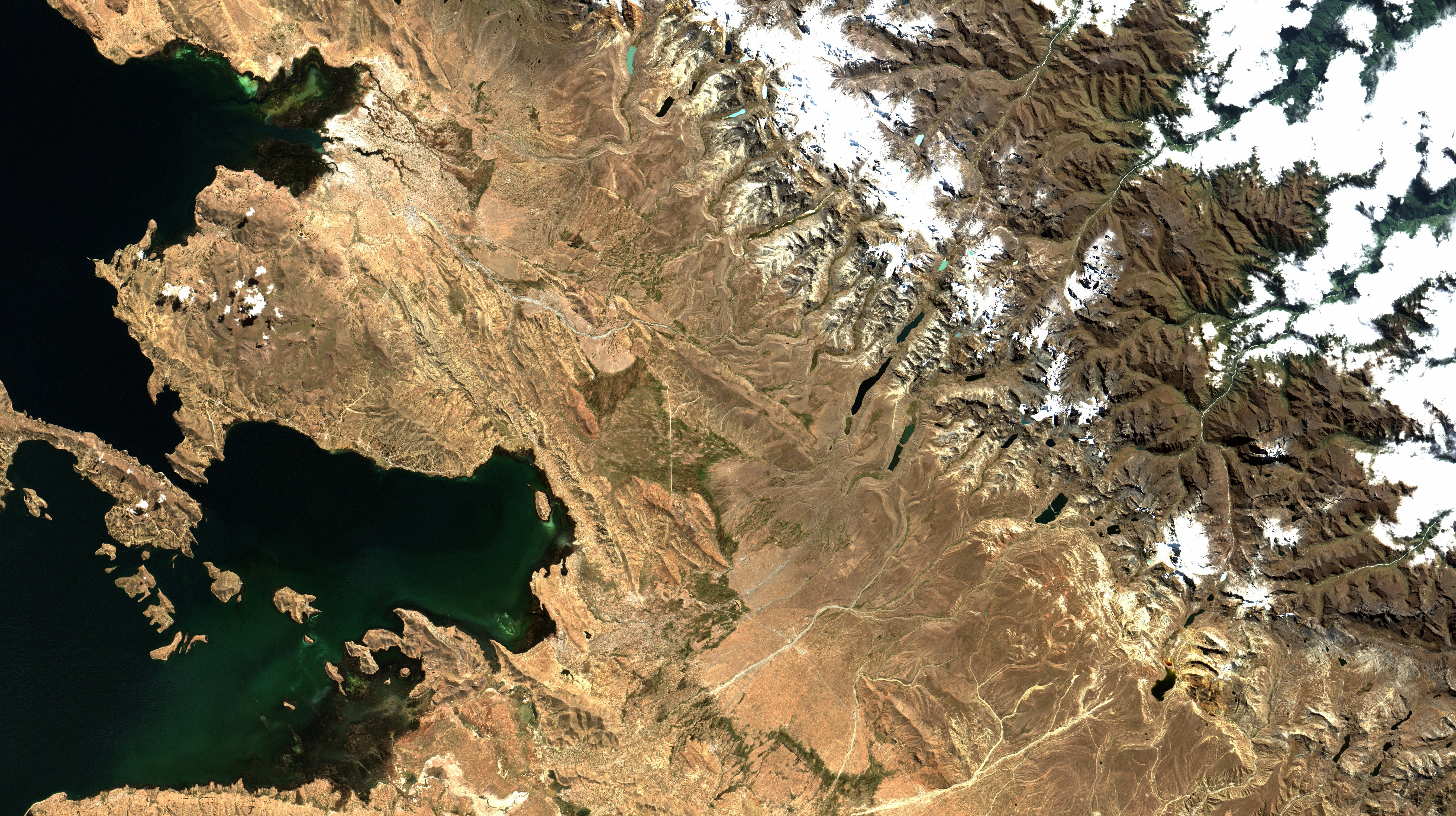
English: As águas do lago navegável mais alto do Mundo, a quase 4.000 m, aparecem em cor negra e verde escura. A Leste do lago, com alguma vegetação em verde, a Puna Úmida. Do centro da imagem à direita, a Cordilheira dos Andes, com neve em branco sobre sua áreas mais altas, com destaque para os Picos do Mich'ini, Condoriri e Huayna Potosí. Esse último, pico de alta montanha mais próximo de La Paz, com 6.088m, é muito usado por alpinistas iniciantes e para treinamentos. Também na cor branca, no alto à dir. da imagem, nuvens cobrem a região das Yungas, floresta temperada, no sopé da cordilheira, após os vales e quebradas / World´s highest navigable lake waters appear in black and dark green. Wet Puna, with some vegetation in green, is to the lake East. Andes Mountain Range is evidenced by its peaks snow, in white. Most known are Mich'ini, Condoriri e Huayna Potosí. Last one, with 20.000 ft and near La Paz, is used by beginner high mountain climbers for courses and practice. Also in white, at image upper right, clouds cover the Yungas, wet temperate forest at Andes base, just after "quebradas" valleys.
Imagem / Image CBERS4 MUX Coordenadas do centro da imagem / Image center: 16°09'56.6"S 68°29'06.4"W Data / Date: 20-05-2018 / 2018-20-05 RGB 765 (cor verdadeira / true color) Cena / Scene: 179/118 Autor / Author: Oton Barros (DSR/OBT/INPE) Imagem em HD / HD Image Visite-nos / Visit us: www.dsr.inpe.br |
| Date | |
| Source | https://www.flickr.com/photos/153282474@N02/27385998447/ |
| Author | Coordenação-Geral de Observação da Terra/INPE |
Licensing[edit]
This file is licensed under the Creative Commons Attribution-Share Alike 2.0 Generic license.
- You are free:
- to share – to copy, distribute and transmit the work
- to remix – to adapt the work
- Under the following conditions:
- attribution – You must give appropriate credit, provide a link to the license, and indicate if changes were made. You may do so in any reasonable manner, but not in any way that suggests the licensor endorses you or your use.
- share alike – If you remix, transform, or build upon the material, you must distribute your contributions under the same or compatible license as the original.
| This image was originally posted to Flickr by Coordenação-Geral de Observação da Terra/INPE at https://flickr.com/photos/153282474@N02/27385998447. It was reviewed on 9 April 2020 by FlickreviewR 2 and was confirmed to be licensed under the terms of the cc-by-sa-2.0. |
File history
Click on a date/time to view the file as it appeared at that time.
| Date/Time | Thumbnail | Dimensions | User | Comment | |
|---|---|---|---|---|---|
| current | 10:15, 9 April 2020 | | 5,373 × 3,013 (7.92 MB) | Jo-Jo Eumerus (talk | contribs) | Uploaded a work by Coordenação-Geral de Observação da Terra/INPE from https://www.flickr.com/photos/153282474@N02/27385998447/ with UploadWizard |
You cannot overwrite this file.
File usage on Commons
The following page uses this file:
.jpg&redirect=no)