File:Bono Archaeological Site.jpg
跳转到导航
跳转到搜索

本预览的尺寸:800 × 450像素。 其他分辨率:320 × 180像素 | 640 × 360像素 | 1,024 × 576像素 | 1,280 × 720像素 | 2,816 × 1,584像素。
原始文件 (2,816 × 1,584像素,文件大小:1.81 MB,MIME类型:image/jpeg)
说明
说明
添加一行文字以描述该文件所表现的内容
| 相机位置 | | 在以下服务上查看本图像和附近其他图像: OpenStreetMap |
|---|
| 描述 |
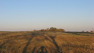
English: Western edge of the Bono Archaeological Site, located on the eastern side of Bono-Tunnelton Road above the East Fork of the White River and one mile north of Bono in Bono Township, Lawrence County, Indiana, United States. Most of the field is a clam shell midden and thus a valuable archaeological site; it is listed on the National Register of Historic Places. |
||
| 日期 | 摄于2011年10月8日 | ||
| 来源 | 自己的作品 | ||
| 作者 | Nyttend | ||
| 授权 (二次使用本文件) |
|
文件历史
点击某个日期/时间查看对应时刻的文件。
| 日期/时间 | 缩略图 | 大小 | 用户 | 备注 | |
|---|---|---|---|---|---|
| 当前 | 2011年10月9日 (日) 12:27 | | 2,816 × 1,584(1.81 MB) | Nyttend(留言 | 贡献) | {{Location|38|44|42|N|86|19|54|W}} {{Information |Description={{en|Western edge of the {{w|Bono Archaeological Site}}, located on the eastern side of Bono-Tunnelton Road above the East Fork of the {{w|White River (Indiana)|White River}} and one mile north |
您不可以覆盖此文件。
文件用途
没有页面使用本文件。
全域文件用途
以下其他wiki使用此文件:
- en.wikipedia.org上的用途
- es.wikipedia.org上的用途
- eu.wikipedia.org上的用途
- ur.wikipedia.org上的用途
- vi.wikipedia.org上的用途
- www.wikidata.org上的用途
- zh.wikipedia.org上的用途