File:Bopha Dec 3 2012 0435Z (alternate).jpg
跳转到导航
跳转到搜索

本预览的尺寸:600 × 600像素。 其他分辨率:240 × 240像素 | 480 × 480像素 | 768 × 768像素 | 1,024 × 1,024像素 | 2,048 × 2,048像素 | 5,000 × 5,000像素。
原始文件 (5,000 × 5,000像素,文件大小:13.9 MB,MIME类型:image/jpeg)
说明
说明
添加一行文字以描述该文件所表现的内容
摘要
[编辑].jpg&action=edit§ion=1)
| 描述 |
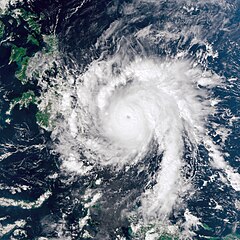
English: Bopha continued moving toward the Philippines on December 3, 2012. The Visible Infrared Imaging Radiometer Suite (VIIRS) on the Suomi NPP satellite acquired this natural-color image the same day. Over the previous day, Bopha moved west of Palau, and by December 3, storm clouds were skirting the island of Mindanao.
The same day that VIIRS acquired this image, the U.S. Navy’s Joint Typhoon Warning Center (JTWC) reported that Bopha packed sustained winds of 140 knots (260 kilometers per hour) and gusts up to 170 knots (315 kilometers per hour). The storm was located about 630 nautical miles (1,170 kilometers) southeast of the Philippine capital of Manila, and was moving toward the west-northwest, JTWC reported. |
|||
| 日期 | ||||
| 来源 | http://earthobservatory.nasa.gov/NaturalHazards/view.php?id=79872 | |||
| 作者 | NASA Earth Observatory image by Jesse Allen, using VIIRS Day-Night Band data from the Suomi National Polar-orbiting Partnership. Caption by Michon Scott. | |||
| 授权 (二次使用本文件) |
|
许可协议
[编辑].jpg&action=edit§ion=2)
| 本文件完全由NASA创作,在美国属于公有领域。根据NASA的版权方针,NASA的材料除非另有声明否则不受版权保护。(参见Template:PD-USGov/zh、NASA版权方针页面或JPL图片使用方针。) | ||
 |
警告:
|
文件历史
点击某个日期/时间查看对应时刻的文件。
| 日期/时间 | 缩略图 | 大小 | 用户 | 备注 | |
|---|---|---|---|---|---|
| 当前 | 2012年12月3日 (一) 22:23 | | 5,000 × 5,000(13.9 MB) | Supportstorm(留言 | 贡献) | {{Information |Description ={{en|1=Bopha continued moving toward the Philippines on December 3, 2012. The Visible Infrared Imaging Radiometer Suite (VIIRS) on the Suomi NPP satellite acquired this natural-color image the same day. Over the previous ... |
您不可以覆盖此文件。
文件用途
以下3个页面使用本文件:
全域文件用途
以下其他wiki使用此文件:
- de.wikipedia.org上的用途
- en.wikipedia.org上的用途
- fr.wikipedia.org上的用途
- id.wikipedia.org上的用途
- pl.wikipedia.org上的用途
- th.wikipedia.org上的用途
- zh.wikipedia.org上的用途
.jpg&oldid=910753187)