File:Borne RN 5.jpg
Jump to navigation
Jump to search

Size of this preview: 433 × 599 pixels. Other resolutions: 173 × 240 pixels | 347 × 480 pixels | 555 × 768 pixels | 740 × 1,024 pixels | 1,480 × 2,048 pixels | 2,819 × 3,901 pixels.
Original file (2,819 × 3,901 pixels, file size: 3.96 MB, MIME type: image/jpeg)
Captions
Captions
Add a one-line explanation of what this file represents
Summary
[edit]
| Description |
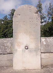
Français : Cette borne kilométrique est un repère visuel et géographique utilisé pour indiquer la distance le long de l'ancienne route nationale 5, une voie de circulation majeure en France. Cette borne est située sur le pont historique de pierres enjambant la rivière Armançon à la limite entre les communes d'Aisy-sur-Armançon, qui se trouve dans le département de l'Yonne, et Rougemont, située dans le département de la Côte d'Or. Elle indique Tonnerre 35 km et Dijon 91 km.
Sa géolocalisation exacte est : 47°40'04.0"N 4°13'57.1"E |
| Date | |
| Source | Own work |
| Author | Pompidoux |
Licensing
[edit]
I, the copyright holder of this work, hereby publish it under the following license:
This file is licensed under the Creative Commons Attribution-Share Alike 4.0 International license.
- You are free:
- to share – to copy, distribute and transmit the work
- to remix – to adapt the work
- Under the following conditions:
- attribution – You must give appropriate credit, provide a link to the license, and indicate if changes were made. You may do so in any reasonable manner, but not in any way that suggests the licensor endorses you or your use.
- share alike – If you remix, transform, or build upon the material, you must distribute your contributions under the same or compatible license as the original.
File history
Click on a date/time to view the file as it appeared at that time.
| Date/Time | Thumbnail | Dimensions | User | Comment | |
|---|---|---|---|---|---|
| current | 18:03, 4 September 2023 | | 2,819 × 3,901 (3.96 MB) | Pompidoux (talk | contribs) | Uploaded own work with UploadWizard |
You cannot overwrite this file.
File usage on Commons
There are no pages that use this file.
File usage on other wikis
The following other wikis use this file:
- Usage on fr.wikipedia.org