File:Bosco Malabotta.Sicily.JPG
From Wikimedia Commons, the free media repository
Jump to navigation
Jump to search
Size of this preview: 800 × 600 pixels. Other resolutions: 320 × 240 pixels | 640 × 480 pixels | 1,024 × 768 pixels | 1,280 × 960 pixels | 2,272 × 1,704 pixels.
Original file (2,272 × 1,704 pixels, file size: 933 KB, MIME type: image/jpeg)
File information
Structured data
Captions
Summary
[edit]DescriptionBosco Malabotta.Sicily.JPG |
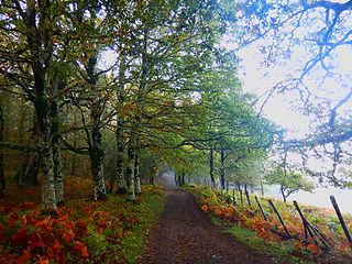
English: the enchanted wood of Malabotta is located in Sicily between the range of Peloritani and Nebrodi
Italiano: Bosco incantato di Malabotta, il sentiero dei patriarchi, Montalbano Elicona, Sicilia |
Source | Own work |
Author | Shifegu |
Licensing
[edit]Public domainPublic domainfalsefalse |
I, the copyright holder of this work, release this work into the public domain. This applies worldwide. In some countries this may not be legally possible; if so: I grant anyone the right to use this work for any purpose, without any conditions, unless such conditions are required by law. |
File history
Click on a date/time to view the file as it appeared at that time.
Date/Time | Thumbnail | Dimensions | User | Comment | |
---|---|---|---|---|---|
current | 15:58, 26 October 2016 | 2,272 × 1,704 (933 KB) | Shifegu (talk | contribs) | {{Information |Description ={{en|1=the enchanted wood of Malabotta is located in Sicily between the range of Peloritani and Nebrodi }} {{it|1=Bosco incantato di Malabotta, il sentiero dei patriarchi, Montalbano Elicona, Sicilia}} |Source ={{... |
You cannot overwrite this file.
File usage on Commons
There are no pages that use this file.
File usage on other wikis
The following other wikis use this file:
- Usage on en.wikipedia.org
- Usage on it.wikipedia.org
Metadata
This file contains additional information such as Exif metadata which may have been added by the digital camera, scanner, or software program used to create or digitize it. If the file has been modified from its original state, some details such as the timestamp may not fully reflect those of the original file. The timestamp is only as accurate as the clock in the camera, and it may be completely wrong.
Camera manufacturer | NIKON |
---|---|
Camera model | COOLPIX AW120 |
Exposure time | 1/40 sec (0.025) |
F-number | f/2.8 |
ISO speed rating | 125 |
Date and time of data generation | 17:13, 15 October 2016 |
Lens focal length | 4.3 mm |
Latitude | 37° 57′ 33.69″ N |
Longitude | 15° 3′ 16.22″ E |
Orientation | Normal |
Horizontal resolution | 300 dpi |
Vertical resolution | 300 dpi |
Software used | COOLPIX AW120V1.0 |
File change date and time | 17:13, 15 October 2016 |
Y and C positioning | Co-sited |
Exposure Program | Normal program |
Exif version | 2.3 |
Date and time of digitizing | 17:13, 15 October 2016 |
Meaning of each component |
|
Image compression mode | 2 |
APEX exposure bias | 0 |
Maximum land aperture | 3 APEX (f/2.83) |
Metering mode | Pattern |
Light source | Unknown |
Flash | Flash did not fire, compulsory flash suppression |
Supported Flashpix version | 1 |
Color space | sRGB |
File source | Digital still camera |
Scene type | A directly photographed image |
Custom image processing | Normal process |
Exposure mode | Auto exposure |
White balance | Auto white balance |
Digital zoom ratio | 0 |
Focal length in 35 mm film | 24 mm |
Scene capture type | Landscape |
Scene control | None |
Contrast | Normal |
Saturation | Normal |
Sharpness | Normal |
Subject distance range | Distant view |
GPS time (atomic clock) | 15:15:41.42 |
Satellites used for measurement | 11 |
Reference for direction of image | True direction |
Direction of image | 59.09 |
Geodetic survey data used | WGS-84 |
GPS date | 15 October 2016 |
GPS tag version | 0.0.3.2 |
Structured data
Items portrayed in this file
depicts
image/jpeg
daba7cff4ef6a814b2e14763545a6d8a69510572
955,659 byte
1,704 pixel
2,272 pixel
Hidden categories: