File:Bosnia and Herzegovina topographic map-sr.svg
Jump to navigation
Jump to search

Size of this PNG preview of this SVG file: 595 × 597 pixels. Other resolutions: 239 × 240 pixels | 478 × 480 pixels | 765 × 768 pixels | 1,021 × 1,024 pixels | 2,041 × 2,048 pixels.
Original file (SVG file, nominally 595 × 597 pixels, file size: 3.85 MB)
Captions
Captions
Add a one-line explanation of what this file represents
Summary
[edit]
| Description |
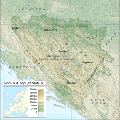
English: Topographic map of Bosnia and Herzegovina |
| Date | (UTC) |
| Source | |
| Author |
|
| This is a retouched picture, which means that it has been digitally altered from its original version. Modifications: translated to Serbian. The original can be viewed here: Bosnia and Herzegovina topographic map-mk.svg:
|
Licensing
[edit]
This file is licensed under the Creative Commons Attribution-Share Alike 3.0 Unported license.
- You are free:
- to share – to copy, distribute and transmit the work
- to remix – to adapt the work
- Under the following conditions:
- attribution – You must give appropriate credit, provide a link to the license, and indicate if changes were made. You may do so in any reasonable manner, but not in any way that suggests the licensor endorses you or your use.
- share alike – If you remix, transform, or build upon the material, you must distribute your contributions under the same or compatible license as the original.
Original upload log
[edit]
This image is a derivative work of the following images:
- File:Bosnia_and_Herzegovina_topographic_map.svg licensed with Cc-by-sa-3.0, GFDL
- 2011-04-21T12:56:09Z DzWiki 595x597 (4151259 Bytes) m
- 2011-04-21T12:49:27Z DzWiki 595x597 (4300673 Bytes) m
- 2011-03-18T15:27:31Z DzWiki 595x597 (3734574 Bytes) m
- 2011-03-11T16:32:11Z DzWiki 588x554 (3657803 Bytes) {{Information |Description ={{en|1=Topographic map of Bosnia and Herzegovina}} |Source ={{own}} |Author =[[User:DzWiki|DzWiki]] |Date = |Permission = |other_versions = }} [[Category:Topograph
- File:Bosnia_and_Herzegovina_topographic_map-mk.svg licensed with Cc-by-sa-3.0, GFDL
- 2011-03-18T16:28:51Z MacedonianBoy 595x597 (4035119 Bytes) с
- 2011-03-18T16:18:24Z MacedonianBoy 595x597 (4031399 Bytes) {{Information |Description ={{en|1=s}} {{mk|1=s}} |Source ={{own}} |Author =[[User:MacedonianBoy|MacedonianBoy]] |Date = |Permission = |other_versions = }}
Uploaded with derivativeFX
File history
Click on a date/time to view the file as it appeared at that time.
| Date/Time | Thumbnail | Dimensions | User | Comment | |
|---|---|---|---|---|---|
| current | 11:52, 28 November 2011 | | 595 × 597 (3.85 MB) | BokicaK (talk | contribs) | == {{int:filedesc}} == {{Information |Description={{en|1=Topographic map of Bosnia and Herzegovina}} |Source=*File:Bosnia_and_Herzegovina_topographic_map.svg *File:Bosnia_and_Herzegovina_topographic_map-mk.svg |Date=2011-11-28 11:47 (UTC) |Aut |
You cannot overwrite this file.
File usage on Commons
The following page uses this file:
File usage on other wikis
The following other wikis use this file:
- Usage on sh.wikipedia.org
- Usage on sr.wikipedia.org