File:Boundary Stone (District of Columbia) NW 1.jpg
Jump to navigation
Jump to search
Size of this preview: 600 × 600 pixels. Other resolutions: 240 × 240 pixels | 480 × 480 pixels | 640 × 640 pixels.
Original file (640 × 640 pixels, file size: 253 KB, MIME type: image/jpeg)
Captions
Captions
Add a one-line explanation of what this file represents
|
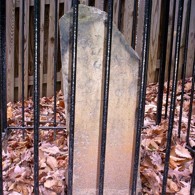
This is an image of a place or building that is listed on the National Register of Historic Places in the United States of America. Its reference number is 91000003. |
Summary
[edit]_NW_1.jpg&action=edit§ion=1)
| Description |
English: DC Boundary Stone Northwest Mile 1,that is the stone 1 mile northwest of the westernmost point in the original District of Columbia. Actually it is now in northern Virginia. The stone was placed in 1791-1792 by Andrew Ellicott and Benjamin Banneker. See zhurnaly.com/maps/DC_Boundary_Stones.html for a map of these stones. |
| Date | |
| Source | https://www.flickr.com/photos/zhurnaly/67703183/sizes/z/in/set-1352644/ |
| Author | zhurnaly (Mark Zimmermann) |
| Object location | | View this and other nearby images on: OpenStreetMap |
|---|
_NW_1.jpg¶ms=038.903056_N_-077.159444_E_globe:Earth_class:object_region:US_type:landmark_scale:1500_&language=en)
Licensing
[edit]_NW_1.jpg&action=edit§ion=2)
| This image, originally posted to Flickr, was reviewed on 6 August 2011 by the administrator or reviewer Warfieldian, who confirmed that it was available on Flickr under the stated license on that date. |
This file is licensed under the Creative Commons Attribution 2.0 Generic license.
- You are free:
- to share – to copy, distribute and transmit the work
- to remix – to adapt the work
- Under the following conditions:
- attribution – You must give appropriate credit, provide a link to the license, and indicate if changes were made. You may do so in any reasonable manner, but not in any way that suggests the licensor endorses you or your use.
File history
Click on a date/time to view the file as it appeared at that time.
| Date/Time | Thumbnail | Dimensions | User | Comment | |
|---|---|---|---|---|---|
| current | 00:32, 5 August 2011 | | 640 × 640 (253 KB) | Smallbones (talk | contribs) |
You cannot overwrite this file.
File usage on Commons
The following 2 pages use this file:
File usage on other wikis
The following other wikis use this file:
_NW_1.jpg&oldid=830723182)