File:Bradgate park general map.png
跳至導覽
跳至搜尋
無更高解析度可提供。
Bradgate_park_general_map.png (653 × 442 像素,檔案大小:350 KB,MIME 類型:image/png)
說明
說明
添加單行說明來描述出檔案所代表的內容
摘要
[編輯]
| 描述 |
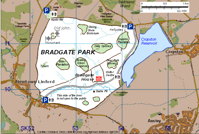
English: Map of Bradgate Park, Leicestershire, England, showing its main topographical features |
| 日期 | |
| 來源 | created by Robin Stevenson based on Ordnance Survey data © Crown copyright and database right 2011 available under OS Opendata, from OS Vectormap District raster map SK51, downloadable from https://www.ordnancesurvey.co.uk/opendatadownload/products.html |
| 作者 | Robin Stevenson based on Ordnance Survey data © Crown copyright and database right 2011 under UK Open Government licence at http://www.nationalarchives.gov.uk/doc/open-government-licence/open-government-licence.htm |
授權條款
[編輯]
This file is licensed by the Ordnance Survey of the United Kingdom under their OS OpenData License
In short: you are free to distribute and modify the file as long as you attribute (including year), the Ordnance Survey. 姓名標示: Contains Ordnance Survey data © Crown copyright and database right (year) Note: Derivative works can be licensed under any Creative Commons Attribution 3.0 Licence. |
_(St_Edwards_Crown).svg)
|
This file is licensed under the United Kingdom Open Government Licence v3.0. |
See also: Meta for information on usage on Wikimedia wikis.
|
檔案歷史
點選日期/時間以檢視該時間的檔案版本。
| 日期/時間 | 縮圖 | 尺寸 | 用戶 | 備註 | |
|---|---|---|---|---|---|
| 目前 | 2011年1月27日 (四) 18:02 | | 653 × 442(350 KB) | RobinLeicester(對話 | 貢獻) | {{Information |Description ={{en|1=Map of Bradgate Park, Leicestershire, England, showing its main topographical features}} |Source =created by Robin Stevenson based on Ordnance Survey data © Crown copyright and database right 2011 available u |
無法覆蓋此檔案。
檔案用途
沒有使用此檔案的頁面。
全域檔案使用狀況
以下其他 wiki 使用了這個檔案:
- ar.wikipedia.org 的使用狀況
- en.wikipedia.org 的使用狀況
- pl.wikipedia.org 的使用狀況
- zh.wikipedia.org 的使用狀況