File:Brcko.png
Jump to navigation
Jump to search

Size of this preview: 800 × 575 pixels. Other resolutions: 320 × 230 pixels | 640 × 460 pixels | 904 × 650 pixels.
Original file (904 × 650 pixels, file size: 53 KB, MIME type: image/png)
Captions
Captions
Add a one-line explanation of what this file represents
Summary
[edit]
| Description |
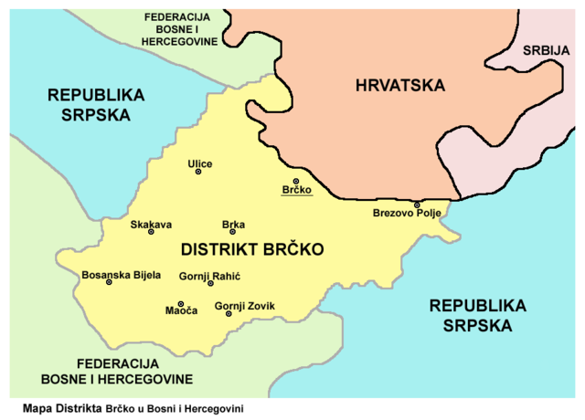
English: Map of Brčko District within Bosnia and Herzegovina. Srpskohrvatski / српскохрватски: Mapa Distrikta Brčko u Bosni i Hercegovini. Čeština: Mapa disriktu Brčko. Zdroj: cs::en:Image:Brcko02.png |
| Date | 7 April 2006 (original upload date) |
| Source | Moved to Commons from cs.wikipedia; description page is/was here. Image was originally created by User:PANONIAN in English Wikipedia (as en:Image:Brcko02.png) and was moved from there to Czech Wikipedia by Zirland. |
| Author | User:PANONIAN (original uploader and author in English Wikipedia), uploader in cs.wikipedia was Zirland. |
| Permission (Reusing this file) |
PD-USER. |
Licensing
[edit]
| |
This work has been released into the public domain by its author, PANONIAN, at the English Wikipedia project. This applies worldwide. In case this is not legally possible: |
References
[edit]
Maps:
- http://www.ohr.int/ohr-offices/brcko/images/mapa%20BD.JPG
- http://www.ohr.int/ohr-offices/brcko/images/map-brcko-district.jpg
- http://2.bp.blogspot.com/_5WVGK4UtqdU/Sg63z3U2T2I/AAAAAAAAAKA/0Gn1b793Isw/s400/Karta+DC+Brčko.gif[dead link]
- http://i21.tinypic.com/35higdf.gif
- http://i40.tinypic.com/25r34f9.jpg
- http://i16.tinypic.com/63w7807.jpg
- http://www.conflictgeographies.org/uploads/2/6/1/8/2618869/388168.jpg?490 archive copy at the Wayback Machine
- United States Department of State
- http://www.thomasgraz.net/glass/map-BIH.gif
- http://vozi.org/images/stories/broj%20registrovanih%20vozila%202010.godina.png
- http://www.conflictgeographies.org/uploads/2/6/1/8/2618869/8958714.jpg?490 archive copy at the Wayback Machine
- http://www.slobodanjovanovic.org/wp-content/uploads/2009/12/bosna-kantoni1.jpg[dead link]
- http://www.visitbosnia.org/bih/images/stories/o_bih/drzavno_uredjenje/entiteti.jpg[dead link]
Largest settlements within the district:
- http://world-gazetteer.com/wg.php?x=1&men=gcis&lng=en&des=gamelan&geo=-27&col=abcdefghinoq&msz=1500&geo=-386[dead link]
Original upload log
[edit]
(All user names refer to cs.wikipedia)
- 2006-04-07 06:33 Zirland 384×275×8 (87099 bytes) Mapa disriktu Brčko Zdroj: [[:en:Image:Brcko02.png]] Autor: [[:en:User:PANONIAN]] {{PD}}
File history
Click on a date/time to view the file as it appeared at that time.
| Date/Time | Thumbnail | Dimensions | User | Comment | |
|---|---|---|---|---|---|
| current | 10:31, 5 December 2013 | | 904 × 650 (53 KB) | WikiEditor2004 (talk | contribs) | aesthetics |
| 14:51, 16 December 2011 |  | 904 × 650 (53 KB) | WikiEditor2004 (talk | contribs) | improved version | |
| 13:15, 11 April 2007 |  | 384 × 275 (85 KB) | File Upload Bot (Martin Kozák) (talk | contribs) | {{Information |Description={{cs|Mapa disriktu Brčko Zdroj: cs::en:Image:Brcko02.png}} |Source=Originally from [http://cs.wikipedia.org cs.wikipedia]; description page is/was [http://cs.wikipedia.org/w/index.php?title=Image%3ABrcko.png here]. |D |
You cannot overwrite this file.
File usage on Commons
The following 2 pages use this file:
File usage on other wikis
The following other wikis use this file:
- Usage on bs.wikipedia.org
- Usage on hr.wikipedia.org
- Usage on sh.wikipedia.org