File:Breakpoints EPAC.gif
Jump to navigation
Jump to search
Size of this preview: 776 × 600 pixels. Other resolutions: 311 × 240 pixels | 621 × 480 pixels | 895 × 692 pixels.
Original file (895 × 692 pixels, file size: 156 KB, MIME type: image/gif)
Captions
Captions
Add a one-line explanation of what this file represents
Summary
[edit]
| Description |
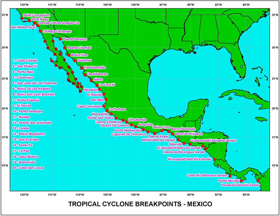
English: A map of the breakpoints used by the [National Hurricane Center] for the issuance of w:tropical cyclone watches and warnings in the Eastern Pacific Ocean. |
| Date | As of December 11, 2006 |
| Source | NHC's Breakpoint Page |
| Author | National Hurricane Center |
| Permission (Reusing this file) |
Work of US Federal Government, public domain. |
Licensing
[edit]
This image is in the public domain because it contains materials that originally came from the U.S. National Oceanic and Atmospheric Administration, taken or made as part of an employee's official duties.
|
File history
Click on a date/time to view the file as it appeared at that time.
| Date/Time | Thumbnail | Dimensions | User | Comment | |
|---|---|---|---|---|---|
| current | 03:46, 11 December 2006 | | 895 × 692 (156 KB) | WindRunner (talk | contribs) | == Summary == {{Information |Description=A map of the [breakpoints|breakpoints (meteorology)] used by the [National Hurricane Center] for the issuance of tropical cyclone watches and warnings in the Eastern Pacific Ocean. |Source=[http://www.nhc.noaa. |
You cannot overwrite this file.
File usage on Commons
There are no pages that use this file.
File usage on other wikis
The following other wikis use this file:
- Usage on en.wikipedia.org