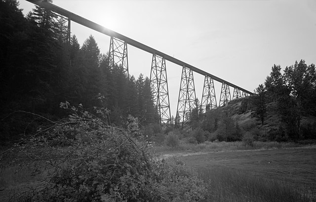
File:Bridge 38, Lawyer Creek, view looking west at Milepost 38.07. It is 1520' long and 280' high - Camas Prairie Railroad HAER ID-41-46 (cut).jpg
Jump to navigation
Jump to search

Size of this preview: 800 × 513 pixels. Other resolutions: 320 × 205 pixels | 640 × 410 pixels | 1,024 × 656 pixels | 1,280 × 820 pixels | 2,560 × 1,641 pixels | 4,823 × 3,091 pixels.
Original file (4,823 × 3,091 pixels, file size: 3.07 MB, MIME type: image/jpeg)
Captions
Captions
Add a one-line explanation of what this file represents
Summary[edit]
.jpg&action=edit§ion=1)
| Description |
English: Bridge 38, Lawyer Creek, view looking west at Milepost 38.07. It is 1520' long and 280' high - Camas Prairie Railroad, Second Subdivision, From Spalding in Nez Perce County, through Lewis County, to Grangeville in Idaho County, Spalding, Nez Perce County, ID |
| Date | |
| Source |
This file was derived from: Bridge 38, Lawyer Creek, view looking west at Milepost 38.07. It is 1520' long and 280' high - Camas Prairie Railroad, Second Subdivision, From Spalding in Nez Perce County, through HAER ID-41-46.tif |
| Author | Rudolph, Glenn |
Licensing[edit]
.jpg&action=edit§ion=2)
| This image or media file contains material based on a work of a National Park Service employee, created as part of that person's official duties. As a work of the U.S. federal government, such work is in the public domain in the United States. See the NPS website and NPS copyright policy for more information. |
File history
Click on a date/time to view the file as it appeared at that time.
| Date/Time | Thumbnail | Dimensions | User | Comment | |
|---|---|---|---|---|---|
| current | 18:02, 18 January 2020 | | 4,823 × 3,091 (3.07 MB) | Krib (talk | contribs) | User created page with UploadWizard |
You cannot overwrite this file.
File usage on Commons
There are no pages that use this file.
File usage on other wikis
The following other wikis use this file:
- Usage on de.wikipedia.org
.jpg&oldid=832981872)