File:Bridge in Snake Spring Township.jpg
Jump to navigation
Jump to search

Size of this preview: 736 × 600 pixels. Other resolutions: 295 × 240 pixels | 589 × 480 pixels | 794 × 647 pixels.
Original file (794 × 647 pixels, file size: 64 KB, MIME type: image/jpeg)
Captions
Captions
Add a one-line explanation of what this file represents
|
This is an image of a place or building that is listed on the National Register of Historic Places in the United States of America. Its reference number is 88000793. |
| Camera location | | View this and other nearby images on: OpenStreetMap |
|---|
| Description |
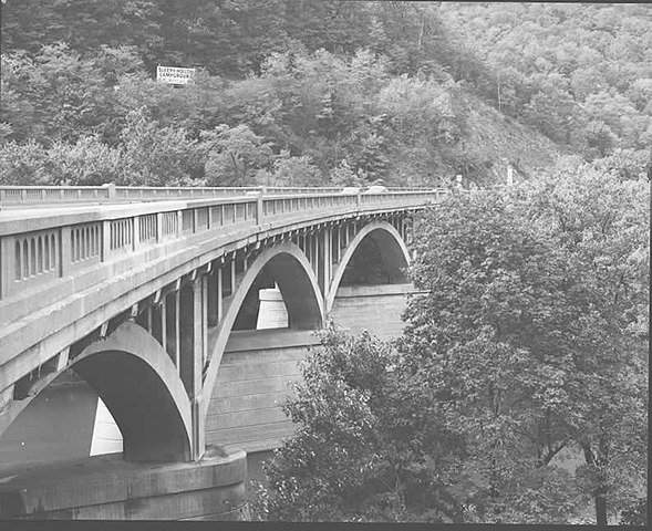
English: Side of the Bridge in Snake Spring Township, which carries Township Road 30 over the Raystown Branch of the Juniata River east of Bedford in Snake Spring Township, Bedford County, Pennsylvania, United States. Built in 1934, the bridge is listed on the National Register of Historic Places. |
|||
| Date | ||||
| Source | "Bridge in Snake Spring Township" (National Register of Historic Places form). National Park Service (June 22, 1988). Photo from http://www.arch.state.pa.us, searchable database, at http://www.arch.state.pa.us/images/hires/H000230_01B.jpg | |||
| Author | PennDOT | |||
| Permission (Reusing this file) |
|

File history
Click on a date/time to view the file as it appeared at that time.
| Date/Time | Thumbnail | Dimensions | User | Comment | |
|---|---|---|---|---|---|
| current | 03:48, 8 December 2009 | | 794 × 647 (64 KB) | Nyttend (talk | contribs) | {{Location|40|0|49|N|78|28|18|W}} {{Information |Description={{en|Side of the {{w|Bridge in Snake Spring Township}}, which carries Township Road 30 over the {{w|Raystown Branch Juniata River|Raystown Branch}} of the {{w|Juniata River}} east of {{w|Bedford |
You cannot overwrite this file.
File usage on Commons
There are no pages that use this file.
File usage on other wikis
The following other wikis use this file:
- Usage on en.wikipedia.org
- Usage on tl.wikipedia.org
- Usage on www.wikidata.org
Metadata
Categories:
- Photographs by Pennsylvania Department of Transportation
- Built in Pennsylvania in 1934
- Bridges in the United States completed in 1934
- 1930s bridges in Pennsylvania
- Bridges in Bedford County, Pennsylvania
- Bridges on the National Register of Historic Places in Pennsylvania
- Concrete deck arch bridges in Pennsylvania
- National Register of Historic Places in Bedford County, Pennsylvania
- Raystown Branch Juniata River
- Open-spandrel arch bridges
- Road bridges in Pennsylvania
- U.S. Route 30 in Pennsylvania
- The Narrows (Pennsylvania)
- 1982 in Pennsylvania