File:Brit IndianEmpireReligions3.jpg
ナビゲーションに移動
検索に移動

このプレビューのサイズ: 741 × 599 ピクセル。 その他の解像度: 297 × 240 ピクセル | 593 × 480 ピクセル | 949 × 768 ピクセル | 1,266 × 1,024 ピクセル | 1,534 × 1,241 ピクセル。
元のファイル (1,534 × 1,241 ピクセル、ファイルサイズ: 2.33メガバイト、MIME タイプ: image/jpeg)
キャプション
キャプション
このファイルの内容を1行で記述してください
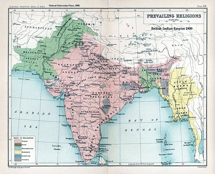
1909 Religious Map of India
概要[編集]
| 解説 |
English: Map "Prevailing Religions of the British Indian Empire, 1909" Key:
|
| 日付 | |
| 原典 | The Imperial Gazetteer of India, Oxford University Press, 1909. Scanned from personal copy and annotated by me (Fowler&fowler«Talk» 04:16, 19 March 2007 (UTC)) |
| 作者 |
English: John George Bartholomew |
| その他のバージョン |
.jpg)


|
このold map画像は、ベクターイメージである SVG ファイルとして再作成されるべきです。これにはいくつかの利点があります。詳しくはCommons:Media for cleanupを参照してください。この画像の SVG 形式がすでに利用可能である場合は、アップロードしてください。アップロード後、この画像にあるこのテンプレートを{{Vector version available|新しい画像ファイル名.svg}}テンプレートで置き換えてください。
|


ライセンス[編集]
|
著作者が1920年に死亡しているため、この著作物は、著作権の保護期間が著作者の死後100年以下である国・地域においてパブリックドメインの状態にあります。 この著作物は1929年1月1日以前に公表され、又はアメリカ合衆国著作権局に登録されたため、アメリカ合衆国においてパブリックドメインの状態にあります。 | |
| このファイルは著作権法の既知の制約(隣接権や関連する権利を含む)から自由であると特定されています。 | |
元のアップロードログ[編集]
元のファイルページはこちら。以下の利用者は全てen.wikipediaに属します。
- 2007-03-19 04:16 Fowler&fowler 1650×1275×8 (338398 bytes) Map "Prevailing Religions of the British Indian Empire, 1909" from the Imperial Gazetteer of India, Oxford University Press, 1909. Scanned from personal copy and annotated by me (~~~~) {{PD-old-75}}
| 注釈 | この画像には注釈がついています: コモンズで注釈を見る |
ファイルの履歴
過去の版のファイルを表示するには、その版の日時をクリックしてください。
| 日付と時刻 | サムネイル | 寸法 | 利用者 | コメント | |
|---|---|---|---|---|---|
| 現在の版 | 2019年1月18日 (金) 02:39 | | 1,534 × 1,241 (2.33メガバイト) | Frank Klemm (トーク | 投稿記録) | Cropped, white balanced |
| 2011年12月29日 (木) 13:27 |  | 1,504 × 1,232 (2.06メガバイト) | Maproom (トーク | 投稿記録) | Made colours less washed-out | |
| 2009年2月11日 (水) 01:20 |  | 1,504 × 1,232 (311キロバイト) | AnonMoos (トーク | 投稿記録) | losslessly cropping margins | |
| 2007年9月21日 (金) 03:06 |  | 1,650 × 1,275 (330キロバイト) | Shooke (トーク | 投稿記録) | {{Information |Description=Map "Prevailing Religions of the British Indian Empire, 1909" from the Imperial Gazetteer of India, Oxford University Press, 1909. Scanned from personal copy and annotated by me ([[:en:User:Fowler&fowler|<font color="#B8860B">F |
このファイルは上書きできません。
ファイルの使用状況
以下の 4 ページがこのファイルを使用しています:
グローバルなファイル使用状況
以下に挙げる他のウィキがこの画像を使っています:
- af.wikipedia.org での使用状況
- ar.wikipedia.org での使用状況
- ast.wikipedia.org での使用状況
- az.wikipedia.org での使用状況
- ba.wikipedia.org での使用状況
- bg.wikipedia.org での使用状況
- bn.wikipedia.org での使用状況
- bn.wikiquote.org での使用状況
- ca.wikipedia.org での使用状況
- ckb.wikipedia.org での使用状況
- cs.wikipedia.org での使用状況
- de.wikipedia.org での使用状況
- diq.wikipedia.org での使用状況
- en.wikipedia.org での使用状況
- History of India
- Kashmir
- Partition of India
- Gazetteer
- History of Hinduism
- Dominion of India
- British Raj
- User:Fowler&fowler
- Talk:History of Pakistan/History of the Pakistan region
- User:Fowler&fowler/Short History Indian Independence Movement
- User:Fowler&fowler/History of Pakistan
- History of the British Raj
- History of East Pakistan
- Talk:Jammu and Kashmir (state)/Archive 1
- User talk:RegentsPark/Archive 4
- User:Fowler&fowler/History of the Pakistan region
- Talk:British Raj/Archive 8
- User:Կիմա34/sandbox
- User:Falcaorib/India and Pakistan
- es.wikipedia.org での使用状況
- eu.wikipedia.org での使用状況
- fa.wikipedia.org での使用状況
- fr.wikipedia.org での使用状況
このファイルのグローバル使用状況を表示する。
カテゴリ:
- The Imperial Gazetteer of India
- Buddhism distribution maps of India
- Christianity distribution maps of India
- Hinduism distribution maps of India
- Islam distribution maps of India
- Jainism distribution maps of India
- Judaism distribution maps of India
- Animism
- 1909 maps of India
- Old maps of Tibet
- Maps of Kham
- 1909 in Tibet
- Old maps of Nepal
- Old maps of Bhutan
- Maps of Lhasa
- Tengri Nor
- Samzhubzê
- Brahmaputra