File:British Decolonisation in Africa.png
跳转到导航
跳转到搜索
本预览的尺寸:600 × 600像素。 其他分辨率:240 × 240像素 | 480 × 480像素 | 768 × 768像素 | 1,024 × 1,024像素 | 2,000 × 2,000像素。
原始文件 (2,000 × 2,000像素,文件大小:406 KB,MIME类型:image/png)
说明
说明
添加一行文字以描述该文件所表现的内容
摘要[编辑]

|
此historical map图片可使用矢量图形重新创建为SVG文件。这具有很多好处;更多信息请参见共享资源:待清理媒体。如果存在此图片的SVG格式,请将其上传,然后将此模板替换为
{{vector version available|新图片名称}}。
建议您将SVG命名为“British Decolonisation in Africa.svg”,这样在使用Vector version available(或Vva)模板时就不需要填写新图片名称参数。 |
| 描述 |
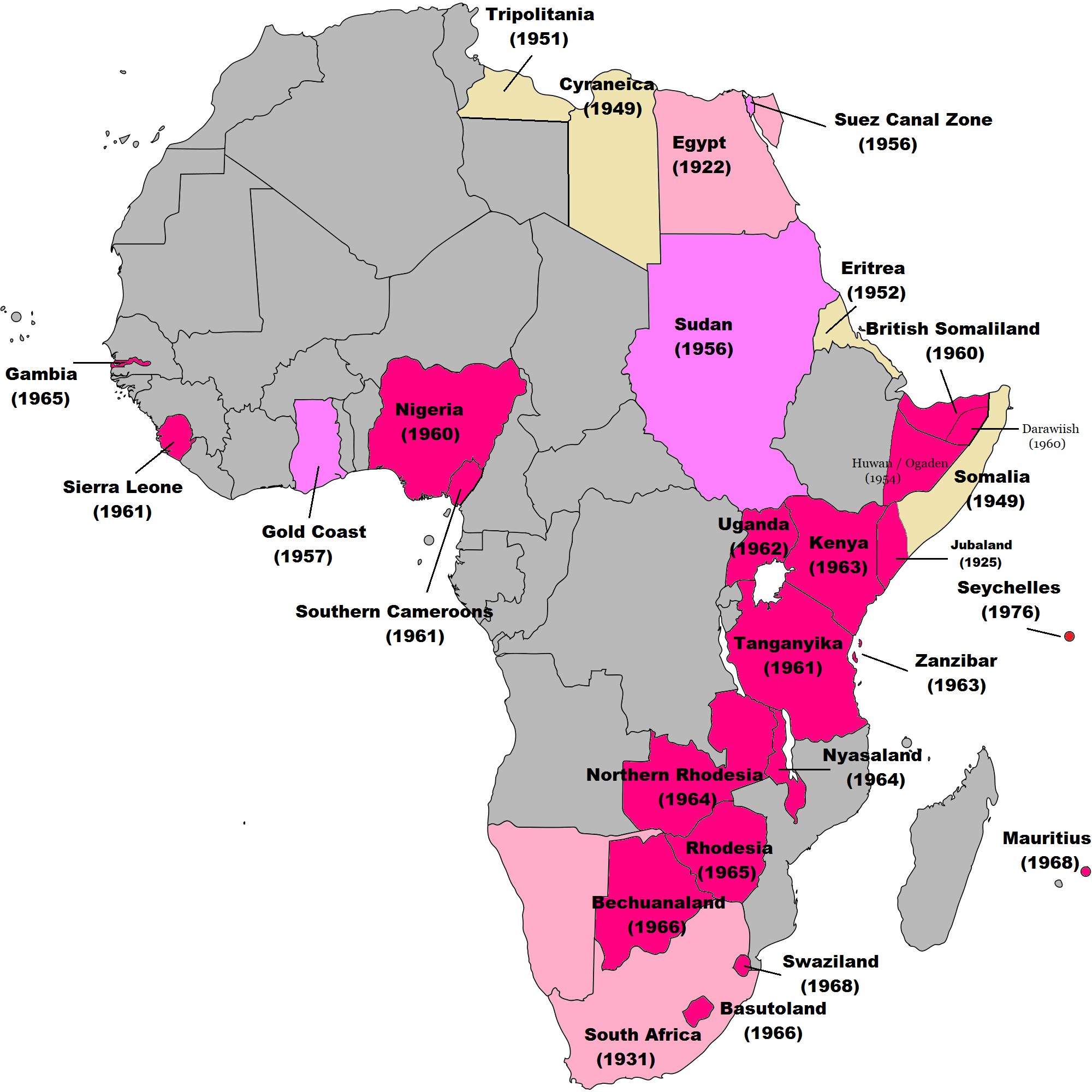
English: Map of British decolonisation in Africa. The beige areas were under British military administration after WW2. The different shades of pink refer to the stages of decolonization according to decades. |
| 日期 | 2008年11月1日 (原始上传日期) |
| 来源 |
Transferred from en.wikipedia; transfer was stated to be made by User:Hejsa. Blank map from File:BlankMap-World3.svg . Original text:
|
| 作者 | The Red Hat of Pat Ferrick t (log) |
| 授权 (二次使用本文件) |
Released into the public domain (by the author). |
许可协议[编辑]
| |
本作品已被作者中文维基百科项目的The Red Hat of Pat Ferrick释出到公有领域。这适用于全世界。 如果这样做不合法的话: |
原始上传日志[编辑]
原始描述頁面位於這裡。下列使用者名稱均來自en.wikipedia。
- 2008-11-02 00:56 The Red Hat of Pat Ferrick 757×785× (171674 bytes) {{Information |Description=Map of British decolonisation in Africa. |Source=I created this work entirely by myself. |Date=1 November 2008 |Author=~~~ |other_versions= }}
文件历史
点击某个日期/时间查看对应时刻的文件。
| 日期/时间 | 缩略图 | 大小 | 用户 | 备注 | |
|---|---|---|---|---|---|
| 当前 | 2021年11月8日 (一) 08:49 | | 2,000 × 2,000(406 KB) | Randomastwritter(留言 | 贡献) | ogaden |
| 2021年10月30日 (六) 03:23 |  | 2,000 × 2,000(399 KB) | Randomastwritter(留言 | 贡献) | juba | |
| 2013年12月7日 (六) 01:38 |  | 2,000 × 2,000(396 KB) | Zello(留言 | 贡献) | corrected map that better reflects historical realities (for example South-West Africa, Rhodesia), also Mauritius and Seychelle added, and new colour for territories under temporary military administration after WW2 | |
| 2013年11月22日 (五) 18:52 |  | 757 × 785(159 KB) | Zello(留言 | 贡献) | Somalia became a UN Trust Territory under Italian administration in 1949. The correction was requested also on the talk page. | |
| 2009年9月13日 (日) 16:08 |  | 757 × 785(168 KB) | Hejsa(留言 | 贡献) | {{Information |Description={{en|Map of British decolonisation in Africa.}} |Source=Transferred from [http://en.wikipedia.org en.wikipedia]; transfer was stated to be made by User:Hejsa. |Date=1 November 2008<br/> ({{Date|2008|11|02}} (original upload |
您不可以覆盖此文件。
文件用途
没有页面使用本文件。
全域文件用途
以下其他wiki使用此文件:
- ar.wikipedia.org上的用途
- ast.wikipedia.org上的用途
- azb.wikipedia.org上的用途
- az.wikipedia.org上的用途
- ba.wikipedia.org上的用途
- cs.wikipedia.org上的用途
- da.wikipedia.org上的用途
- de.wikipedia.org上的用途
- el.wikipedia.org上的用途
- en.wikipedia.org上的用途
- eu.wikipedia.org上的用途
- fr.wikipedia.org上的用途
- fr.wikiversity.org上的用途
- hy.wikipedia.org上的用途
- id.wikipedia.org上的用途
- it.wikipedia.org上的用途
- ka.wikipedia.org上的用途
- ko.wikipedia.org上的用途
- lv.wikipedia.org上的用途
- ms.wikipedia.org上的用途
- nl.wikipedia.org上的用途
- no.wikipedia.org上的用途
- pl.wikipedia.org上的用途
- pt.wikipedia.org上的用途
- ru.wikipedia.org上的用途
- si.wikipedia.org上的用途
- th.wikipedia.org上的用途
查看本文件的更多全域用途。