File:British National Grid Letters and Numbers.png
Jump to navigation
Jump to search

Size of this preview: 325 × 598 pixels. Other resolutions: 130 × 240 pixels | 260 × 480 pixels | 912 × 1,679 pixels.
Original file (912 × 1,679 pixels, file size: 389 KB, MIME type: image/png)
Captions
Captions
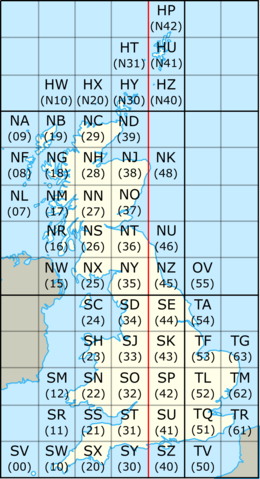
National Grid 100 km squares with both letters and numbers
Summary
[edit]
| Description |
English: The British Ordnance Survey national grid reference system with 100 km squares labelled both with number and letters. |
| Date | (UTC) |
| Source |
This file was derived from: British National Grid.svg:  |
| Author |
|
| This is a retouched picture, which means that it has been digitally altered from its original version. Modifications: Added numbers for 100km grid squares. The original can be viewed here: British National Grid.svg:
|
Licensing
[edit]
I, the copyright holder of this work, hereby publish it under the following license:
This file is licensed under the Creative Commons Attribution-Share Alike 3.0 Unported license.
- You are free:
- to share – to copy, distribute and transmit the work
- to remix – to adapt the work
- Under the following conditions:
- attribution – You must give appropriate credit, provide a link to the license, and indicate if changes were made. You may do so in any reasonable manner, but not in any way that suggests the licensor endorses you or your use.
- share alike – If you remix, transform, or build upon the material, you must distribute your contributions under the same or compatible license as the original.
Original upload log
[edit]
This image is a derivative work of the following images:
- File:British National Grid.svg licensed with Cc-by-sa-3.0
- 2010-07-08T20:06:31Z Nandhp 204x377 (80100 Bytes) Remove temporary data (reference to original raster image)
- 2010-07-08T20:05:06Z Nandhp 204x377 (84879 Bytes) {{Information |Description={{en|The [[:en:British national grid reference system]]}} |Source=*[[:File:National_Grid_for_Great_Britain_with_central_meridian.gif|]] *[[:File:United_Kingdom_and_North-West_France.svg|]] |Date=201
Uploaded with derivativeFX
File history
Click on a date/time to view the file as it appeared at that time.
| Date/Time | Thumbnail | Dimensions | User | Comment | |
|---|---|---|---|---|---|
| current | 11:36, 10 March 2019 | | 912 × 1,679 (389 KB) | Kognos (talk | contribs) | == {{int:filedesc}} == {{Information |Description={{en|The en:British national grid reference system}} |Source={{Derived from|British National Grid.svg|display=50}} |Date=2019-03-10 11:32 (UTC) |Author=* File:British National Grid.svg: *National_Grid_for_Great_Britain_with_central_meridian.gif: *[[:File:National_Grid_for_Great_Britain_with_central_meridian.png|National_Grid_for_Great_B... |
You cannot overwrite this file.
File usage on Commons
The following page uses this file: