File:British isles 802.jpg
跳至導覽
跳至搜尋
預覽大小:572 × 599 像素。 其他解析度:229 × 240 像素 | 458 × 480 像素 | 733 × 768 像素 | 1,076 × 1,127 像素。
原始檔案 (1,076 × 1,127 像素,檔案大小:1.29 MB,MIME 類型:image/jpeg)
說明
說明
添加單行說明來描述出檔案所代表的內容
摘要
[編輯]
| 描述 |
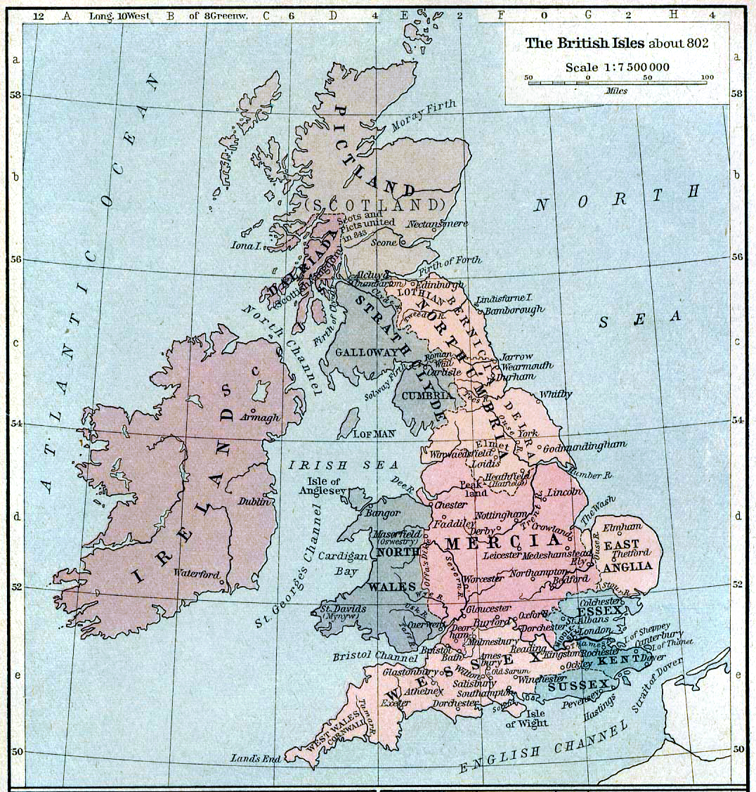
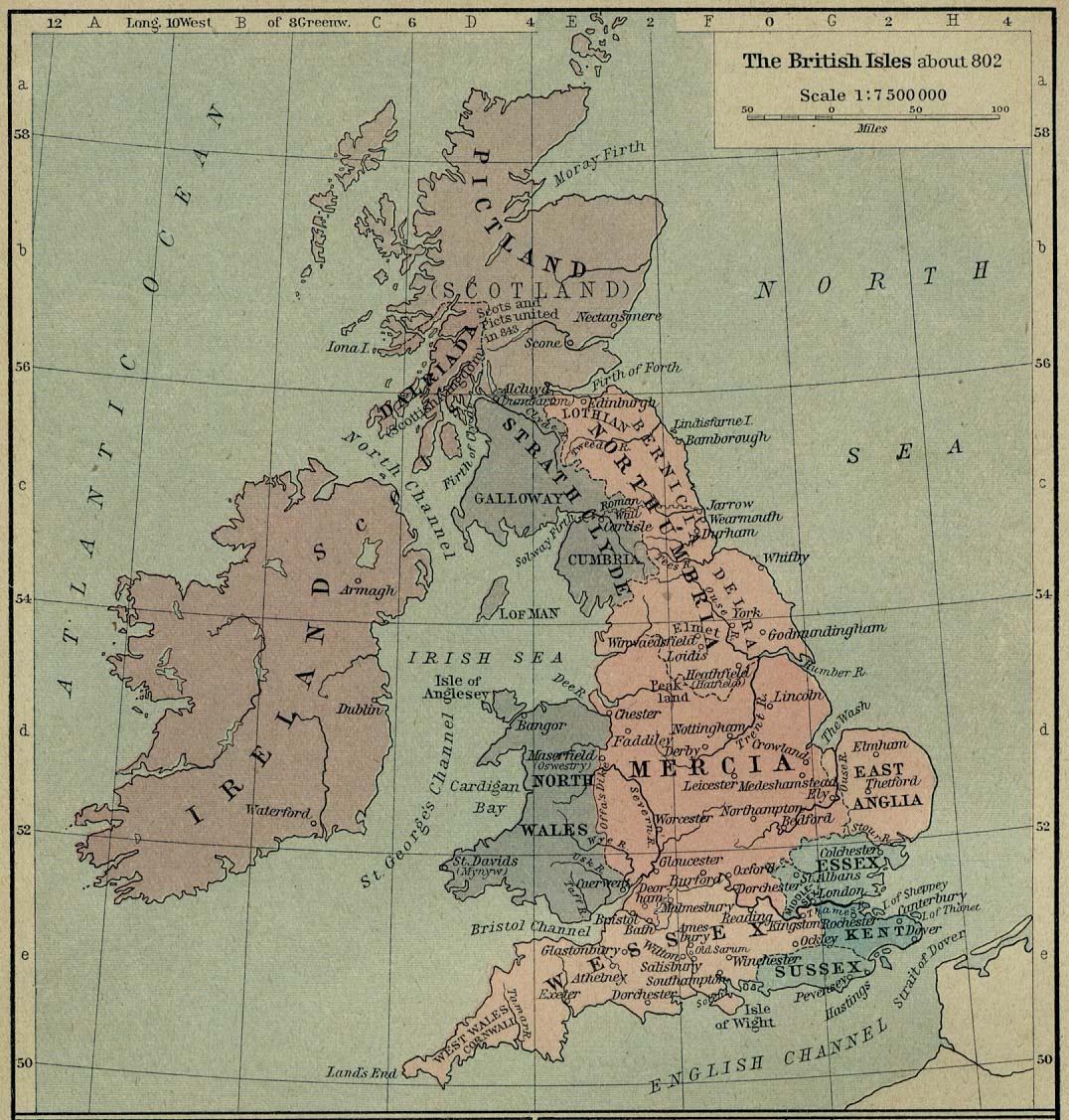
English: Map of the British Isles claiming to represent borders circa 802 AD. |
| 日期 | |
| 來源 | Shepherd, William R. (1926年) 《 Historical Atlas》、Category:New York: Henry Holt and Company |
| 作者 |
授權條款
[編輯]
|
本作品作者於1934年逝世,在其來源國以及其他版權期限是作者逝世後80年或以下的國家與地區屬於公有領域。 | |
| 此作品無已知的著作權限制,亦不受所有相關和鄰接的權利限制。 | |
檔案歷史
點選日期/時間以檢視該時間的檔案版本。
| 日期/時間 | 縮圖 | 尺寸 | 用戶 | 備註 | |
|---|---|---|---|---|---|
| 目前 | 2019年8月12日 (一) 21:30 | | 1,076 × 1,127(1.29 MB) | Alphathon(對話 | 貢獻) | A few more minor tweaks |
| 2019年8月12日 (一) 21:24 |  | 1,076 × 1,127(1.24 MB) | Alphathon(對話 | 貢獻) | re-did cleaning (using original version) | |
| 2006年10月8日 (日) 18:36 |  | 1,076 × 1,127(1.19 MB) | Steinsky(對話 | 貢獻) | cleaned | |
| 2005年12月3日 (六) 15:47 |  | 1,076 × 1,127(273 KB) | Migdejong(對話 | 貢獻) | Map of the isle Great Brittain in the year 802. Image comes from the University of Texas at Austin: http://geography.about.com/gi/dynamic/offsite.htm?site=http://www.lib.utexas.edu/maps/historical/history%5Feurope.html Map is released into the publi |
無法覆蓋此檔案。
檔案用途
全域檔案使用狀況
以下其他 wiki 使用了這個檔案:
- be-tarask.wikipedia.org 的使用狀況
- be.wikipedia.org 的使用狀況
- br.wikipedia.org 的使用狀況
- de.wikipedia.org 的使用狀況
- el.wikipedia.org 的使用狀況
- en.wikipedia.org 的使用狀況
- List of monarchs of East Anglia
- Talk:East Anglia
- List of monarchs of Wessex
- List of monarchs of Northumbria
- List of monarchs of Mercia
- List of monarchs of Kent
- List of monarchs of Sussex
- History of Cornwall
- Constitutional status of Cornwall
- Talk:Regions of England
- Wikipedia:WikiProject Anglo-Saxon Kingdoms
- User:Amitchell125/listofmonarchsofeastanglia
- Template:Anglo-Saxon kings
- fa.wikipedia.org 的使用狀況
- fr.wikipedia.org 的使用狀況
- gd.wikipedia.org 的使用狀況
- got.wikipedia.org 的使用狀況
- he.wikipedia.org 的使用狀況
- hu.wikipedia.org 的使用狀況
- it.wikipedia.org 的使用狀況
檢視此檔案的更多全域使用狀況。