File:British map of Canton, 1840.jpg
Original file (525 × 800 pixels, file size: 153 KB, MIME type: image/jpeg)
Captions
Captions
Summary
[edit]| Description |
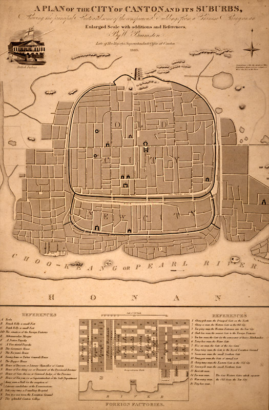
English: A plan of the city of Canton and its suburbs. REFERENCES A Rocks B French Folly a small Fort C Dutch Folly a small Fort DD The situation of the Foreign Factories E Mehammedan Mosque F A Native Pagoda G A Five-storied Pagoda H The Governor's House I The Foo-yuen's House]] K Tseang-keun or Tartar General's House L The Hoppo's House M House of Heo-yuen or Literary Chancellor of Canton N House of Poo-ching sze or Treasurer of the Provincial Revenue O House of Gan-cha sze or Criminal Judge of the Province P House of Yen yun sze or Superintendant of the Salt Department Q Kung yuen a Hall for the reception of Literary candidates at the Examinations R Yuh-ying-tang, a Foundling Hospital S Teen-tsze ma taou, the Execution Ground T The splendid Canton College |
| Date | |
| Source | http://ocw.mit.edu/ans7870/21f/21f.027/rise_fall_canton_03/canton.html |
| Author | W. Bramston |
| Other versions |
|


Licensing
[edit]
|
This work is in the public domain in its country of origin and other countries and areas where the copyright term is the author's life plus 70 years or fewer.
| |
| This file has been identified as being free of known restrictions under copyright law, including all related and neighboring rights. | |
File history
Click on a date/time to view the file as it appeared at that time.
| Date/Time | Thumbnail | Dimensions | User | Comment | |
|---|---|---|---|---|---|
| current | 07:11, 2 May 2010 | | 525 × 800 (153 KB) | Spellcast (talk | contribs) | == {{int:filedesc}} == {{Information |Description={{en|A plan of the city of Canton and its suburbs.}} |Date=1840 |Source=http://ocw.mit.edu/ans7870/21f/21f.027/rise_fall_canton_03/canton.html |Author=W. Bramston |Permission= |other_versions= }} == {{int |
You cannot overwrite this file.
File usage on Commons
The following 2 pages use this file:
File usage on other wikis
The following other wikis use this file:
- Usage on en.wikipedia.org
- Usage on zh-yue.wikipedia.org