File:Bruecke am Alten-Kanal.jpg
Original file (3,000 × 1,993 pixels, file size: 1.22 MB, MIME type: image/jpeg)
Captions
Summary[edit]
DescriptionBruecke am Alten-Kanal.jpg |
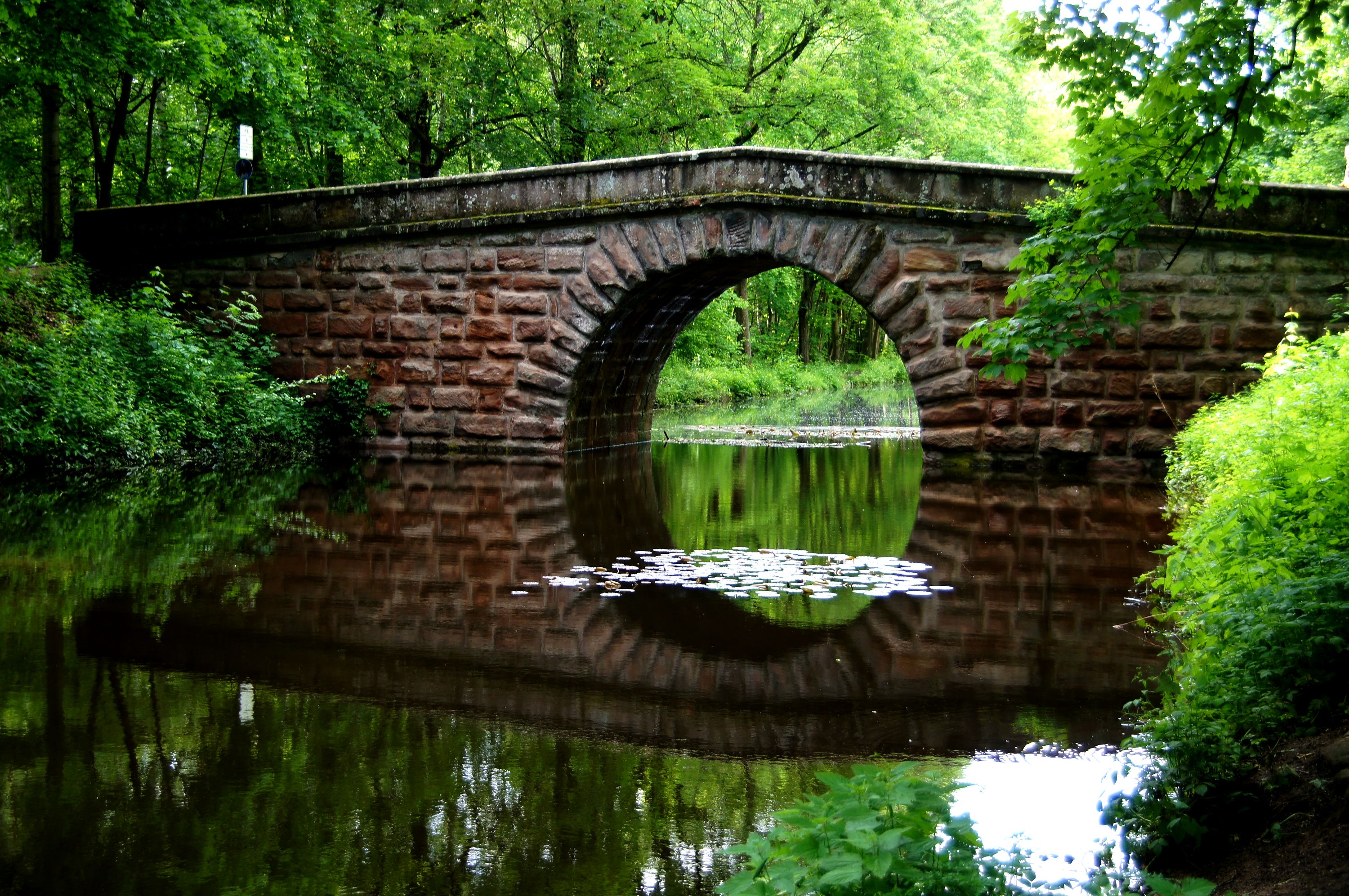
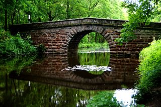
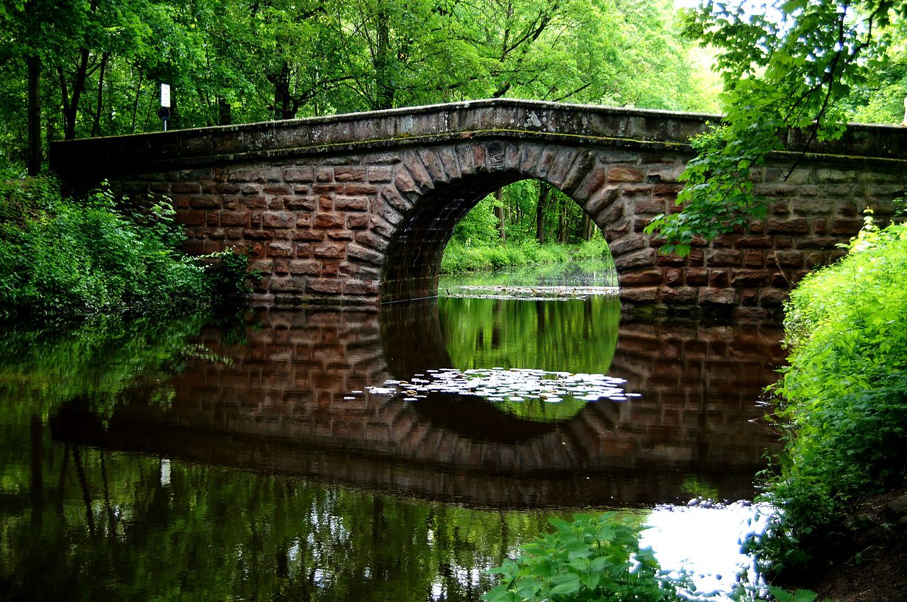
Deutsch: Brücke über den Alten Kanal im Süden von Nuernberg English: Bridge over the Old Channel in the south of Nuremberg This is a photograph of an architectural monument. It is on the list of cultural monuments of Bayern, no. 0. |
Date | |
Source | Own work |
Author | Joachim50 |
Camera location | 49° 21′ 51.94″ N, 11° 04′ 23.73″ E | View this and other nearby images on: OpenStreetMap | 49.364428; 11.073257 |
---|
Licensing[edit]
- You are free:
- to share – to copy, distribute and transmit the work
- to remix – to adapt the work
- Under the following conditions:
- attribution – You must give appropriate credit, provide a link to the license, and indicate if changes were made. You may do so in any reasonable manner, but not in any way that suggests the licensor endorses you or your use.
- share alike – If you remix, transform, or build upon the material, you must distribute your contributions under the same or compatible license as the original.
This image was uploaded as part of Wiki Loves Monuments 2013.
Afrikaans ∙ Alemannisch ∙ azərbaycanca ∙ Bahasa Indonesia ∙ Bahasa Melayu ∙ Bikol Central ∙ bosanski ∙ brezhoneg ∙ català ∙ čeština ∙ Cymraeg ∙ dansk ∙ davvisámegiella ∙ Deutsch ∙ eesti ∙ English ∙ español ∙ Esperanto ∙ euskara ∙ français ∙ Frysk ∙ Gaeilge ∙ galego ∙ hrvatski ∙ Ido ∙ italiano ∙ latviešu ∙ Lëtzebuergesch ∙ Malagasy ∙ magyar ∙ Malti ∙ Nederlands ∙ norsk ∙ norsk nynorsk ∙ norsk bokmål ∙ polski ∙ português ∙ português do Brasil ∙ română ∙ shqip ∙ sicilianu ∙ slovenčina ∙ slovenščina ∙ suomi ∙ svenska ∙ Tagalog ∙ Türkçe ∙ Yorùbá ∙ Zazaki ∙ Ελληνικά ∙ беларуская ∙ беларуская (тарашкевіца) ∙ български ∙ кыргызча ∙ македонски ∙ русский ∙ српски / srpski ∙ українська ∙ ქართული ∙ հայերեն ∙ नेपाली ∙ हिन्दी ∙ বাংলা ∙ മലയാളം ∙ ไทย ∙ 한국어 ∙ +/− |
File history
Click on a date/time to view the file as it appeared at that time.
Date/Time | Thumbnail | Dimensions | User | Comment | |
---|---|---|---|---|---|
current | 13:40, 17 September 2013 | 3,000 × 1,993 (1.22 MB) | Joachim50 (talk | contribs) | User created page with UploadWizard |
You cannot overwrite this file.
File usage on Commons
The following 2 pages use this file:
File usage on other wikis
The following other wikis use this file:
Metadata
This file contains additional information such as Exif metadata which may have been added by the digital camera, scanner, or software program used to create or digitize it. If the file has been modified from its original state, some details such as the timestamp may not fully reflect those of the original file. The timestamp is only as accurate as the clock in the camera, and it may be completely wrong.
Image title | SONY DSC |
---|---|
Camera manufacturer | SONY |
Camera model | SLT-A55V |
Exposure time | 1/60 sec (0.016666666666667) |
F-number | f/4.5 |
ISO speed rating | 160 |
Date and time of data generation | 16:50, 4 June 2013 |
Lens focal length | 35 mm |
Latitude | 49° 21′ 51.94″ N |
Longitude | 11° 4′ 23.72″ E |
Altitude | 102 meters above sea level |
Orientation | Normal |
Horizontal resolution | 72 dpi |
Vertical resolution | 72 dpi |
Software used | SLT-A55V v2.00 |
File change date and time | 16:50, 4 June 2013 |
Y and C positioning | Co-sited |
Exposure Program | Landscape mode (for landscape photos with the background in focus) |
Exif version | 2.3 |
Date and time of digitizing | 16:50, 4 June 2013 |
Meaning of each component |
|
Image compression mode | 3 |
APEX brightness | 4.75 |
APEX exposure bias | 0 |
Maximum land aperture | 4.34 APEX (f/4.5) |
Metering mode | Pattern |
Light source | Unknown |
Flash | Flash did not fire, compulsory flash suppression |
Supported Flashpix version | 1 |
Color space | sRGB |
File source | Digital still camera |
Scene type | A directly photographed image |
Custom image processing | Normal process |
Exposure mode | Auto exposure |
White balance | Auto white balance |
Focal length in 35 mm film | 52 mm |
Scene capture type | Landscape |
Contrast | Normal |
Saturation | Normal |
Sharpness | Normal |
GPS time (atomic clock) | 15:18 |
Receiver status | Measurement interoperability |
Measurement mode | 3-dimensional measurement |
Speed unit | Kilometers per hour |
Speed of GPS receiver | 0.6 |
Reference for direction of movement | True direction |
Direction of movement | 243.05 |
Geodetic survey data used | WGS-84 |
GPS date | 19 October 2012 |
GPS differential correction | 0 |
GPS tag version | 0.0.3.2 |
Structured data
Items portrayed in this file
depicts
49°21'51.94102"N, 11°4'23.72401"E
4 June 2013
0.01666666666666666666 second
4.5
35 millimetre
160
image/jpeg
71922483cfe734b1ad103d1e6fc6b4b93854fb1e
1,282,467 byte
1,993 pixel
3,000 pixel
- Files with coordinates missing SDC location of creation (49° N, 11°E)
- CC-BY-SA-3.0
- Self-published work
- Images from Wiki Loves Monuments 2013
- Images from Wiki Loves Monuments 2013 in Germany
- Images from Wiki Loves Monuments missing SDC location of creation
- Images from Wiki Loves Monuments 2013, DE-BY
- Uploaded via Campaign:wlm-de-by
- Winners of Wiki Loves Monuments 2013 in Germany
- Pages with maps