File:Budapest ghetto water tap plaque (Budapest-07 Rumbach Sebestyén u 10).jpg
Jump to navigation
Jump to search
Size of this preview: 679 × 600 pixels. Other resolutions: 272 × 240 pixels | 543 × 480 pixels | 869 × 768 pixels | 1,159 × 1,024 pixels | 1,723 × 1,522 pixels.
Original file (1,723 × 1,522 pixels, file size: 1,014 KB, MIME type: image/jpeg)
Captions
Captions
Add a one-line explanation of what this file represents
Summary
[edit].jpg&action=edit§ion=1)
| Description |
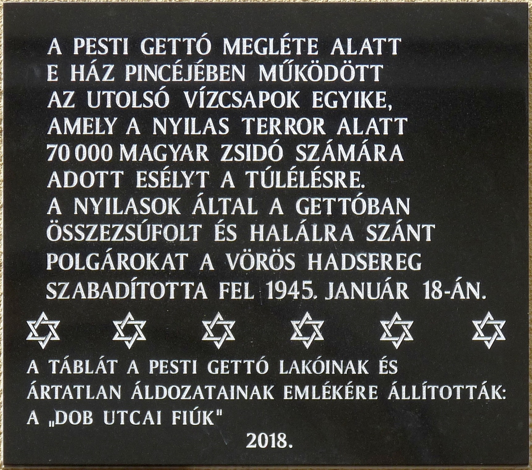
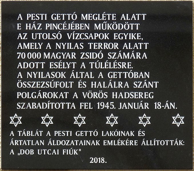
English: Plaque commemorating the Budapest ghetto's living conditions in 1945. The basement of the marked house held one of the last few functioning water taps in the Budapest Ghetto, which made it possible for seventy thousand Hungarian Jews to survive during the time of the Nazi terror. Crowded into the Ghetto by the fascist Arrow Cross militia arid destined to die, citizens were finally liberated by soldiers of the Red Army on 18 January 1945. This plaque was placed by survivors and their children on April 16, 2018, on the Holocaust Memorial Day in Hungary. (Budapest, District VII, Rumbach Sebestyén Street Nr 10)
Français : Plaque commémorant les conditions de vie du ghetto de Budapest en 1945. Dans le sous-sol de la maison marquaée fonctionnait l'un des derniers robinets du ghetto de Budapest, permettant à soixante-dix mille juifs hongrois de survivre à l'époque de la terreur nazie. Encombrés dans le ghetto par la milice fasciste Arrow Cross et destinés à mourir, les citoyens ont été finalement libérés par des soldats de l'Armée rouge le 18 janvier 1945. Cette plaque a été placée par des survivants et leurs enfants le 16 avril 2018 à l'occasion du Jour commémoratif de l'Holocauste en Hongrie. (10 rue Rumbach Sebestyén, Budapest 7e arr.)
Magyar: A budapesti gettó életkörülményeire emlékeztető tábla. A jelzett ház pincéjében működött a budapesti gettó utolsó vízcsapjainak egyike, amely hetvenezer magyar zsidó számára adott esélyt a túlélésre, a gettó 1945. január 18-án történt felszabadításáig. Az emléktáblát a túlélők és gyermeik állították 2018. április 16-án a holokauszt magyarországi áldozatainak emléknapján. (Budapest VII. kerület, Rumbach Sebestyén utca 10.) |
| Date | Taken on 10 May 2018, 09:42:01 |
| Source | Own work |
| Author | Fekist |
| Camera location | | View this and other nearby images on: OpenStreetMap |
|---|
.jpg¶ms=047.497461_N_0019.058841_E_globe:Earth_type:camera__&language=en)
Licensing
[edit].jpg&action=edit§ion=2)
I, the copyright holder of this work, hereby publish it under the following license:
This file is licensed under the Creative Commons Attribution-Share Alike 4.0 International license.
- You are free:
- to share – to copy, distribute and transmit the work
- to remix – to adapt the work
- Under the following conditions:
- attribution – You must give appropriate credit, provide a link to the license, and indicate if changes were made. You may do so in any reasonable manner, but not in any way that suggests the licensor endorses you or your use.
- share alike – If you remix, transform, or build upon the material, you must distribute your contributions under the same or compatible license as the original.
File history
Click on a date/time to view the file as it appeared at that time.
| Date/Time | Thumbnail | Dimensions | User | Comment | |
|---|---|---|---|---|---|
| current | 11:45, 10 May 2018 | | 1,723 × 1,522 (1,014 KB) | Fekist (talk | contribs) | User created page with UploadWizard |
You cannot overwrite this file.
File usage on Commons
The following 2 pages use this file:
File usage on other wikis
The following other wikis use this file:
- Usage on fr.wikipedia.org
- Usage on hu.wikipedia.org
.jpg&oldid=836558842)