File:Building zone map, city and county of Denver - as adopted by the city council, February 1925 - DPLA - 20d213966336f1469add0025e667ce01.jpg
Jump to navigation
Jump to search

Size of this preview: 608 × 600 pixels. Other resolutions: 243 × 240 pixels | 487 × 480 pixels | 779 × 768 pixels | 1,038 × 1,024 pixels | 2,077 × 2,048 pixels | 10,011 × 9,873 pixels.
Original file (10,011 × 9,873 pixels, file size: 19.28 MB, MIME type: image/jpeg)
Captions
Captions
Add a one-line explanation of what this file represents
| Warning | The original file is very high-resolution. It might not load properly or could cause your browser to freeze when opened at full size. |
|---|
Summary
[edit]This file was uploaded by the Digital Public Library of America, and the following item metadata was created by the contributing institution's staff.
Note: this data is being maintained by an automated bot, synced with the source data.
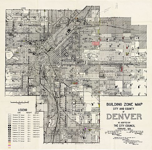
| Description | Shows residential, commercial, and business districts. 1925 map, revised to April 1, 1944. | ||||||||||||||||||||
| Title | Building zone map, city and county of Denver : as adopted by the city council, February 1925 | ||||||||||||||||||||
| Institution |
|
||||||||||||||||||||
| Subject | |||||||||||||||||||||
| Source |
Plains to Peaks Collective |
||||||||||||||||||||
| Author |
Denver (Colo.). City Council |
||||||||||||||||||||
| Permission (Reusing this file) |
Copyright determination made by Denver Public Library (Q69470198) using RightsStatements.org
|
||||||||||||||||||||
| Partnership |
|
||||||||||||||||||||


File history
Click on a date/time to view the file as it appeared at that time.
| Date/Time | Thumbnail | Dimensions | User | Comment | |
|---|---|---|---|---|---|
| current | 07:07, 23 March 2022 | | 10,011 × 9,873 (19.28 MB) | DPLA bot (talk | contribs) | Uploading DPLA ID 20d213966336f1469add0025e667ce01 |
| 20:26, 17 March 2022 |  | 10,011 × 9,873 (19.27 MB) | DPLA bot (talk | contribs) | Uploading DPLA ID 20d213966336f1469add0025e667ce01 | |
| 12:57, 18 December 2020 |  | 8,999 × 8,875 (14.71 MB) | DPLA bot (talk | contribs) | Uploading DPLA ID 20d213966336f1469add0025e667ce01 |
You cannot overwrite this file.
File usage on Commons
There are no pages that use this file.