File:Burgruine Stallegg 07 2015-08.jpg
Original file (4,800 × 3,200 pixels, file size: 7.07 MB, MIME type: image/jpeg)
Captions
Summary[edit]
DescriptionBurgruine Stallegg 07 2015-08.jpg |
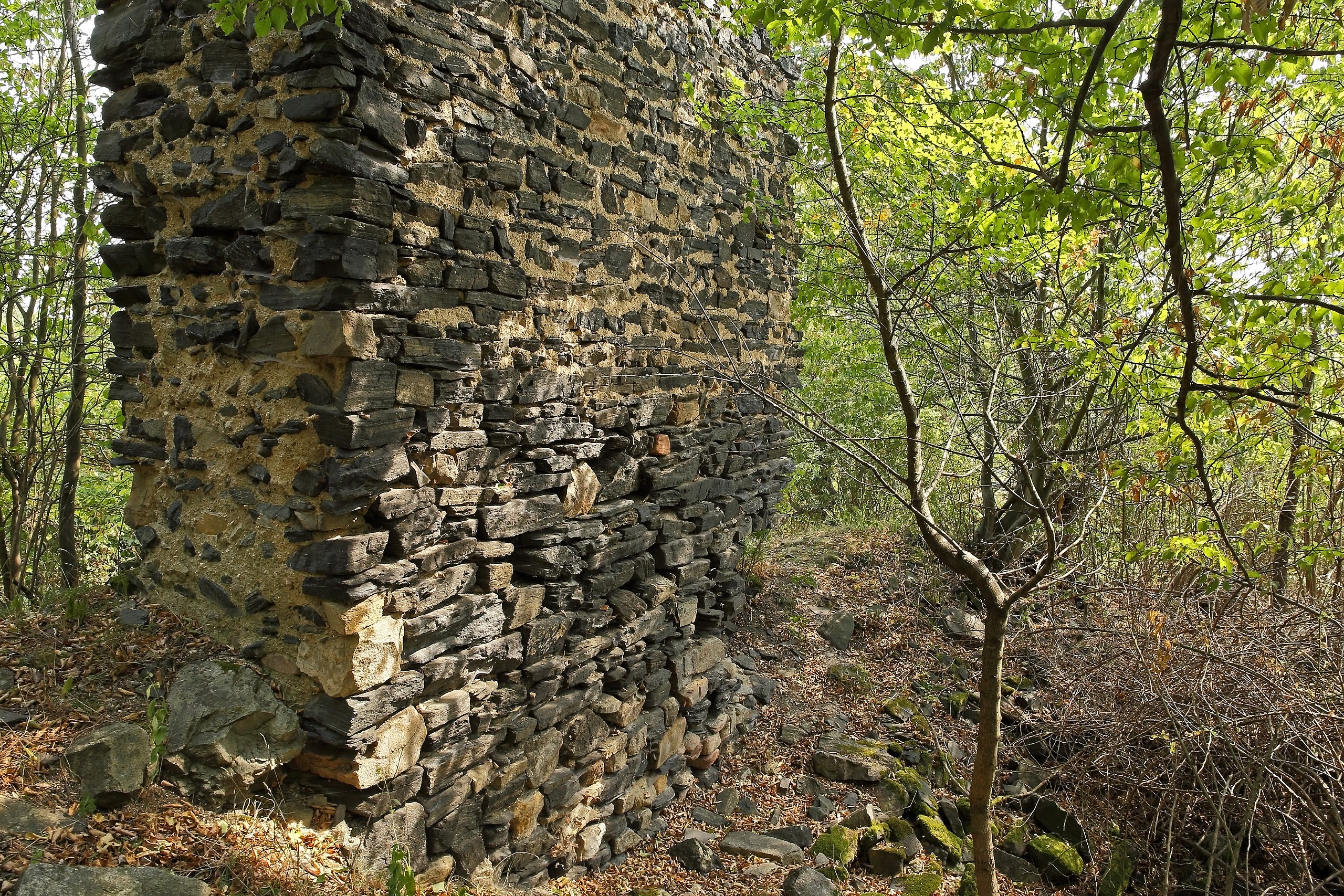
Deutsch: Die Burg Stallegg wurde Ende des 12. Jahrhunderts erbaut und 1212 erstmals urkundlich erwähnt. Ende des 15. Jahrhunderts wurde sie aufgegeben und verfiel. Um 1600 wurde sie bereits als Ruine bezeichnet. |
Date | |
Source | Own work |
Author | Duke of W4 |
Camera location | 48° 36′ 43.9″ N, 15° 38′ 31.94″ E | View this and other nearby images on: OpenStreetMap | 48.612194; 15.642206 |
---|
Licensing[edit]
- You are free:
- to share – to copy, distribute and transmit the work
- to remix – to adapt the work
- Under the following conditions:
- attribution – You must give appropriate credit, provide a link to the license, and indicate if changes were made. You may do so in any reasonable manner, but not in any way that suggests the licensor endorses you or your use.
- share alike – If you remix, transform, or build upon the material, you must distribute your contributions under the same or compatible license as the original.
This image was uploaded as part of Wiki Loves Monuments 2015.
Afrikaans ∙ Alemannisch ∙ azərbaycanca ∙ Bahasa Indonesia ∙ Bahasa Melayu ∙ Bikol Central ∙ bosanski ∙ brezhoneg ∙ català ∙ čeština ∙ Cymraeg ∙ dansk ∙ davvisámegiella ∙ Deutsch ∙ eesti ∙ English ∙ español ∙ Esperanto ∙ euskara ∙ français ∙ Frysk ∙ Gaeilge ∙ galego ∙ hrvatski ∙ Ido ∙ italiano ∙ latviešu ∙ Lëtzebuergesch ∙ Malagasy ∙ magyar ∙ Malti ∙ Nederlands ∙ norsk ∙ norsk nynorsk ∙ norsk bokmål ∙ polski ∙ português ∙ português do Brasil ∙ română ∙ shqip ∙ sicilianu ∙ slovenčina ∙ slovenščina ∙ suomi ∙ svenska ∙ Tagalog ∙ Türkçe ∙ Yorùbá ∙ Zazaki ∙ Ελληνικά ∙ беларуская ∙ беларуская (тарашкевіца) ∙ български ∙ кыргызча ∙ македонски ∙ русский ∙ српски / srpski ∙ українська ∙ ქართული ∙ հայերեն ∙ नेपाली ∙ हिन्दी ∙ বাংলা ∙ മലയാളം ∙ ไทย ∙ 한국어 ∙ +/− |
File history
Click on a date/time to view the file as it appeared at that time.
Date/Time | Thumbnail | Dimensions | User | Comment | |
---|---|---|---|---|---|
current | 06:11, 1 September 2015 | 4,800 × 3,200 (7.07 MB) | Duke of W4 (talk | contribs) | User created page with UploadWizard |
You cannot overwrite this file.
File usage on Commons
There are no pages that use this file.
File usage on other wikis
The following other wikis use this file:
- Usage on de.wikipedia.org
Metadata
This file contains additional information such as Exif metadata which may have been added by the digital camera, scanner, or software program used to create or digitize it. If the file has been modified from its original state, some details such as the timestamp may not fully reflect those of the original file. The timestamp is only as accurate as the clock in the camera, and it may be completely wrong.
Camera manufacturer | Canon |
---|---|
Camera model | Canon EOS 6D |
Author | Duke of W4 |
Copyright holder |
|
Exposure time | 1/60 sec (0.016666666666667) |
F-number | f/13 |
ISO speed rating | 800 |
Date and time of data generation | 10:39, 15 August 2015 |
Lens focal length | 24 mm |
Latitude | 48° 36′ 43.9″ N |
Longitude | 15° 38′ 31.94″ E |
Altitude | 327 meters above sea level |
Orientation | Normal |
Horizontal resolution | 350 dpi |
Vertical resolution | 350 dpi |
Software used | Adobe Photoshop Elements 8.0 Windows |
File change date and time | 10:16, 22 August 2015 |
Y and C positioning | Centered |
Exposure Program | Aperture priority |
Exif version | 2.3 |
Date and time of digitizing | 10:39, 15 August 2015 |
Meaning of each component |
|
APEX shutter speed | 6 |
APEX aperture | 7.375 |
APEX exposure bias | 0 |
Metering mode | Pattern |
Flash | Flash did not fire, compulsory flash suppression |
DateTime subseconds | 62 |
DateTimeOriginal subseconds | 62 |
DateTimeDigitized subseconds | 62 |
Supported Flashpix version | 1 |
Color space | sRGB |
Focal plane X resolution | 3,810.5849582173 |
Focal plane Y resolution | 3,815.89958159 |
Focal plane resolution unit | inches |
Custom image processing | Normal process |
Exposure mode | Auto exposure |
White balance | Manual white balance |
Scene capture type | Standard |
GPS time (atomic clock) | 08:39 |
Geodetic survey data used | WGS-84 |
GPS date | 15 August 2015 |
GPS tag version | 0.0.2.2 |
Supported Flashpix version | 1 |
Image width | 4,800 px |
Image height | 3,200 px |
Date metadata was last modified | 12:16, 22 August 2015 |
Unique ID of original document | xmp.did:66249CBDA548E5118F34B55885D0DA9E |
IIM version | 3,721 |
Structured data
Items portrayed in this file
depicts
15 August 2015
48°36'43.89700"N, 15°38'31.94023"E
0.01666666666666666666 second
13
24 millimetre
800
image/jpeg
16d8ec4af7f24155234ed8e7afd0f6d5c9f03ef6
7,409,183 byte
3,200 pixel
4,800 pixel
- Cultural heritage monuments in Austria with known IDs
- Cultural heritage monuments in Austria missing SDC location of creation
- Files with coordinates missing SDC location of creation
- CC-BY-SA-4.0
- Self-published work
- Images from Wiki Loves Monuments 2015
- Images from Wiki Loves Monuments 2015 in Austria
- Images from Wiki Loves Monuments missing SDC location of creation
- Cultural heritage monuments in Austria check done
- Uploaded via Campaign:wlm-at
- Austria photographs taken on 2015-08-15
- Pages with maps