File:Burnttree Campvale 02 20131020.jpg
Jump to navigation
Jump to search

Size of this preview: 800 × 450 pixels. Other resolutions: 320 × 180 pixels | 640 × 360 pixels | 1,024 × 575 pixels | 1,280 × 719 pixels | 2,560 × 1,439 pixels | 4,000 × 2,248 pixels.
Original file (4,000 × 2,248 pixels, file size: 3.98 MB, MIME type: image/jpeg)
Captions
Captions
Add a one-line explanation of what this file represents
Summary
[edit]
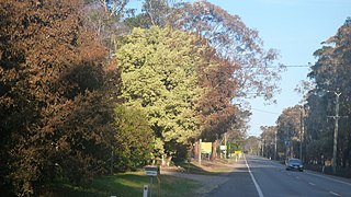
| Description | Heat from burning trees on the opposite side of Richardson Road in Campvale New South Wales, Australia during the the 2013 New South Wales bushfires was high enough to sear leaves on trees and foliage on the fence of properties but caused little other damage. Even the grass remained green. |
| Date | |
| Source | Own work |
| Author | AussieLegend |
| Other versions |
 |
| Camera location | | View this and other nearby images on: OpenStreetMap |
|---|
Licensing
[edit]
| I, the copyright holder of this work, release this work into the public domain. This applies worldwide. In some countries this may not be legally possible; if so: I grant anyone the right to use this work for any purpose, without any conditions, unless such conditions are required by law. |
File history
Click on a date/time to view the file as it appeared at that time.
| Date/Time | Thumbnail | Dimensions | User | Comment | |
|---|---|---|---|---|---|
| current | 13:37, 21 October 2013 | | 4,000 × 2,248 (3.98 MB) | AussieLegend (talk | contribs) | == {{int:filedesc}} == {{Information |description = Heat from burning trees on the opposite side of Richardson Road in Campvale New South Wales, Australia during the the [[:... |
You cannot overwrite this file.
File usage on Commons
The following 2 pages use this file:
File usage on other wikis
The following other wikis use this file:
- Usage on en.wikipedia.org
- Usage on www.wikidata.org