File:Burr The State of Texas, 1835-1845 1846 UTA.jpg

Original file (3,218 × 2,688 pixels, file size: 1.54 MB, MIME type: image/jpeg)
Captions
Captions
Summary[edit]
| Title |
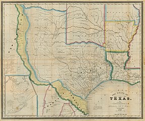
English: The State of Texas, 1836-1845 |
||||||||||||||||||||||||||
| Description |
English: Engraved by S. Stiles & Co.
This historically-themed map is one of the first printed maps to show the former Texas republic and Mexican province as a state, and the map's distinct hand coloring well illustrates disputed areas (in yellow) claimed by both the Texas (and now U.S.) and Mexican governments from the time of Texas independence in 1836 to the eve of the U.S. War with Mexico in 1846. The cartographer, David H. Burr, was geographer to the U.S. House of Representatives (1838-1847) and before that had been topographer to the U.S. Post Office Department (1832-1838). As early as 1833 Burr issued a similar map based in part on Stephen F. Austin's and Henry S. Tanner's 1830 map of Texas. One of Burr's innovations then was to include an inset "Plan of the Port of Galveston, Made by order of the Mexican Government by Alexander Thompson of the Mexican Navy in 1828," seen at lower left. As Texas passed from Mexican province (technically part of the state of Coahuila y Texas) to an independent republic and then a state, Burr continued to update his own maps, but he also kept many of the original features of the first edition. As examples, Burr's 1833 edition had several of the Mexican-Anglo land grants but did not have the counties, the latest addition on this 1846 map being the 1843 addition of Rusk County in the east. In 1846 Burr continued to show a "Spanish Garrison" and a "Cherokee Village" long after these features had disappeared, but he also added newer towns and villages such as Austin, Crockett, and Texana, that had been established during the years of the republic. Burr also noted the location of copper and silver mines in west central Texas, but not enough of these resources were ever found to make commercial mining of them viable. |
||||||||||||||||||||||||||
| Date | |||||||||||||||||||||||||||
| Source | UTA Libraries Cartographic Connections: map / text | ||||||||||||||||||||||||||
| Creator |
|
||||||||||||||||||||||||||
| Credit line |
English: UTA Libraries Special Collections |
||||||||||||||||||||||||||
| Geotemporal data | |||||||||||||||||||||||||||
| Map location | Texas | ||||||||||||||||||||||||||
| Georeferencing | If inappropriate please set warp_status = skip to hide. | ||||||||||||||||||||||||||
| Bibliographic data | |||||||||||||||||||||||||||
| Place of publication | New York City | ||||||||||||||||||||||||||
| Printed by |
R. S. Fisher |
||||||||||||||||||||||||||
| Archival data | |||||||||||||||||||||||||||
| Collection |
|
||||||||||||||||||||||||||
| Dimensions | height: 45.5 cm (17.9 in); width: 54 cm (21.2 in) | ||||||||||||||||||||||||||
| Medium |
colored engraving colored lithograph |
||||||||||||||||||||||||||
| artwork-references |
Martin and Martin Maps of Texas and the Southwest, pp. 122−123 Gournay, Luke (1995) Texas Boundaries: Evolution of the State's Counties, College Station: Texas A&M Press, pp. 31−45 Cohen , ed. Mapping the West, p. 117 |
||||||||||||||||||||||||||
Licensing[edit]

|
This file was provided to Wikimedia Commons by the University of Texas at Arlington Libraries as part of a cooperation project. The University of Texas at Arlington Libraries is part of the University of Texas at Arlington, a public research university located in Arlington, Texas.
|
|
The author died in 1875, so this work is in the public domain in its country of origin and other countries and areas where the copyright term is the author's life plus 100 years or fewer. This work is in the public domain in the United States because it was published (or registered with the U.S. Copyright Office) before January 1, 1929. | |
| This file has been identified as being free of known restrictions under copyright law, including all related and neighboring rights. | |
File history
Click on a date/time to view the file as it appeared at that time.
| Date/Time | Thumbnail | Dimensions | User | Comment | |
|---|---|---|---|---|---|
| current | 17:46, 9 March 2022 | | 3,218 × 2,688 (1.54 MB) | Michael Barera (talk | contribs) | == {{int:filedesc}} == {{Map |title = {{en|'''''The State of Texas, 1836-1845'''''}} |description = {{en|Engraved by S. Stiles & Co. This historically-themed map is one of the first printed maps to show the former Texas republic and Mexican province as a state, and the map's distinct hand coloring well illustrates disputed areas (in yellow) claimed by both the Texas (and now U.S.) and Mexican governments from the time of Texas independence in 1836 to the eve of the U.S. W... |
You cannot overwrite this file.
File usage on Commons
The following page uses this file:
File usage on other wikis
The following other wikis use this file:
- Usage on en.wikipedia.org
- Usage on es.wikipedia.org