File:Byzantine Constantinople-en.svg
跳至導覽
跳至搜尋

此 SVG 檔案的 PNG 預覽的大小:662 × 600 像素。 其他解析度:265 × 240 像素 | 530 × 480 像素 | 848 × 768 像素 | 1,130 × 1,024 像素 | 2,261 × 2,048 像素 | 2,085 × 1,889 像素。
原始檔案 (SVG 檔案,表面大小:2,085 × 1,889 像素,檔案大小:3.69 MB)
說明
說明
添加單行說明來描述出檔案所代表的內容
摘要
[編輯]| 描述 |
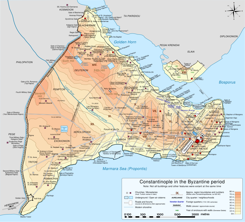
Deutsch: Topografische Karte Konstantinopels während des byzantinischen Zeitraums. Quelle: R. Janin, Constantinople Byzantine. Developpement urbain et repertoire topographique. Straßennetz und andere Einzelheiten basiert auf Dumbarton Oaks Papers 54. Kirchen, insb. nicht identifizierte und ausgegrabene Bauten sind aus dem The Byzantine Churches of Istanbul entnommen. Andere herausgegebenen Quellen wurden behilfsmäßig gebraucht. English: Topographical map of Constantinople during the Byzantine period. Main map source: R. Janin, Constantinople Byzantine. Developpement urbain et repertoire topographique. Road network and some other details based on Dumbarton Oaks Papers 54; data on many churches, especially unidentified ones, taken from the University of New York's The Byzantine Churches of Istanbul project. Other published maps and accounts of the city have been used for corroboration. Français : Carte en anglais de Constantinople à l'époque Byzantine. Source principale : R. Janin, Constantinople Byzantine. Développement urbain et répertoire topographique. Le réseau routier et d'autres détails proviennent de Dumbarton Oaks Papers 54. Les données concernant de nombreuses églises, en particulier celles non identifiées, viennent de l'université de New York : le projet The Byzantine Churches of Istanbul (Les églises byzantines d'Istanbul). D'autres cartes encore ont été utilisées pour recouper et vérifier les informations. Türkçe: tr:Konstantinopolis'in Bizans dönemindeki topografik haritası. Ana haritanın kaynağı: R. Janin, Constantinople Byzantine. Developpement urbain et repertoire topographique. Yol haritası ve bazı diğer ayrıntıların kaynağı: Dumbarton Oaks Papers 54; kiliseler, özellikle kimliği belirlenmemiş olanlar hakkında veriler, New York University'nin İstanbul'un Bizans Kiliseleri projesinden elde edilmiştir. Şehir hakkında yayımlanmış diğer harita ve metinler bu bilgileri doğrulamak için kullanılmıştır. Ελληνικά: Τοπογραφικός χάρτης Κωνσταντινουπόλεως κατά τη Βυζαντινή περίοδο. Βασική πηγή χάρτη: R. Janin, Constantinople Byzantine. Developpement urbain et repertoire topographique. Το οδικό δίκτυο και διάφορες άλλες λεπτομέρειες με βάση το Dumbarton Oaks Papers 54. Πληροφορίες για τις εκκλησίες, ιδιαίτερα τις μη ταυτοποιημένες, από την ιστοσελίδα The Byzantine Churches of Istanbul του Πανεπιστημίου της Νέας Υόρκης. Български: Топографска карта на Константинопол (Цариград) през византийския период. Източник: R. Janin, Constantinople Byzantine. Developpement urbain et repertoire topographique. Пътната мрежа и някои други детайли се основават на Dumbarton Oaks Papers 54 и други публикувани източници. |
||
| 日期 | |||
| 來源 | 自己的作品 | ||
| 作者 | Cplakidas | ||
| 其他版本 |
[] Full maps[編輯]SVG:
PNG:
Numeric versions[編輯]
Regions[編輯]
Roads[編輯]
Derivative works of this file: | ||
| SVG | W3C-validity not checked.
|


| 拍攝地點 | | 位於此地的本圖片與其他圖片: OpenStreetMap |
|---|
授權條款
[編輯]
我,本作品的著作權持有者,決定用以下授權條款發佈本作品:
此檔案採用共享創意 姓名標示-相同方式分享 3.0 未在地化版本授權條款。
- 您可以自由:
- 分享 – 複製、發佈和傳播本作品
- 重新修改 – 創作演繹作品
- 惟需遵照下列條件:
- 姓名標示 – 您必須指名出正確的製作者,和提供授權條款的連結,以及表示是否有對內容上做出變更。您可以用任何合理的方式來行動,但不得以任何方式表明授權條款是對您許可或是由您所使用。
- 相同方式分享 – 如果您利用本素材進行再混合、轉換或創作,您必須基於如同原先的相同或兼容的條款,來分布您的貢獻成品。

|
已授權您依據自由軟體基金會發行的無固定段落、封面文字和封底文字GNU自由文件授權條款1.2版或任意後續版本,對本檔進行複製、傳播和/或修改。該協議的副本列在GNU自由文件授權條款中。 |
您可以選擇您需要的授權條款。
檔案歷史
點選日期/時間以檢視該時間的檔案版本。
| 日期/時間 | 縮圖 | 尺寸 | 用戶 | 備註 | |
|---|---|---|---|---|---|
| 目前 | 2012年3月13日 (二) 20:48 | | 2,085 × 1,889(3.69 MB) | Sémhur(對話 | 貢獻) | New version, with cleaned code and a new layer "editable text, hidden" made with font "Nimbus Sans L", containing all the texts, and other layers with text as path (not editables, but visibles). |
| 2009年12月15日 (二) 13:13 |  | 2,050 × 1,850(8.13 MB) | Cplakidas(對話 | 貢獻) | larger & improved version, various corrections, Galata included | |
| 2009年1月8日 (四) 22:53 |  | 1,600 × 1,500(5.79 MB) | Cplakidas(對話 | 貢獻) | {{Information |Description= |Source= |Date= |Author= |Permission= |other_versions= }} | |
| 2008年11月14日 (五) 23:26 |  | 1,600 × 1,500(5.29 MB) | Cplakidas(對話 | 貢獻) | attempt to get text right | |
| 2008年10月28日 (二) 11:38 |  | 1,600 × 1,500(5.31 MB) | Cplakidas(對話 | 貢獻) | final version (hopefully): added remaining churches & corrected locations, minor tweaks at places | |
| 2008年10月27日 (一) 19:10 |  | 1,600 × 1,500(4.81 MB) | Cplakidas(對話 | 貢獻) | completed outer land wall, fixed Golden Gate, fixed sea walls & added known gates, minor location corrections & additions | |
| 2008年10月25日 (六) 17:46 |  | 1,600 × 1,500(2.74 MB) | Cplakidas(對話 | 貢獻) | text into paths, enlarged map for improved readability | |
| 2008年10月24日 (五) 00:59 |  | 1,180 × 1,120(371 KB) | Cplakidas(對話 | 貢獻) | restored Times New Roman. | |
| 2008年10月24日 (五) 00:39 |  | 1,180 × 1,120(369 KB) | Cplakidas(對話 | 貢獻) | added posterns, alternate gate names, approx. roads in outer city, corrections on monastery locations, converted text to sans serif font | |
| 2008年10月23日 (四) 22:47 |  | 1,180 × 1,120(328 KB) | Cplakidas(對話 | 貢獻) | Reverted to version as of 23:25, 14 October 2008 |
無法覆蓋此檔案。
檔案用途
下列18個頁面有用到此檔案:
- File:Byzantine Constantinople-de.svg
- File:Byzantine Constantinople-el.svg
- File:Byzantine Constantinople-en.png
- File:Byzantine Constantinople-en.svg
- File:Byzantine Constantinople-pt.svg
- File:Byzantine Constantinople-tr.png
- File:Byzantine Constantinople-tr.svg
- File:Byzantine Constantinople.svg (檔案重新導向)
- File:Byzantine Constantinople - ce.svg
- File:Byzantine Constantinople - ru.svg
- File:Byzantine Constantinople - uk.svg
- File:Byzantine Constantinople eu.png
- File:Byzantine Constantinople eu.svg
- File:Byzantine Constantinople regiones.svg
- File:Byzantine Constantinople viae.svg
- File:Karte Eroberung Konstantinopel 1453.png
- File:Karte Eroberung Konstantinopels 1453.svg
- Template:Other versions/Byzantine Constantinople versions
全域檔案使用狀況
以下其他 wiki 使用了這個檔案:
- ca.wikipedia.org 的使用狀況
- cs.wikipedia.org 的使用狀況
- en.wikipedia.org 的使用狀況
- es.wikipedia.org 的使用狀況
- fr.wikipedia.org 的使用狀況
- it.wikipedia.org 的使用狀況
- pl.wikipedia.org 的使用狀況
- sw.wikipedia.org 的使用狀況