File:Côté Est de la basilique d'Ars.JPG
Original file (4,320 × 3,240 pixels, file size: 5.72 MB, MIME type: image/jpeg)
Captions
Summary[edit]
DescriptionCôté Est de la basilique d'Ars.JPG |
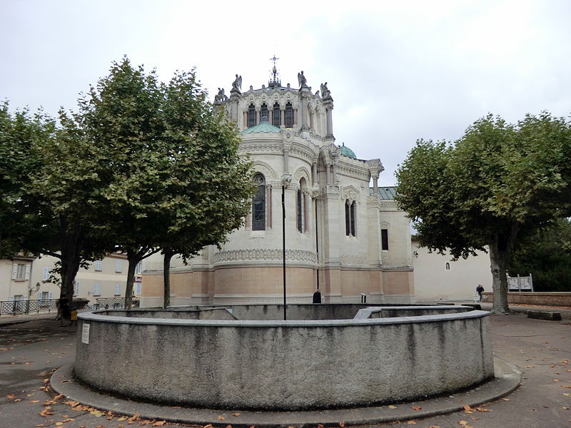
Français : Côté Est de la basilique d'Ars. Au premier plan, l'entrée de l'église souterraine de Notre-Dame-de-la-Miséricorde.
|
|||||||||||||||||
Date | ||||||||||||||||||
Source | Own work | |||||||||||||||||
Author |
creator QS:P170,Q42790984 |
Camera location | 45° 59′ 32.53″ N, 4° 49′ 24.9″ E | View this and other nearby images on: OpenStreetMap | 45.992370; 4.823583 |
---|
Licensing[edit]
This file is made available under the Creative Commons CC0 1.0 Universal Public Domain Dedication. | |
The person who associated a work with this deed has dedicated the work to the public domain by waiving all of their rights to the work worldwide under copyright law, including all related and neighboring rights, to the extent allowed by law. You can copy, modify, distribute and perform the work, even for commercial purposes, all without asking permission.
http://creativecommons.org/publicdomain/zero/1.0/deed.enCC0Creative Commons Zero, Public Domain Dedicationfalsefalse |
This image was uploaded as part of Wiki Loves Monuments 2013.
Afrikaans ∙ Alemannisch ∙ azərbaycanca ∙ Bahasa Indonesia ∙ Bahasa Melayu ∙ Bikol Central ∙ bosanski ∙ brezhoneg ∙ català ∙ čeština ∙ Cymraeg ∙ dansk ∙ davvisámegiella ∙ Deutsch ∙ eesti ∙ English ∙ español ∙ Esperanto ∙ euskara ∙ français ∙ Frysk ∙ Gaeilge ∙ galego ∙ hrvatski ∙ Ido ∙ italiano ∙ latviešu ∙ Lëtzebuergesch ∙ Malagasy ∙ magyar ∙ Malti ∙ Nederlands ∙ norsk ∙ norsk nynorsk ∙ norsk bokmål ∙ polski ∙ português ∙ português do Brasil ∙ română ∙ shqip ∙ sicilianu ∙ slovenčina ∙ slovenščina ∙ suomi ∙ svenska ∙ Tagalog ∙ Türkçe ∙ Yorùbá ∙ Zazaki ∙ Ελληνικά ∙ беларуская ∙ беларуская (тарашкевіца) ∙ български ∙ кыргызча ∙ македонски ∙ русский ∙ српски / srpski ∙ українська ∙ ქართული ∙ հայերեն ∙ नेपाली ∙ हिन्दी ∙ বাংলা ∙ മലയാളം ∙ ไทย ∙ 한국어 ∙ +/− |
File history
Click on a date/time to view the file as it appeared at that time.
Date/Time | Thumbnail | Dimensions | User | Comment | |
---|---|---|---|---|---|
current | 06:56, 9 September 2013 | 4,320 × 3,240 (5.72 MB) | Benoît Prieur (talk | contribs) | User created page with UploadWizard |
You cannot overwrite this file.
File usage on Commons
There are no pages that use this file.
File usage on other wikis
The following other wikis use this file:
- Usage on fa.wikipedia.org
- Usage on fr.wikipedia.org
- Usage on ur.wikipedia.org
Metadata
This file contains additional information such as Exif metadata which may have been added by the digital camera, scanner, or software program used to create or digitize it. If the file has been modified from its original state, some details such as the timestamp may not fully reflect those of the original file. The timestamp is only as accurate as the clock in the camera, and it may be completely wrong.
Camera manufacturer | CASIO COMPUTER CO.,LTD. |
---|---|
Camera model | EX-H20G |
Author | Picasa |
Exposure time | 1/160 sec (0.00625) |
F-number | f/3.2 |
ISO speed rating | 80 |
Date and time of data generation | 15:14, 7 September 2013 |
Lens focal length | 4.3 mm |
Latitude | 45° 59′ 32.53″ N |
Longitude | 4° 49′ 24.9″ E |
Altitude | 254.7 meters above sea level |
Horizontal resolution | 72 dpi |
Vertical resolution | 72 dpi |
Software used | 1.04 |
File change date and time | 04:12, 9 September 2013 |
Y and C positioning | Co-sited |
Exposure Program | Normal program |
Exif version | 2.3 |
Date and time of digitizing | 15:14, 7 September 2013 |
Meaning of each component |
|
Image compression mode | 5.4489254686786 |
APEX exposure bias | 0 |
Maximum land aperture | 3.4 APEX (f/3.25) |
Metering mode | Pattern |
Light source | Unknown |
Flash | Flash did not fire, compulsory flash suppression |
Supported Flashpix version | 1 |
Color space | sRGB |
File source | Digital still camera |
Custom image processing | Normal process |
Exposure mode | Auto exposure |
White balance | Auto white balance |
Focal length in 35 mm film | 24 mm |
Scene capture type | Standard |
Scene control | None |
Contrast | Normal |
Saturation | Normal |
Sharpness | Normal |
Unique image ID | b460b36c72f8aac90551c0209ce81580 |
GPS time (atomic clock) | 13:23 |
Satellites used for measurement | 11 |
Receiver status | Measurement in progress |
Measurement precision | Excellent (0) |
Reference for direction of image | True direction |
Direction of image | 256 |
Geodetic survey data used | WGS-84 |
GPS date | 8 September 2013 |
GPS differential correction | 1 |
GPS tag version | 2.3.0.0 |
IIM version | 4 |
Structured data
Items portrayed in this file
depicts
7 September 2013
45°59'32.53200"N, 4°49'24.89999"E
image/jpeg
0fa145268dacc87e3e4a2eac4cf297641547fa3c
5,999,044 byte
3,240 pixel
4,320 pixel
- Base Mérimée
- Monuments historiques classés
- Mérimée with PA parameter
- Cultural heritage monuments in France with known IDs
- CC-Zero
- Self-published work
- Images from Wiki Loves Monuments 2013
- Images from Wiki Loves Monuments 2013 in France
- Uploaded via Campaign:wlm-fr
- Images of Ars-sur-Formans by Benoît Prieur
- Photographs by Benoît Prieur
- Wiki Loves Monuments 2013 by Benoît Prieur
- France photographs taken on 2013-09-07
- 2013 images by Benoît Prieur
- Pages with maps