File:C78198s1 Ant.Map Mount Harmsworth.jpg
Pāriet uz navigāciju
Pāriet uz meklēšanu
Šī priekšskata izmērs: 710 × 600 pikseļi. Citi izmēri: 284 × 240 pikseļi | 568 × 480 pikseļi | 909 × 768 pikseļi | 1 212 × 1 024 pikseļi | 2 424 × 2 048 pikseļi | 3 849 × 3 252 pikseļi.
Sākotnējais fails (3 849 × 3 252 pikseļi, faila izmērs: 1,69 MB, MIME tips: image/jpeg)
Captions
Captions
Pievieno vienas rindiņas aprakstu, ko šis fails attēlo
Kopsavilkums[labot šo sadaļu]
| Apraksts |
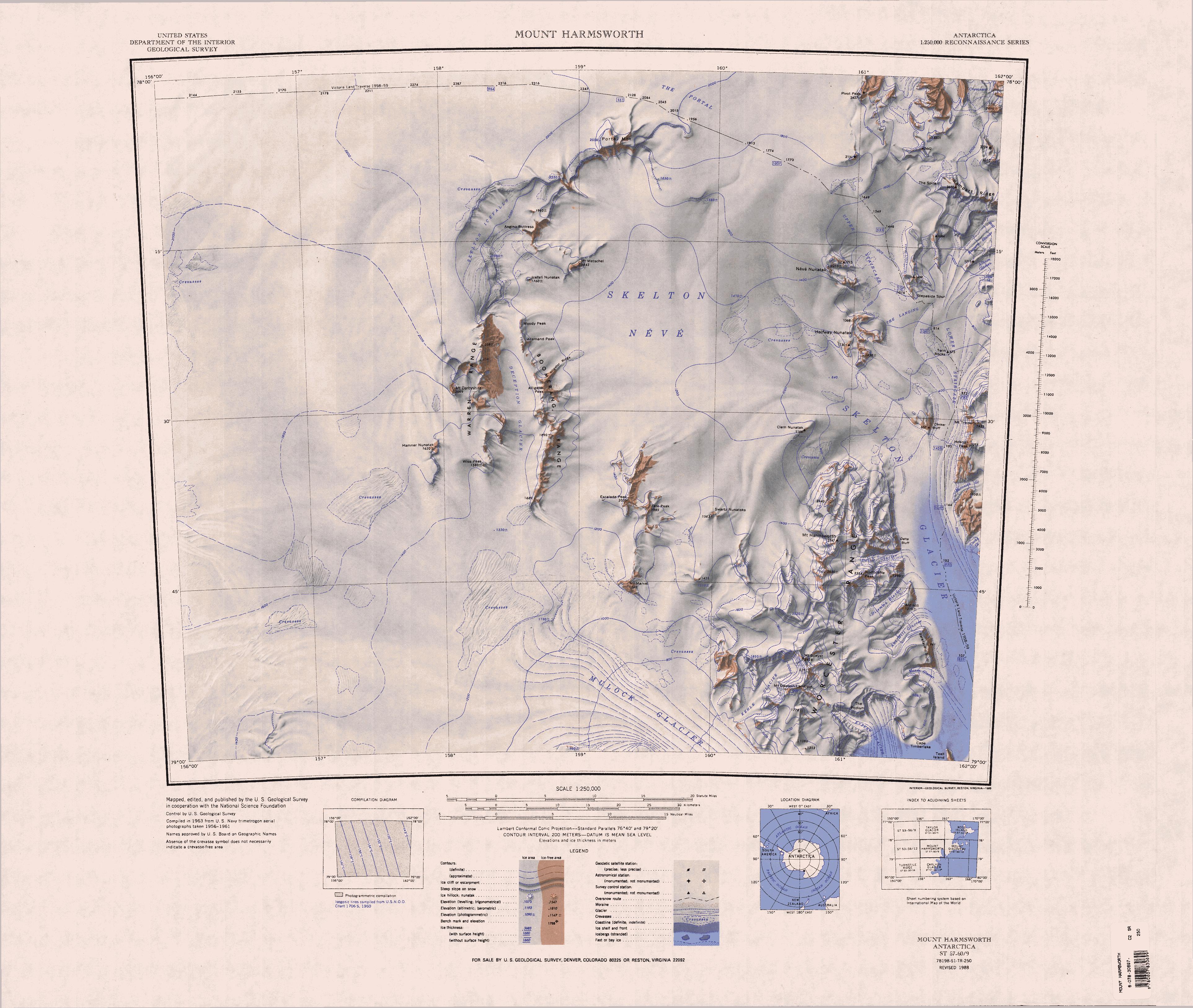
English: 1:250,000-scale topographic reconnaissance map of the Mount Harmsworth area from 156°-162'E to 78°-79°S in Antarctica. Mapped, edited and published by the U.S. Geological Survey in cooperation with the National Science Foundation. |
|||
| Datums | ||||
| Avots | http://usarc.usgs.gov/drg_dload.shtml | |||
| Autors | United States Geological Survey | |||
| Atļauja: (Šī faila izmantošana citur) |
|
Faila hronoloģija
Uzklikšķini uz datums/laiks kolonnā esošās saites, lai apskatītos, kā šis fails izskatījās tad.
| Datums/Laiks | Attēls | Izmēri | Dalībnieks | Komentārs | |
|---|---|---|---|---|---|
| tagadējais | 2013. gada 17. aprīlis, plkst. 13.34 | | 3 849 × 3 252 (1,69 MB) | 4ing (diskusija | devums) | == {{int:filedesc}} == {{Information |description={{en|1=1:250,000-scale topographic reconnaissance map of the Mount Harmsworth area from 156°-162'E to 78°-79°S in Antarctica. Mapped, edited and published by the U.S. Geological Survey in cooperation... |
Šo failu nevar pārrakstīt.
Faila lietojums
Šo failu neizmanto nevienā lapā.
Globālais faila lietojums
Šīs Vikipēdijas izmanto šo failu:
- Izmantojums bg.wikipedia.org
- Izmantojums de.wikipedia.org
- Skelton-Gletscher
- Mulock-Gletscher
- The Portal
- Portal Mountain
- Skelton-Firnfeld
- Allemand Peak
- Moody Peak
- Boomerang Range
- Alligator Peak
- Alligator Ridge
- Skelton-Eisfälle
- Warren Range
- Ant Hill
- Ant-Hill-Gletscher
- Dilemma-Gletscher
- Worcester Range
- Bareface Bluff
- Mount Harmsworth
- Mason-Gletscher
- Delta-Gletscher
- Delta Bluff
- Northcliffe Peak
- Wilkniss Mountains
- Pivot Peak
- Halfway-Nunatak
- Rampart Ridge
- Deception-Gletscher
- Mount Dawson-Lambton
- Mount Speyer
- Kehle-Gletscher
- Escalade Peak
- Hamner-Nunatak
- Wise Peak
- Icefall Nunatak (Süden)
- Mount Marvel
- Mount Metschel
- Swartz-Nunatakker
- Tate Peak
- Van Allen Range
- Ross-Orogen
- Izmantojums en.wikipedia.org
Skatīt šī faila pilno globālo izmantojumu.