File:CARNIAN EARTH.jpg
Jump to navigation
Jump to search
No higher resolution available.
CARNIAN_EARTH.jpg (720 × 540 pixels, file size: 126 KB, MIME type: image/jpeg)
Captions
Captions
Add a one-line explanation of what this file represents

|
This geology image could be re-created using vector graphics as an SVG file. This has several advantages; see Commons:Media for cleanup for more information. If an SVG form of this image is available, please upload it and afterwards replace this template with
{{vector version available|new image name}}.
It is recommended to name the SVG file “CARNIAN EARTH.svg”—then the template Vector version available (or Vva) does not need the new image name parameter. |


Summary[edit]
| Description |
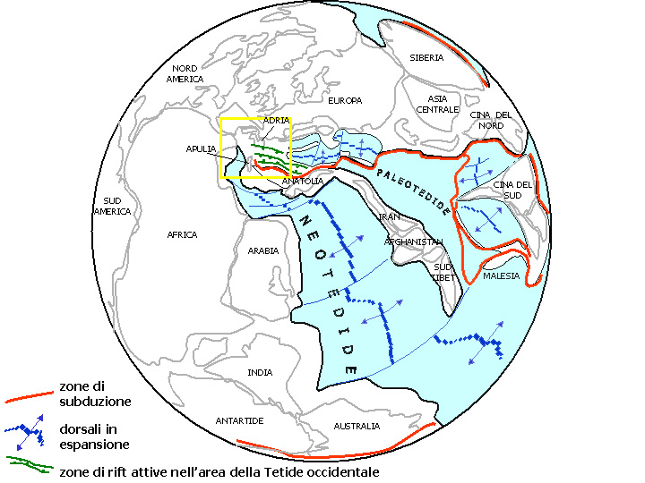
Deutsch: Obetrias, Karnium- ca.220 mya: Die westliche (Neo-)Tethys teilt die östliche Pangea.
Italiano: Rappresentazione della Terra al passaggio Ladinico-Carnico. Prosegue l'espansione della Neotetide e le micro-placche cimmeriche si avvicinano al margine settentrionale della Paleotetide, ormai molto ridotta. La subduzione di crosta oceanica al margine occidentale della Paleotetide è probabilmente all'origine di un vulcanismo di arco nell'area delle attuali Alpi Meridionali. Nel settore nord-occidentale della Tetide si individuano nuovi piccoli bacini oceanici in fase di espansione. Un sistema di rift attivo interessa l'area corrispondente alla micro-placca Adria almeno dal Triassico Medio. Stampfli e Borel, 2002. Modificato. |
| Source | Stampfli & Borel (2002), modified |
| Author | Antonov |
Licensing[edit]
| I, the copyright holder of this work, release this work into the public domain. This applies worldwide. In some countries this may not be legally possible; if so: I grant anyone the right to use this work for any purpose, without any conditions, unless such conditions are required by law. |
File history
Click on a date/time to view the file as it appeared at that time.
| Date/Time | Thumbnail | Dimensions | User | Comment | |
|---|---|---|---|---|---|
| current | 17:19, 18 November 2007 | | 720 × 540 (126 KB) | Antonov (talk | contribs) | {{Information |Description= |Source= Stampfli & Borel (2002), modified |Date= |Author= |Permission= |other_versions= }} |
You cannot overwrite this file.
File usage on Commons
There are no pages that use this file.
File usage on other wikis
The following other wikis use this file:
- Usage on ar.wikipedia.org
- Usage on de.wikipedia.org
- Usage on en.wikipedia.org
- Usage on fr.wikipedia.org
- Usage on hu.wikipedia.org
- Usage on it.wikipedia.org
- Usage on sl.wikipedia.org