File:CARTE DE LA RÉGION NATURELLE DU PERCHE.png
Jump to navigation
Jump to search

Size of this preview: 800 × 566 pixels. Other resolutions: 320 × 226 pixels | 640 × 453 pixels | 1,024 × 724 pixels | 1,280 × 905 pixels | 2,560 × 1,811 pixels | 3,508 × 2,481 pixels.
Original file (3,508 × 2,481 pixels, file size: 396 KB, MIME type: image/png)
Captions
Captions
Add a one-line explanation of what this file represents
Summary[edit]
| Description |
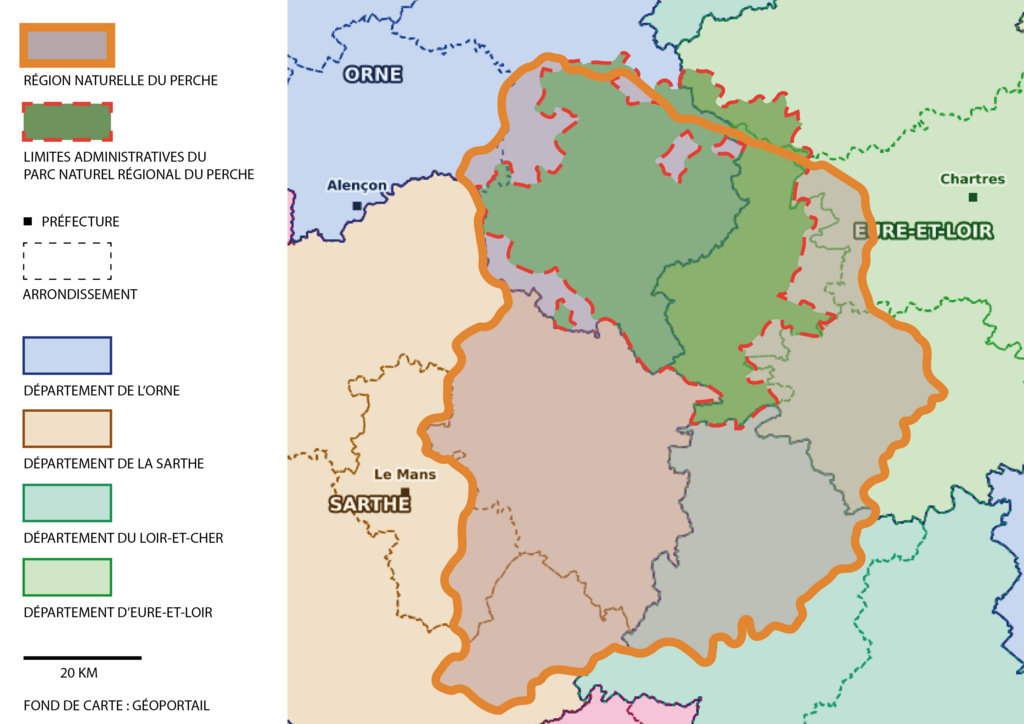
Français : Représentation de la région naturelle du Perche dans les limites suivantes :
- Au Nord : la rivière de l'Eure et la Marche du Thymerais et du Pays d'Ouche(frontière entre les bassins hydrographiques de Seine-Normandie et Loire-Bretagne) - Au Nord-Ouest : la rivière de La Sarthe et la Campagne d'Alençon - A l'Ouest : Le Saosnois (partie nord) et le Pays Manceau - Au Sud : la rivière du Loir, le Maine angevin et la Gâtine Tourangelle - A l'Est : La rivière du Loir et la Beauce Les limites du PNR du Perche sont prises en compte dans les limites des Communes établies selon le scrutin municipal de 2020 et non selon le Décret n° 2020-1080 du 21 août 2020 modifiant le décret n° 2010-8 du 6 janvier 2010 portant renouvellement du classement du parc naturel régional du Perche, notamment pour les communes de Tourouvre-au-Perche et Val-au-Perche. |
| Date | |
| Source | Own work |
| Author | Dagh08 |
Licensing[edit]
I, the copyright holder of this work, hereby publish it under the following license:
This file is licensed under the Creative Commons Attribution-Share Alike 4.0 International license.
- You are free:
- to share – to copy, distribute and transmit the work
- to remix – to adapt the work
- Under the following conditions:
- attribution – You must give appropriate credit, provide a link to the license, and indicate if changes were made. You may do so in any reasonable manner, but not in any way that suggests the licensor endorses you or your use.
- share alike – If you remix, transform, or build upon the material, you must distribute your contributions under the same or compatible license as the original.
File history
Click on a date/time to view the file as it appeared at that time.
| Date/Time | Thumbnail | Dimensions | User | Comment | |
|---|---|---|---|---|---|
| current | 12:12, 4 October 2020 | | 3,508 × 2,481 (396 KB) | Dagh08 (talk | contribs) | Uploaded own work with UploadWizard |
You cannot overwrite this file.
File usage on Commons
There are no pages that use this file.
File usage on other wikis
The following other wikis use this file:
- Usage on es.wikipedia.org
- Usage on fr.wikipedia.org
- Usage on zh.wikipedia.org