File:Cadastral map of Quebec city region, 1709.jpg
Aller à la navigation
Aller à la recherche

Taille de cet aperçu : 800 × 573 pixels. Autres résolutions : 320 × 229 pixels | 640 × 459 pixels | 1 024 × 734 pixels | 1 280 × 917 pixels | 2 560 × 1 834 pixels | 5 000 × 3 583 pixels.
Fichier d’origine (5 000 × 3 583 pixels, taille du fichier : 2,86 Mio, type MIME : image/jpeg)
Légendes
Légendes
Ajoutez en une ligne la description de ce que représente ce fichier
Description
[modifier]
| Description |
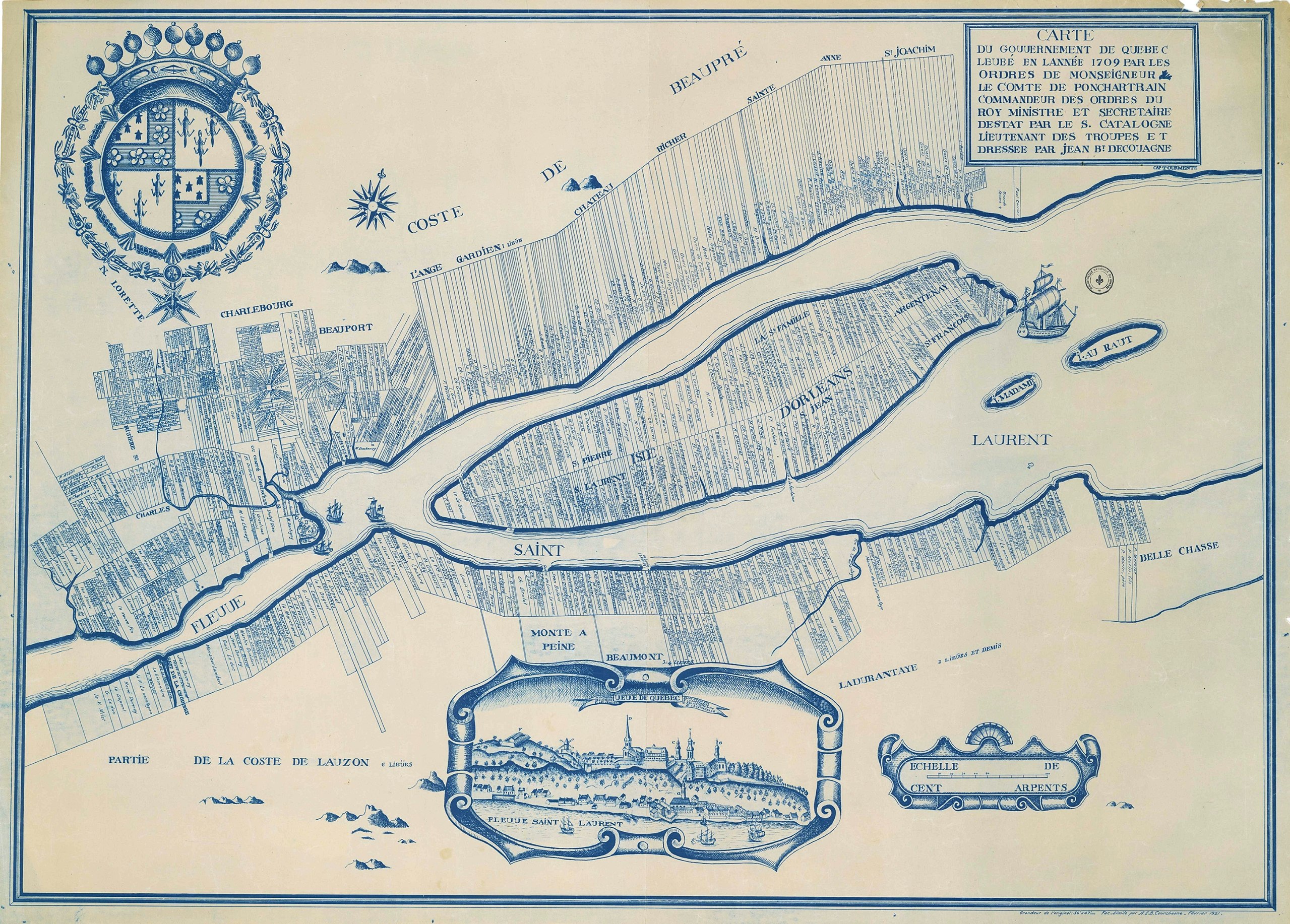
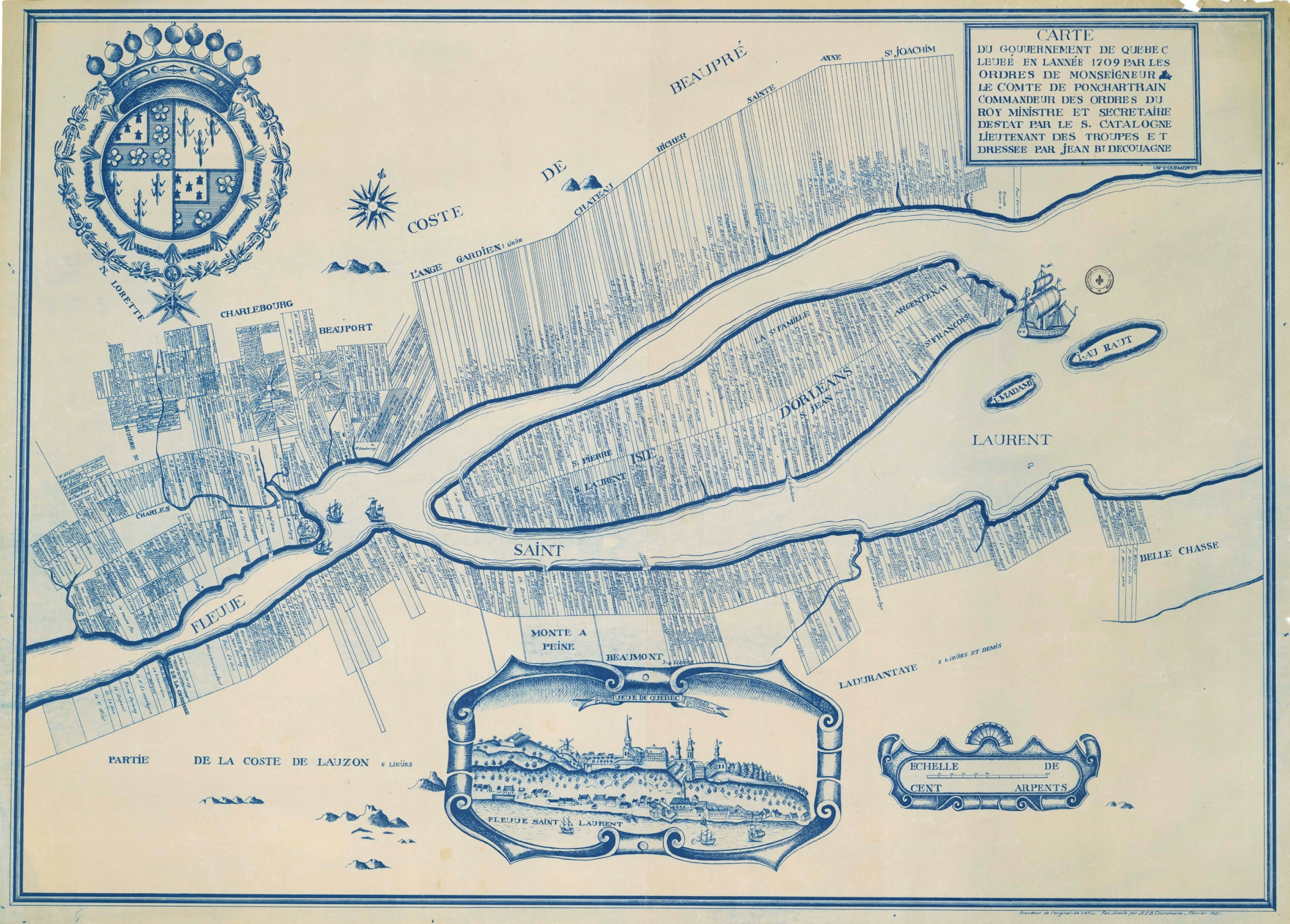
English: Cadastral map of Québec city region, 1709, from Bibliothèque et Archives nationales du Québec (BAnQ)
Français : Carte du gouvernement de Québec levée en l'année 1709 par les ordres de Monseigneur le Comte de Ponchartrain commandeur des ordres du Roy ministre et secrétaire d'estat / par le Sr. Catalogne lieutenant des troupes ; et dressée par Jean Bte Decoüagne |
| Date | |
| Source | http://arslanmb.org/fortier/Map-PQ-QuebecCityEnvirons-1709.jpg |
| Auteur | Gédéon de Catalogne |
Conditions d’utilisation
[modifier]
|
Cette œuvre est également dans le domaine public dans tous les pays pour lesquels le droit d’auteur a une durée de vie de 100 ans ou moins après la mort de l’auteur. | |
| Ce fichier a été identifié comme étant exempt de restrictions connues liées au droit d’auteur, y compris tous les droits connexes et voisins. | |
Historique du fichier
Cliquer sur une date et heure pour voir le fichier tel qu'il était à ce moment-là.
| Date et heure | Vignette | Dimensions | Utilisateur | Commentaire | |
|---|---|---|---|---|---|
| actuel | 15 septembre 2016 à 19:48 | | 5 000 × 3 583 (2,86 Mio) | Jeangagnon (d | contributions) | {{Information |Description ={{en|1=Cadastral map of Québec city region, 1709, from Bibliothèque et Archives nationales du Québec (BAnQ)}} |Source =http://arslanmb.org/fortier/Map-PQ-QuebecCityEnvirons-1709.jpg |Author =Gédéon de... |
Vous ne pouvez pas remplacer ce fichier.
Utilisations locales du fichier
Aucune page n’utilise ce fichier.
Utilisations du fichier sur d’autres wikis
Les autres wikis suivants utilisent ce fichier :
- Utilisation sur fr.wikipedia.org