File:Cajon Boulevard, Devore, California (2010-01-30)-01.jpg
Jump to navigation
Jump to search
No higher resolution available.
Cajon_Boulevard,_Devore,_California_(2010-01-30)-01.jpg (500 × 375 pixels, file size: 54 KB, MIME type: image/jpeg)
Captions
Captions
Add a one-line explanation of what this file represents
Summary[edit]
-01.jpg&action=edit§ion=1)
| Description |
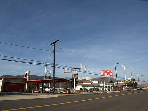
English: Roadside businesses along Cajon Boulevard (formerly U.S. Route 66) in the neighborhood of Devore in San Bernardino, California. This segment of Cajon Boulevard was originally part of the U.S. Route 66 (later renamed U.S. Route 66/91/395) alignment until the late 1960s when Interstate 215 (originally named Interstate 15/15E) was built to bypass the existing route. The building in the middle of the picture, Tony's Diner restaurant (18291 Cajon Blvd.), was built in 1967. {1} View from the northbound lane of Cajon Boulevard looking west-northwest. This photograph was taken with an Olympus E-510 DSLR camera and edited (sharpness) using ArcSoft PhotoStudio 5.5) |
| Source | Own work |
| Author | Amin Eshaiker |
| Permission (Reusing this file) |
If you use this photograph outside Wikimedia, I would highly appreciate if you let me know by email or on my talk page, as I'm curious where my work is used. |
| Other versions | Derivative works of this file: Cajon Boulevard, Devore, California (2010-01-30) (crop)-01.jpg |
_(crop)-01.jpg)
| Camera location | | View this and other nearby images on: OpenStreetMap |
|---|
-01.jpg¶ms=034.222179_N_-117.404585_E_globe:Earth_type:camera_type:landmark_region:US-CA_scale:50_heading:315.00&language=en)
| This is a retouched picture, which means that it has been digitally altered from its original version. Modifications: sharpness. Modifications made by Amineshaker.
|
Licensing[edit]
-01.jpg&action=edit§ion=2)
I, the copyright holder of this work, hereby publish it under the following licenses:
This file is licensed under the Creative Commons Attribution-Share Alike 3.0 Unported license.
- You are free:
- to share – to copy, distribute and transmit the work
- to remix – to adapt the work
- Under the following conditions:
- attribution – You must give appropriate credit, provide a link to the license, and indicate if changes were made. You may do so in any reasonable manner, but not in any way that suggests the licensor endorses you or your use.
- share alike – If you remix, transform, or build upon the material, you must distribute your contributions under the same or compatible license as the original.

|
Permission is granted to copy, distribute and/or modify this document under the terms of the GNU Free Documentation License, Version 1.2 or any later version published by the Free Software Foundation; with no Invariant Sections, no Front-Cover Texts, and no Back-Cover Texts. A copy of the license is included in the section entitled GNU Free Documentation License. |
You may select the license of your choice.
File history
Click on a date/time to view the file as it appeared at that time.
| Date/Time | Thumbnail | Dimensions | User | Comment | |
|---|---|---|---|---|---|
| current | 03:01, 20 July 2012 | | 500 × 375 (54 KB) | Amineshaker (talk | contribs) | {{Information |Description ={{en|1=Roadside businesses along Cajon Boulevard (formerly U.S. Route 66) in the neighborhood of Devore in [[San Bernardino, California|San Bernardino, Cali... |
You cannot overwrite this file.
File usage on Commons
The following page uses this file:
-01.jpg&oldid=845550008)