File:Caldern Deutschordenswald hstam karten nr p iii 720.jpg
Jump to navigation
Jump to search

Size of this preview: 697 × 600 pixels. Other resolutions: 279 × 240 pixels | 558 × 480 pixels | 892 × 768 pixels | 1,190 × 1,024 pixels | 2,380 × 2,048 pixels | 3,000 × 2,582 pixels.
Original file (3,000 × 2,582 pixels, file size: 1.13 MB, MIME type: image/jpeg)
Captions
Captions
Add a one-line explanation of what this file represents
Summary
[edit]
| Description |
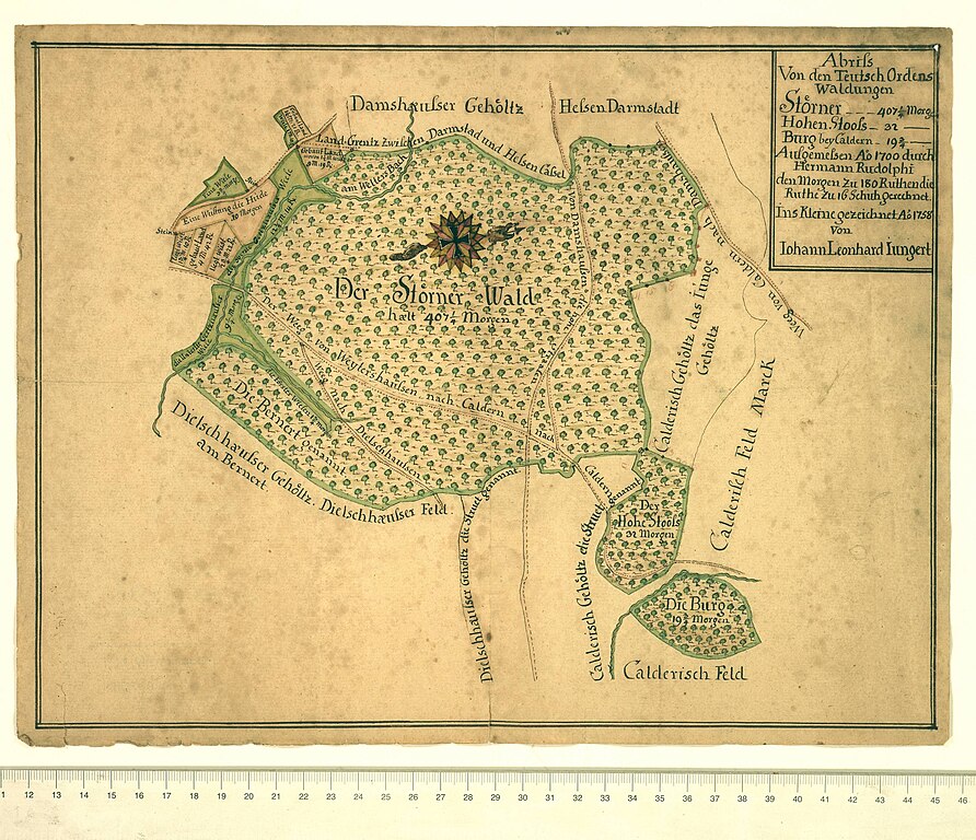
Deutsch: Karte / Plan: Abriß der Deutsch-Ordens-Wälder Stornacker (Störner), Hoher Stoß und Burg bei Caldern. |
| Date | / 1758 |
| Source | Hessisches Staatsarchiv Marburg, Karten P III 720 |
| Author | Hermann Rudolphi (Vermesser), Johann Leonhard Jüngert (Zeichner) |
| Permission (Reusing this file) |
Digitalisierung durch Hessisches Staatsarchiv Marburg. |
Licensing
[edit]
|
This work is in the public domain in its country of origin and other countries and areas where the copyright term is the author's life plus 100 years or fewer. This work is in the public domain in the United States because it was published (or registered with the U.S. Copyright Office) before January 1, 1929. | |
| This file has been identified as being free of known restrictions under copyright law, including all related and neighboring rights. | |
| Annotations | This image is annotated: View the annotations at Commons |
File history
Click on a date/time to view the file as it appeared at that time.
| Date/Time | Thumbnail | Dimensions | User | Comment | |
|---|---|---|---|---|---|
| current | 06:03, 30 August 2022 | | 3,000 × 2,582 (1.13 MB) | HeinrichStuerzl (talk | contribs) | {{Information |description={{de|1=Karte / Plan: Abriß der Deutsch-Ordens-Wälder Stornacker (Störner), Hoher Stoß und Burg bei Caldern.}} |date=1758 |source= Hessisches Staatsarchiv Marburg, [https://arcinsys.hessen.de/arcinsys/detailAction?detailid=v4812335 Karten P III 720] |author=Johann Leonhard Jüngert |permission=Digitalisierung durch Hessisches Staatsarchiv Marburg. |other_versions= }} =={{int:license-header}}== {{PD-old-100-1923}} Category:Burg Caldern Category:Damshausen [[... |
You cannot overwrite this file.
File usage on Commons
The following 3 pages use this file: