File:Camp du Larzac.jpg
Jump to navigation
Jump to search

Size of this preview: 800 × 521 pixels. Other resolutions: 320 × 208 pixels | 640 × 417 pixels | 1,103 × 718 pixels.
Original file (1,103 × 718 pixels, file size: 452 KB, MIME type: image/jpeg)
Captions
Captions
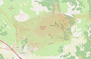
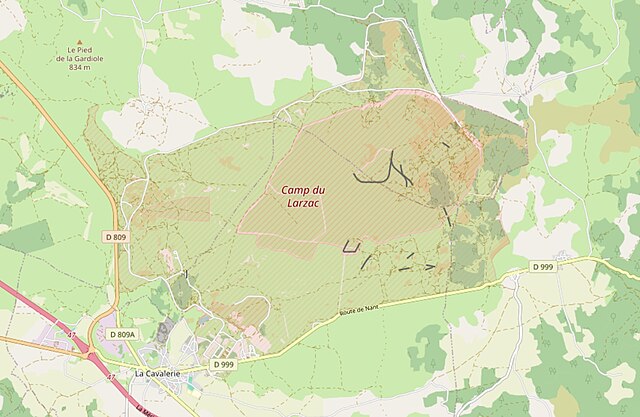
Site of the Camp du Larzac near La Cavalerie
Summary[edit]
| Description |
Deutsch: Die Karte zeigt in etwa die Größe des unter dem Namen Camp du Larzac bekannten militärischen Gelände auf der Hochebene der Causse du Larzac.
English: The map shows approximately the size of the military site known as Camp du Larzac on the Causse du Larzac plateau.
Français : La carte représente approximativement la taille du terrain militaire connu sous le nom de Camp du Larzac sur le plateau du Causse du Larzac. |
|||||||||||||||
| Date | ||||||||||||||||
| Source |
Own work Karte von
|
|||||||||||||||
| Author | Der wilde bernd | |||||||||||||||
| Permission (Reusing this file) |
OpenStreetMap-Daten sind unter der Open Database-Lizenz (Details) erhältlich. Kartenausschnitte unterliegen der Creative Commons „Namensnennung – Weitergabe unter gleichen Bedingungen 2.0“ (CC-BY-SA 2.0)-Lizenz. |
| Camera location | | View this and other nearby images on: OpenStreetMap |
|---|
Licensing[edit]
I, the copyright holder of this work, hereby publish it under the following license:
This file is licensed under the Creative Commons Attribution-Share Alike 4.0 International license.
- You are free:
- to share – to copy, distribute and transmit the work
- to remix – to adapt the work
- Under the following conditions:
- attribution – You must give appropriate credit, provide a link to the license, and indicate if changes were made. You may do so in any reasonable manner, but not in any way that suggests the licensor endorses you or your use.
- share alike – If you remix, transform, or build upon the material, you must distribute your contributions under the same or compatible license as the original.
File history
Click on a date/time to view the file as it appeared at that time.
| Date/Time | Thumbnail | Dimensions | User | Comment | |
|---|---|---|---|---|---|
| current | 16:52, 6 March 2024 | | 1,103 × 718 (452 KB) | Bernd Wältz (talk | contribs) | Uploaded own work with UploadWizard |
You cannot overwrite this file.
File usage on Commons
There are no pages that use this file.
File usage on other wikis
The following other wikis use this file:
- Usage on de.wikipedia.org