File:Canada Permanent Building Heritage Plaque. 422 Richards St Vancouver 2020 Dec 14.jpg
Original file (2,319 × 2,673 pixels, file size: 1.49 MB, MIME type: image/jpeg)
Captions
Summary
[edit]DescriptionCanada Permanent Building Heritage Plaque. 422 Richards St Vancouver 2020 Dec 14.jpg |
English: Canada Permanent Building Heritage Plaque. 422 Richards St Vancouver
|
This photo is of a cultural heritage site in Canada, number 6841
|
|
Date | |
Source | Own work |
Author | Luke Shwart |
Camera location | 49° 17′ 01.69″ N, 123° 06′ 45.48″ W | View this and other nearby images on: OpenStreetMap | 49.283803; -123.112633 |
---|
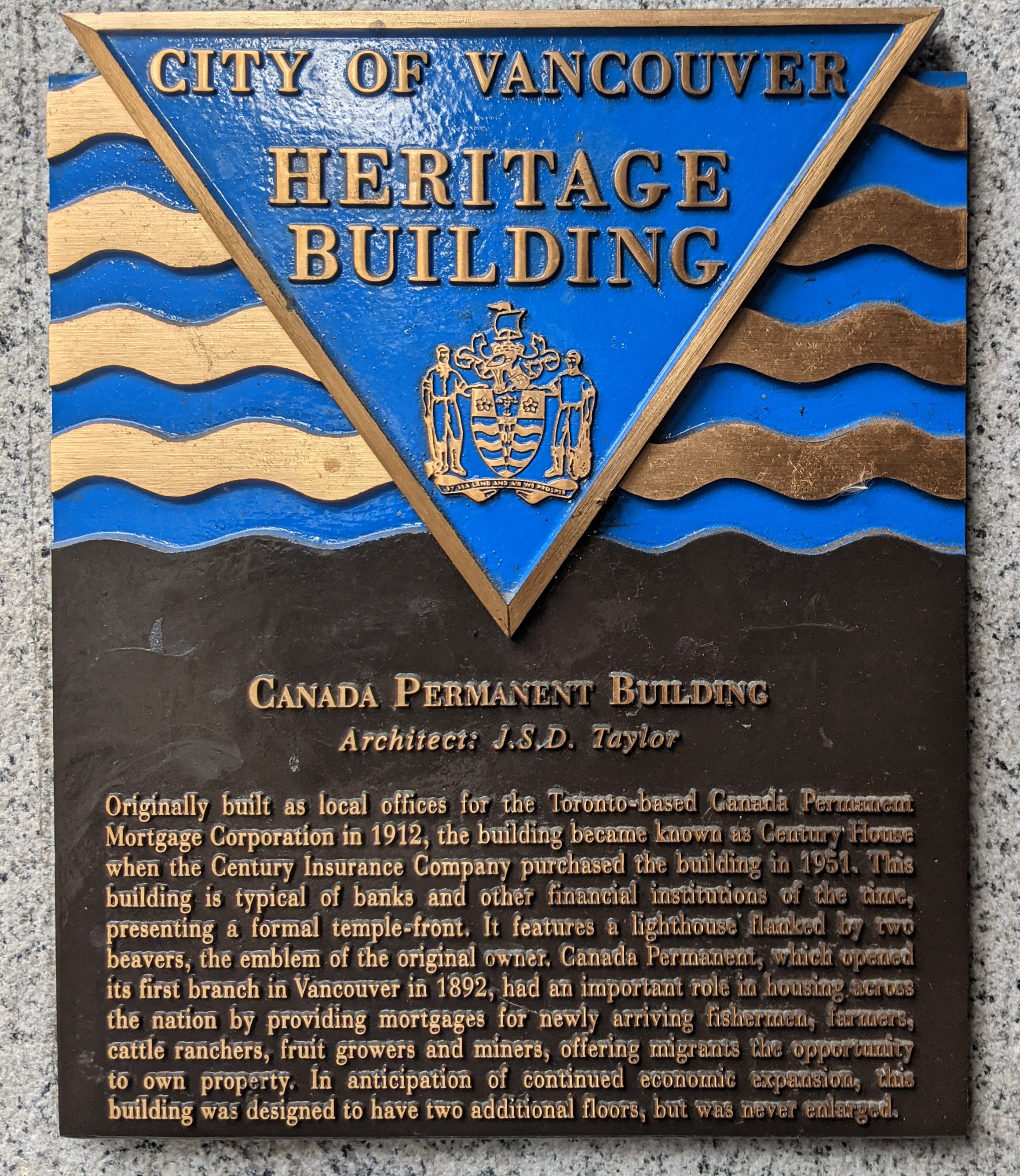
Canada Permanent Building Architect: J.S.D. Taylor Originally built as local offices for the Toronto-based Canada Permanent Mortgage Corporation in 1912, the building became known as Century House when the Century Insurance Company purchased the building in 1951. This building is typical of banks and other financial institutions of the time, presenting as a formal temple-front. It features a lighthouse flanked by two beavers, the emblem of the original owner. Canada Permanent, which opened its first branch in Vancouver in 1892, had an important role in housing across the nation by providing mortgages for newly arriving fishermen, farmers, cattle ranchers, fruit growers and miners, offering migrants the opportunity to own property. In anticipation of continued economic expansion, this building was designed to have two additional floors, but was never enlarged.
Licensing
[edit]- You are free:
- to share – to copy, distribute and transmit the work
- to remix – to adapt the work
- Under the following conditions:
- attribution – You must give appropriate credit, provide a link to the license, and indicate if changes were made. You may do so in any reasonable manner, but not in any way that suggests the licensor endorses you or your use.
- share alike – If you remix, transform, or build upon the material, you must distribute your contributions under the same or compatible license as the original.
File history
Click on a date/time to view the file as it appeared at that time.
Date/Time | Thumbnail | Dimensions | User | Comment | |
---|---|---|---|---|---|
current | 04:00, 15 December 2020 | 2,319 × 2,673 (1.49 MB) | Luke.Ernz (talk | contribs) | Uploaded own work with UploadWizard |
You cannot overwrite this file.
File usage on Commons
There are no pages that use this file.
File usage on other wikis
The following other wikis use this file:
- Usage on fr.wikipedia.org
Metadata
This file contains additional information such as Exif metadata which may have been added by the digital camera, scanner, or software program used to create or digitize it. If the file has been modified from its original state, some details such as the timestamp may not fully reflect those of the original file. The timestamp is only as accurate as the clock in the camera, and it may be completely wrong.
Camera manufacturer | |
---|---|
Camera model | Pixel 2 |
Exposure time | 2,351/1,000,000 sec (0.002351) |
F-number | f/1.8 |
ISO speed rating | 53 |
Date and time of data generation | 14:05, 14 December 2020 |
Lens focal length | 4.442 mm |
Latitude | 49° 17′ 1.69″ N |
Longitude | 123° 6′ 45.48″ W |
Altitude | 18.31 meters above sea level |
Width | 3,024 px |
Height | 4,032 px |
Orientation | Normal |
Horizontal resolution | 72 dpi |
Vertical resolution | 72 dpi |
Software used | HDR+ 1.0.345618096zd |
File change date and time | 14:05, 14 December 2020 |
Subsampling ratio of Y to C |
|
Y and C positioning | Centered |
Exposure Program | Normal program |
Exif version | 2.31 |
Date and time of digitizing | 14:05, 14 December 2020 |
Meaning of each component |
|
APEX shutter speed | 8.73 |
APEX aperture | 1.7 |
APEX brightness | 6.34 |
APEX exposure bias | 0 |
Maximum land aperture | 1.7 APEX (f/1.8) |
Subject distance | 0.377 meters |
Metering mode | Center weighted average |
Flash | Flash did not fire, compulsory flash suppression |
DateTime subseconds | 005736 |
DateTimeOriginal subseconds | 005736 |
DateTimeDigitized subseconds | 005736 |
Supported Flashpix version | 1 |
Color space | sRGB |
Sensing method | One-chip color area sensor |
Scene type | A directly photographed image |
Custom image processing | Custom process |
Exposure mode | Auto exposure |
White balance | Auto white balance |
Digital zoom ratio | 0 |
Focal length in 35 mm film | 27 mm |
Scene capture type | Standard |
Contrast | Normal |
Saturation | Normal |
Sharpness | Normal |
Subject distance range | Macro |
Unique image ID | ed834c56ffdafff50000000000000000 |
GPS time (atomic clock) | 22:05 |
Measurement precision | Poor (31.981) |
Reference for direction of image | Magnetic direction |
Direction of image | 50 |
GPS date | 14 December 2020 |
GPS tag version | 0.0.2.2 |
Structured data
Items portrayed in this file
depicts
some value
49°17'1.691"N, 123°6'45.479"W
14 December 2020
0.002351 second
1.8
4.442 millimetre
image/jpeg
eacd0007800529bc7a06742db24e5c9e749827cf
1,565,825 byte
2,673 pixel
2,319 pixel
- Heritage properties in Canada with known IDs
- Heritage properties in Canada missing SDC depicts
- Heritage properties in Canada missing SDC location of creation
- Files with coordinates missing SDC location of creation
- CC-BY-SA-4.0
- Self-published work
- Uploaded via Campaign:wlm-ca
- Canada photographs taken on 2020-12-14