File:Canada provinces evolution 2.gif
ナビゲーションに移動
検索に移動

このプレビューのサイズ: 694 × 600 ピクセル。 その他の解像度: 278 × 240 ピクセル | 556 × 480 ピクセル | 1,000 × 864 ピクセル。
元のファイル (1,000 × 864 ピクセル、ファイルサイズ: 243キロバイト、MIME タイプ: image/gif、ループします、20 フレーム、1分 13秒)
キャプション
キャプション
このファイルの内容を1行で記述してください
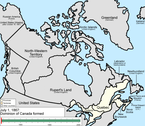
Animated map showing changes to the borders of Canadian provinces and territories over time

|
This image could be re-created using vector graphics as an SVG file. This has several advantages; see Commons:Media for cleanup for more information. If an SVG form of this image is available, please upload it and afterwards replace this template with
{{vector version available|new image name}}.
It is recommended to name the SVG file "Canada provinces evolution 2.svg" - then the template Vector version available (or Vva) does not need the new image name parameter. |
|
概要
[編集]
| 解説 |
English: Animation of the changes to the borders of Canada.
The captions read as follows:
|
| 日付 | |
| 原典 | 投稿者自身による著作物 |
| 作者 | Golbez |
ライセンス
[編集]
この作品の著作権者である私は、この作品を以下のライセンスで提供します。
このファイルはクリエイティブ・コモンズ 表示-継承 3.0 非移植ライセンスのもとに利用を許諾されています。
- あなたは以下の条件に従う場合に限り、自由に
- 共有 – 本作品を複製、頒布、展示、実演できます。
- 再構成 – 二次的著作物を作成できます。
- あなたの従うべき条件は以下の通りです。
- 表示 – あなたは適切なクレジットを表示し、ライセンスへのリンクを提供し、変更があったらその旨を示さなければなりません。これらは合理的であればどのような方法で行っても構いませんが、許諾者があなたやあなたの利用行為を支持していると示唆するような方法は除きます。
- 継承 – もしあなたがこの作品をリミックスしたり、改変したり、加工した場合には、あなたはあなたの貢献部分を元の作品とこれと同一または互換性があるライセンスの下に頒布しなければなりません。

|
この文書は、フリーソフトウェア財団発行のGNUフリー文書利用許諾書 (GNU Free Documentation License) 1.2またはそれ以降のバージョンの規約に基づき、複製や再配布、改変が許可されます。不可変更部分、表紙、背表紙はありません。このライセンスの複製は、GNUフリー文書利用許諾書という章に含まれています。 |
あなたは上記のライセンスから、どれか一つ以上を選択できます。
ファイルの履歴
過去の版のファイルを表示するには、その版の日時をクリックしてください。
| 日付と時刻 | サムネイル | 寸法 | 利用者 | コメント | |
|---|---|---|---|---|---|
| 現在の版 | 2009年7月14日 (火) 22:37 | | 1,000 × 864 (243キロバイト) | Golbez (トーク | 投稿記録) | {{Information |Description=Animation of the changes to the borders of Canada. |Source=self-made |Date=July 15, 2009 |Author= Golbez |Permission= |other_versions= }} Category:Maps of the history of Canada Category:Animated GIF [[Ca |
このファイルは上書きできません。
ファイルの使用状況
このファイルを使用しているページはありません。
グローバルなファイル使用状況
以下に挙げる他のウィキがこの画像を使っています:
- ar.wikipedia.org での使用状況
- be-tarask.wikipedia.org での使用状況
- bg.wikipedia.org での使用状況
- ca.wikipedia.org での使用状況
- ckb.wikipedia.org での使用状況
- cs.wikipedia.org での使用状況
- en.wikipedia.org での使用状況
- John A. Macdonald
- Manitoba
- Northwest Territories
- Ontario
- History of Canada
- Provinces and territories of Canada
- Talk:Labrador
- List of proposed provinces and territories of Canada
- Quebec Boundaries Extension Act, 1912
- History of Alberta
- Quebec Boundary Extension Act, 1898
- History of Western civilization
- Wikipedia:Featured pictures thumbs/06
- Canada
- Talk:Territorial evolution of Canada
- List of Canada-related topics by provinces and territories
- Demographics of the Northwest Territories
- Speaker of the Legislative Assembly of the Northwest Territories
- Portal:Canada/Selected picture
- Wikipedia:Featured pictures/Diagrams, drawings, and maps/Maps
- Wikipedia:Featured picture candidates/delist/2009
- Wikipedia:Featured picture candidates/delist/Canada provinces evolution.gif
- Talk:History of Canada/Archive 1
- Wikipedia:Featured picture candidates/November-2009
- Wikipedia:Featured picture candidates/Non-Native American Nations Control over N America 1750-2008.gif
- User:North8000
- User:Ezekiel11324/bordercity
- Former colonies and territories in Canada
- User:Soulscanner/Sandbox/CanHist
- Wikipedia:Reference desk/Archives/Miscellaneous/2011 August 15
- User talk:Golbez/Archive 6
- Template:POTD/2015-07-01
- Wikipedia:Picture of the day/July 2015
- Wikipedia:Main Page history/2015 July 1
- Timeline of Alberta history
- User:Falcaorib/Canada, United States and Mexico
- en.wikibooks.org での使用状況
- es.wikipedia.org での使用状況
このファイルのグローバル使用状況を表示する。